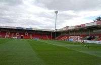
Whaddon Road
 | |
| Full name | Whaddon Road |
|---|---|
| Capacity | 7,066 |
| Field size | 111 x 72 yards |
| Construction | |
| Built | 1927 |
| Opened | 1927 |
| Tenants | |
|
Cheltenham Town (1932-present) Gloucester City (2010-present) | |
- You may be looking for Cambridge United's stadium, the Abbey Stadium.
Whaddon Road is a football stadium in Cheltenham, England. It is the home ground of Cheltenham Town F.C. and shared with Gloucester City A.F.C.. It has a total capacity of 7,066, with a mixture of seating and terracing. The ground's official name was the Victory Sports Ground[1] until April 2009 when it was renamed the Abbey Business Stadium through a sponsorship deal.[2] It was announced on 13 July 2015 that the club had agreed a three year deal to rename the stadium The World of Smile Stadium.[3]
History
The stadium on the site of what was The Berkeley Hunt kennels was built by the Cheltenham Original Brewery in 1927 and has been the home of Cheltenham Town since 1932 but did not host senior football for 67 years. Cheltenham marked their 70th anniversary at the stadium by winning promotion to the Football League Second Division, the third tier of English football, for the first time.
The record attendance is 8,326 for a game versus Reading, FA Cup 1st Round, 17 November 1956. Whaddon Road was the smallest League One stadium to be used in the 2007-08 and 2008-09 season.
Stands

The ground is made up of 4 stands:
- Hazlewoods Stand (Whaddon Road) - capacity 1,100. An all-seated stand behind one of the goals, the Carlsberg Stand was opened in 2005 and is designated to away fans. For the 2009-10 season it was given to home supporters, but after one season it was returned to away fans.
- QualitySolicitors Thomson & Bancks Stand (Wymans Road) - capacity 2,034. An all-seated stand that runs down one side of the pitch. The stand was opened in November 2001 and is home to the vocal "Wymans" supporters. For big games, two sections of the stand are given to away supporters.
- Liberty Mutual Insurance Stand (Prestbury Road End) - capacity about 2,100. Opened in 1999, this is a covered terrace behind the other goal, the LMI Terrace is the home standing end.
- Jelf Stand (Main Stand) - capacity about 1,800. Built in 1963, it is a mixture of terracing (Tunnel and Paddock enclosures) at the front and seating at the back. The Main Stand runs down on side of the pitch, but is unusual in that it does not stretch the full length of the touchline and does not reach either corner flag. It contains the players dressing rooms, hospitality, directors and press boxes. It also includes a family section.
Other Teams
Other teams to have used Whaddon Road as a home venue are
- Gloucester City
- St Marks
- Endsleigh
- Cheltenham Original Brewery
The ground is also used as the venue for many local league and youth cup finals.
International Games
The stadium has been used for the following international games
- 28 January 1939 England Amateur Vs Wales Amateur (5-2)
- 2 March 1993 England semi-pro Vs Wales Semi-Pro (2-1)
- 4 September 2005 England Under-17 Vs Italy Under-17 (1-2)
- 27 October 2011 England Under-16 Vs Wales Under-16 (4-0)
Sources
References
- ↑ "Ground share and stadium sponsor a possibility". Cheltenham Town F.C. 14 February 2009. Retrieved 14 February 2009.
- ↑ "New Stadium Sponsor announced". Cheltenham Town F.C. 24 April 2009. Retrieved 24 April 2009.
- ↑ http://www.westerndailypress.co.uk/Welcome-World-Smile-Stadium-Cheltenham-Town/story-26891051-detail/story.html
External links
- Club website
- Pictures at StadiumDB.com
| ||||||
Coordinates: 51°54′22.17″N 2°3′36.76″W / 51.9061583°N 2.0602111°W