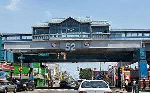
52nd Street (SEPTA station)
52nd Street | |||||||||||
|---|---|---|---|---|---|---|---|---|---|---|---|
| SEPTA rapid transit station | |||||||||||
 Exterior of station from street level. | |||||||||||
| Location |
Fifty-second & Market Streets Philadelphia, Pennsylvania | ||||||||||
| Coordinates | 39°57′35″N 75°13′30″W / 39.9597°N 75.2250°WCoordinates: 39°57′35″N 75°13′30″W / 39.9597°N 75.2250°W | ||||||||||
| Owned by | Southeastern Pennsylvania Transportation Authority | ||||||||||
| Line(s) | |||||||||||
| Platforms | 2 side platforms (Market-Frankford) | ||||||||||
| Tracks | 2 | ||||||||||
| Connections | Bus routes 31 and 52 | ||||||||||
| Construction | |||||||||||
| Disabled access | Yes | ||||||||||
| History | |||||||||||
| Opened | March 4, 1907 | ||||||||||
| Rebuilt | April 14, 2008 | ||||||||||
| Electrified | 700 volts DC | ||||||||||
| Services | |||||||||||
| |||||||||||
52nd Street Station is an elevated stop on the Market-Frankford Line, above the intersection of 52nd Street and Market Street in Philadelphia, Pennsylvania. The station lies at the junction of four neighborhoods. Haddington is to the northwest, Dunlap to the northeast, Walnut Hill to the southeast, and Cobbs Creek to the southwest.
The SEPTA bus routes serving 52nd Street are routes 31 and 52. 52nd Street is a major shopping corridor.
52nd Street Station is one of the original Market-Frankford Elevated stations built by the Philadelphia Rapid Transit Company in 1907. It was reconstructed in 2007 as part of SEPTA's reconstruction of the Market Street Elevated line.[1]
The News Media and Philadelphia Police Department have labeled this intersection the "Worst Corner In The City" due to the high crime and rate of shootings on the block. There were 16 shootings within a 4-month span beginning February 2007.[2]
Station layout
| P Platform level |
Side platform, doors will open on the right | |
| Westbound | ← Market–Frankford Line toward 69th Street (56th Street) | |
| Eastbound | → Market–Frankford Line toward Frankford (46th Street) → | |
| Side platform, doors will open on the right | ||
| M | Mezzanine | to entrances/exits, fare control |
| G | Street Level | Entrances/Exits |
Image gallery
-

52nd Street Station with 1970's Bicentennial trim before the 2007-2008 reconstruction project.
-

An MFL Blue Line train leaves 52nd Street Station bound for 69th Street station
References
- ↑ Market Street Elevated Reconstruction Project
- ↑ Gambacorta, David (2007-04-11). "52nd & Market Called City's Deadliest Corner". Philadelphia Inquirer. Retrieved 2008-09-04.