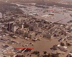
1979 Easter flood
 Flood waters inundated downtown Jackson during the "1979 Easter Flood". | |
| Date | April 1979 |
|---|---|
| Location |
Hinds County, Madison County, Rankin County Map showing the Pearl River in Mississippi. |
| Deaths | 4 [1] |
| Property damage |
$500 then[1] $1.63 billion today[2] |
The 1979 Easter flood was among the most costly and devastating ever to occur in Mississippi, with $500-700 million in damages.[3]Coordinates: 32°17′N 90°11′W / 32.29°N 90.18°W This is equivalent to $1.63 billion in present day terms[2]. It was the result of the Pearl River being overwhelmed by severe rain upstream. Floodwaters sent the Pearl 15 feet above flood stage. More than 17,000 people in the cities of Jackson, Flowood, Pearl, Richland and other communities were forced from their homes. The flooding of the Pearl River placed most of Jackson, the state's capital city, under water.
The river
The Pearl River is 490 miles long. It begins in Winston County, Mississippi and ends at the Mississippi Sound. Northeast of Jackson, the man-made Ross Barnett Reservoir is formed by a dam in the Pearl River.
Present
Flood stage at Jackson in 1979 was considered to be 18 feet (relative to the gauge datum on Pearl River), but as of 2004, this stage was set as 28 feet.[1]
External links
- NBC News Update Easter 1979 broadcast which includes coverage of the 1979 Easter flood.
- National Weather Service Forecast Office: Jackson, MS
References
- 1 2 3 Meteorologist-In-Charge in 1979. "Excerpts from a preliminary report by the Meteorologist-In-Charge in 1979 to the Acting Director Southern Region of the National Weather Service dated April 20, 1979". National Weather Service Jackson.
- 1 2 Consumer Price Index (estimate) 1800–. Federal Reserve Bank of Minneapolis. Retrieved November 10, 2015.
- ↑ http://www.srh.noaa.gov/jan/?n=1979_04_17_easter_flood