1901 Atlantic hurricane season
| |
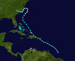
| Season summary map |
| First system formed |
June 11, 1901 (June 11, 1901) |
| Last system dissipated |
November 6, 1901 (November 6, 1901) |
| Strongest storm1 |
Seven – 961 mbar (hPa) (28.38 inHg), 105 mph (165 km/h) |
| Total depressions |
13 |
| Total storms |
13 |
| Hurricanes |
6 |
| Major hurricanes (Cat. 3+) |
0 |
| Total fatalities |
1 |
| Total damage |
$1 million (1901 USD) |
| 1Strongest storm is determined by lowest pressure |
Atlantic hurricane seasons
1899, 1900, 1901, 1902, 1903 |
The 1901 Atlantic hurricane season was a generally average period of tropical cyclogenesis in 1901,[nb 1] featuring the development of thirteen tropical cyclones of at least tropical storm strength, of which six strengthened further to become hurricanes. The Atlantic hurricane reanalysis project also indicated but could not confirm the presence of an additional tropical in October 1901.[2] However, the reanalysis added a previously undetected hurricane to the Atlantic hurricane database (HURDAT). Although there were no official bounds to the hurricane season, activity was spread evenly during the summer and autumn months of 1901, beginning with the development of the first disturbance south of Cuba on June 11 and ending with the dissipation of the final disturbance well northeast of Bermuda on November 6. The seventh tropical cyclone that year was the strongest, attaining maximum sustained winds of 105 mph (165 km/h), equivalent to a modern day Category 2 hurricane.
Storms
Tropical Storm One
| Tropical storm (SSHWS) |
|
|
| Duration |
June 11 – June 15 |
| Peak intensity |
40 mph (65 km/h) (1-min) <1010 mbar (hPa) |
The season had an early start with a tropical storm forming near the Isla de la Juventud on June 11. It passed over the western tip of Cuba and moved through the Gulf of Mexico as a weak tropical storm, finally hitting the Florida Panhandle on June 14. After moving inland, the storm rapidly weakened to a tropical depression. It continued northward and eventually curved northwestward. By June 15, the storm dissipated over southern Illinois.
Tropical Storm Two
| Tropical storm (SSHWS) |
|
|
| Duration |
July 1 – July 10 |
| Peak intensity |
70 mph (110 km/h) (1-min) < 1007 mbar (hPa) |
The next storm formed on July 1 east of Venezuela. It moved briskly through the Caribbean Sea, hitting Jamaica and the western tip of Cuba on the way, and finally made landfall in Southeast Texas as a minimal tropical storm.
Hurricane Three
| Category 1 hurricane (SSHWS) |
|
|
| Duration |
July 4 – July 13 |
| Peak intensity |
80 mph (130 km/h) (1-min) 983 mbar (hPa) |
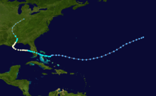
Another July storm formed near the same location as the previous storm on July 4. It moved westward, hitting the Lesser Antilles, Puerto Rico, and the Dominican Republic as a tropical storm. The storm strengthened to hurricane strength, hit the Outer Banks, and looped around to hit near the North Carolina/South Carolina border.
Hurricane Four
| Category 1 hurricane (SSHWS) |
|
|
| Duration |
August 2 – August 16 |
| Peak intensity |
90 mph (150 km/h) (1-min) 973 mbar (hPa) |
The season's fourth storm had an unusual origin southwest of the Azores Islands on August 2. It moved west-southwestward for six days before reaching tropical storm strength near the Bahamas. It hit near West Palm Beach on August 10, crossed South Florida. It hit Grand Isle, Louisiana on August 14, producing levee breeches which flooded New Orleans, and destroyed every building in Port Eads, Louisiana other than the lighthouse. It hit near Gulfport, Mississippi on August 16, after causing 10 deaths and over $1 million in damage (1901 USD).
Tropical Storm Five
| Tropical storm (SSHWS) |
|
|
| Duration |
August 18 – August 22 |
| Peak intensity |
50 mph (85 km/h) (1-min) <1012 mbar (hPa) |
The fifth storm formed and moved through Grenada in middle August.
Hurricane Six
| Category 1 hurricane (SSHWS) |
|
|
| Duration |
August 25 – August 30 |
| Peak intensity |
80 mph (130 km/h) (1-min) <991 mbar (hPa) |
A category 1 hurricane existed throughout the day of August 27 in the mid-Atlantic.It developed from a tropical storm that formed east of the Cape Verde Islands on August 25.
Hurricane Seven
| Category 2 hurricane (SSHWS) |
|
|
| Duration |
August 29 – September 10 |
| Peak intensity |
105 mph (165 km/h) (1-min) |
A tropical storm developed south of the Cape Verde Islands on August 29.By September 1 it had developed into a Category 1 Cape Verde-type hurricane.It continued to grow reaching Category 2 strength by September 3.It produced 105 mph (165 km/h) winds before eventually becoming extratropical and dissipating on September 11 in the north Atlantic.
Hurricane Eight
| Category 1 hurricane (SSHWS) |
|
|
| Duration |
September 9 – September 18 |
| Peak intensity |
80 mph (130 km/h) (1-min) <1001 mbar (hPa) |
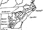
Tropical Storm Eight moved through the northern Lesser Antilles and the Greater Antilles, recurved, and hit near Pensacola, Florida in early to middle September. The system caused a significant amount of rain across Georgia and the Carolinas, with the maximum amount reported 11.4 inches (290 mm) at Americus, Georgia.[3]
Tropical Storm Nine
| Tropical storm (SSHWS) |
|
|
| Duration |
September 12 – September 17 |
| Peak intensity |
60 mph (95 km/h) (1-min) |
The season's ninth storm formed and died off the coast of Africa.
Tropical Storm Ten
| Tropical storm (SSHWS) |
|
|
| Duration |
September 21 – September 28 |
| Peak intensity |
50 mph (85 km/h) (1-min) |
The tenth storm of the season formed in the central Caribbean, moved northward through Cuba, and hit the Florida Panhandle in late September. In Florida, a church was destroyed killing 1 person.
Tropical Storm Eleven
| Tropical storm (SSHWS) |
|
|
| Duration |
October 5 – October 10 |
| Peak intensity |
70 mph (110 km/h) (1-min) |
The eleventh storm remained out at sea.
Tropical Storm Twelve
| Tropical storm (SSHWS) |
|
|
| Duration |
October 15 – October 18 |
| Peak intensity |
60 mph (95 km/h) (1-min) |
Tropical Storm Twelve formed south of Cuba, crossed over, and strengthened before becoming extratropical.
Hurricane Thirteen
| Category 1 hurricane (SSHWS) |
|
|
| Duration |
October 30 – November 5 |
| Peak intensity |
80 mph (130 km/h) (1-min) <989 mbar (hPa) |
The final storm formed north of Puerto Rico in late October, reached hurricane strength southeast of Bermuda, and dissipated in early November.
See also
Notes
References
External links


.png)


