Ōmachi, Saga
| Ōmachi 大町町 | |
|---|---|
| Town | |
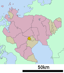
 Location of Ōmachi in Saga Prefecture | |
 Ōmachi Location in Japan | |
| Coordinates: 33°13′N 130°7′E / 33.217°N 130.117°ECoordinates: 33°13′N 130°7′E / 33.217°N 130.117°E | |
| Country | Japan |
| Region | Kyushu |
| Prefecture | Saga Prefecture |
| District | Kishima |
| Government | |
| • Mayor | Hiroshisei Takemura |
| Area | |
| • Total | 11.46 km2 (4.42 sq mi) |
| Population (February 1, 2009) | |
| • Total | 7,542 |
| • Density | 660/km2 (1,700/sq mi) |
| Symbols | |
| • Tree | Sweet Osmanthus |
| • Flower | Pansy |
| Time zone | Japan Standard Time (UTC+9) |
| City Hall Address |
5017 Ōmachi, Ōmachi-chō, Kishima-gun, Saga-ken 849-2101 |
| Website |
www |
Ōmachi (大町町 Ōmachi-chō) is a town located in Kishima District, Saga Prefecture, Japan.
Geography
- Mountains: The northern part of town gradually becomes mountainous.
- Rivers: Rokkaku River
- Lakes: The northern, mountainous part of town is dotted with ponds.
Adjoining Cities and Municipalities
History
- April 1, 1889 - The village of Fukumo merges with the village of Ōmachi.
- January 1, 1936 - The village of Ōmachi gains town status.
Economy
- Agricultural Products: Rice, barley, cucumbers, strawberries, and chickens.
- There was a coal mine which operated until 1960.
Education
- Saga Prefectural Business High School
- Ōmachi Junior High School
- Ōmachi Elementary School
Transportation
Air
- The nearest airport is Saga Airport
Rail
Road
- Expressways: None
- National Highways: Route 34
- Prefectural Roads: Saga Prefecture Route 36
Sister cities
External links
 Media related to Ōmachi, Saga at Wikimedia Commons
- Ōmachi official website (Japanese)
| ||||||||||||||||||||||||||||||||||
|
This article is issued from Wikipedia - version of the Saturday, November 07, 2015. The text is available under the Creative Commons Attribution/Share Alike but additional terms may apply for the media files.