Đavolja Varoš
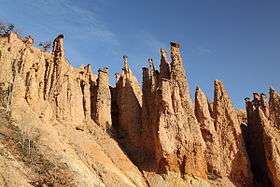
Đavolja Varoš (Serbian Cyrillic: Ђавоља варош, meaning "Devil's Town") is a peculiar rock formation, located in south Serbia on the Radan Mountain near Kuršumlija. It features 202 exotic formations described as earth pyramids or "towers", as the locals refer to them. They are 2-15 m tall and 4-6 m wide at the base. These formations were created by strong erosion of the soil that was scene of intense volcanic activity millions of years ago. [1] Most of the towers have "caps" or "heads" of andesite, which protect them from further erosion.[2]
Since 1959, Đavolja Varoš has been protected by the state and a 1995 decision of the Serbian Government declared it a major natural monument subject to category one protection.[3]
A natural spring is located beneath the formations and has a high mineral concentration. There are two springs: Đavolja voda (Devil’s Water), with extremely acidic water (pH 1.5) and high mineral concentration (15 g/l of water), and Crveno vrelo (Red Well).[3]
Đavolja Varoš was a nominee in the New Seven Wonders of Nature campaign.[4]
See also
References
External links
|
|---|
| | 2002 applicants | |
|---|
| | 2009 applicants | |
|---|
| | 2010 applicants | |
|---|
| *Joint Cultural Heritage by the four countries |
|
|
|---|
| | National parks | |
|---|
| | Nature reserves | |
|---|
| | Nature parks | |
|---|
| Landscapes of
outstanding features | |
|---|
| Natural monuments
(selection) | |
|---|
|
|
|---|
| Seven Serbian Wonders of Construction
| | | Seven Serbian Wonders of Nature
|
|
