Zverino Island


Zverino Island (Bulgarian: остров Зверино, ‘Ostrov Zverino’ \'os-trov zve-ri-'no\) is the largest and westernmost island in the Meade group lying in the north entrance to McFarlane Strait in the South Shetland Islands, Antarctica. It is extending 1.2 km by 700 m, with surface area of 48 hectares (120 acres),[1] and is snow-free in summer.
The island is named after the settlement of Zverino in Western Bulgaria.
Location
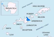
Zverino Island is located at 62°27′09″S 60°04′25″W / 62.45250°S 60.07361°WCoordinates: 62°27′09″S 60°04′25″W / 62.45250°S 60.07361°W, which is 2.4 km east of Williams Point and 2.1 km northeast of Ficheto Point on Livingston Island, 1.9 km west of Duff Point on Greenwich Island, and is separated from neighbouring Cave Island to the east-northeast by the 110 m wide Glogovo Passage. British mapping in 1935 and 1968, Chilean in 1971, Argentine in 1980, Spanish in 1991, and Bulgarian in 2005 and 2009.
Maps
- L.L. Ivanov et al. Antarctica: Livingston Island and Greenwich Island, South Shetland Islands. Scale 1:100000 topographic map. Sofia: Antarctic Place-names Commission of Bulgaria, 2005.
Notes
- ↑ L.L. Ivanov. Antarctica: Livingston Island and Greenwich, Robert, Snow and Smith Islands. Scale 1:120000 topographic map. Troyan: Manfred Wörner Foundation, 2009. ISBN 978-954-92032-6-4 (Updated second edition 2010. ISBN 978-954-92032-9-5)
References
This article includes information from the Antarctic Place-names Commission of Bulgaria which is used with permission.