Zistersdorf
| Zistersdorf | ||
|---|---|---|
| ||
 Zistersdorf Location within Austria | ||
| Coordinates: 48°31′N 16°45′E / 48.517°N 16.750°ECoordinates: 48°31′N 16°45′E / 48.517°N 16.750°E | ||
| Country | Austria | |
| State | Lower Austria | |
| District | Gänserndorf | |
| Government | ||
| • Mayor | Wolfgang Peischl | |
| Area | ||
| • Total | 88,361 km2 (34,116 sq mi) | |
| Elevation | 199 m (653 ft) | |
| Population (1 January 2014)[1] | ||
| • Total | 5,351 | |
| • Density | 0.061/km2 (0.16/sq mi) | |
| Time zone | CET (UTC+1) | |
| • Summer (DST) | CEST (UTC+2) | |
| Postal code | 2225 | |
| Area code | 02532 | |
| Website | www.zistersdorf.at | |

Zistersdorf is a town in the district of Gänserndorf in the Austrian state of Lower Austria.
Population
| Historical population | ||
|---|---|---|
| Year | Pop. | ±% |
| 1869 | 5,917 | — |
| 1880 | 6,410 | +8.3% |
| 1890 | 6,721 | +4.9% |
| 1900 | 6,787 | +1.0% |
| 1910 | 7,183 | +5.8% |
| 1923 | 6,656 | −7.3% |
| 1934 | 6,667 | +0.2% |
| 1939 | 7,041 | +5.6% |
| 1951 | 7,448 | +5.8% |
| 1961 | 6,776 | −9.0% |
| 1971 | 6,421 | −5.2% |
| 1981 | 5,792 | −9.8% |
| 1991 | 5,524 | −4.6% |
| 2001 | 5,624 | +1.8% |
| 2011 | 5,465 | −2.8% |
References
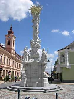
Plague column in Zistersdorf.
External links
| Wikimedia Commons has media related to Category:Zistersdorf. |