Zichy Land
| Russian: Земля Зичи | |
|---|---|
|
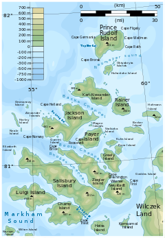
Location of the Zichy Land subgroup of the Franz Josef Archipelago. | |
| Geography | |
| Location | Arctic |
| Coordinates | 81°00′N 56°00′E / 81.000°N 56.000°E |
| Archipelago | Franz Josef Archipelago |
| Country | |
| Demographics | |
| Population | 0 |

Zichy Land (Земля Зичи; Zemlya Zichy) is a geographical subgroup of Franz Josef Land, Russia. It is formed by the central cluster of large islands in the midst of the archipelago. The islands are separated from each other by narrow sounds that are frozen most of the year, forming a compact whole.[1]
This island group was named after Hungarian Count Ödön Zichy (1811-1894) who was, beside Count Johann Nepomuk Wilczek, the second highest sponsor for the Austro-Hungarian North Pole Expedition to Franz Josef Land.
Geography
The broad channel to the west of Zichy Land is known as Markham Channel (Russian: Пролив маркама; Proliv Markama), after British polar explorer Admiral Sir Albert Hastings Markham.
The northernmost point of Zichy Land is Mys Bema in Karl-Alexander Island and its southernmost point is Mys Fiume in Champ Island. The distance between both is 114 km (71 mi). Mys Armitidzh in Luigi Island is the westernmost point of the subgroup. The highest point is a 620 m elevation located on Wiener Neustadt Island.[2] The channels separating the islands in the southeastern area of the group are very narrow.
Islands
The individual islands forming the Zemlya Zichy archipelago are (from North to south):
- Karl-Alexander Island
- Rainer Island
- Jackson Island
- Payer Island
- Greely Island and adjacent islands.
- Ziegler Island
- Salisbury Island
- Wiener Neustadt Island
- Luigi Island
- Champ Island