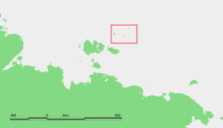
Zhokhov Island
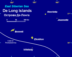
Zhokhov Island (Russian: Остров Жохова; Ostrov Zhokhova) is an island in the East Siberian Sea, situated 128 km north east of Novaya Sibir Island, the easternmost of the New Siberian Islands. Zhokhov Island belongs to the De Long group. It has an area of 77 km2 (30 sq mi). The highest point of the island is 123 m (404 ft). This island belongs to the Sakha (Yakutia) Republic administrative division of Russia.[1]
The sea surrounding this island is covered with fast ice in the winter and the climate is severe. The surrounding sea is obstructed by pack ice, even during the summer.
Geology
Zhokhov Island consists of extrusive basalt lava flows and tuffs. The bulk of this island is made up of a thick stack of olivine basalt, olivine trachybasalt, and nepheline basalt lava flows. Overlying these lava flows is a layer of friable volcanic ash and tuff that is capped by a thick basalt lava flow. The total thickness of volcanic rocks exposed within Zhokhov Island is about 400 meters[2][3]
Vegetation
Rush/grass, forb, cryptogam tundra covers the Zhokhov Island. It is tundra consisting mostly of very low-growing grasses, rushes, forbs, mosses, lichens, and liverworts. These plants either mostly or completely cover the surface of the ground. The soils are typically moist, fine-grained, and often hummocky.[4]
History
Mesolithic humans occupied the island as early as 6000 BCE. Tools of stone, bone, antler, and ivory have been found, as well as wooden arrow shafts and a sledge runner. Animal remains suggest a culture dependent on the hunting of polar bears and reindeer.[5]
In modern times, Zhokhov Island was discovered by the 1910–1915 Russian Arctic Ocean Hydrographic Expedition under Boris Vilkitsky on the ships Vaygach and Taymyr. It was originally named Novopashenniy Island but was later renamed after Alexi Zhokhov, a member of the expedition.[6]
Climate
| Climate data for Zhokov Island | |||||||||||||
|---|---|---|---|---|---|---|---|---|---|---|---|---|---|
| Month | Jan | Feb | Mar | Apr | May | Jun | Jul | Aug | Sep | Oct | Nov | Dec | Year |
| Record high °C (°F) | −7.8 (18) |
−2.8 (27) |
−7.8 (18) |
−3.0 (26.6) |
7.2 (45) |
11.0 (51.8) |
14.5 (58.1) |
18.0 (64.4) |
7.5 (45.5) |
11.0 (51.8) |
−1.7 (28.9) |
−3.2 (26.2) |
18.0 (64.4) |
| Average high °C (°F) | −25.5 (−13.9) |
−26.5 (−15.7) |
−24.2 (−11.6) |
−17.4 (0.7) |
−6.9 (19.6) |
−0.1 (31.8) |
2.7 (36.9) |
1.4 (34.5) |
−2.6 (27.3) |
−11.1 (12) |
−20.1 (−4.2) |
−24.2 (−11.6) |
−14.1 (6.6) |
| Daily mean °C (°F) | −28.3 (−18.9) |
−29.3 (−20.7) |
−27.2 (−17) |
−20.4 (−4.7) |
−9.0 (15.8) |
−1.5 (29.3) |
1.1 (34) |
0.3 (32.5) |
−4.3 (24.3) |
−13.8 (7.2) |
−22.9 (−9.2) |
−26.9 (−16.4) |
−16.6 (2.1) |
| Average low °C (°F) | −31.6 (−24.9) |
−32.4 (−26.3) |
−30.7 (−23.3) |
−24.4 (−11.9) |
−12.0 (10.4) |
−3.3 (26.1) |
−0.6 (30.9) |
−1.9 (28.6) |
−6.6 (20.1) |
−17.1 (1.2) |
−26.1 (−15) |
−29.9 (−21.8) |
−19.5 (−3.1) |
| Record low °C (°F) | −46.1 (−51) |
−48.0 (−54.4) |
−45.0 (−49) |
−38.0 (−36.4) |
−26.0 (−14.8) |
−15.0 (5) |
−7.6 (18.3) |
−8.9 (16) |
−23.1 (−9.6) |
−33.0 (−27.4) |
−38.0 (−36.4) |
−43.0 (−45.4) |
−48.0 (−54.4) |
| Average precipitation mm (inches) | 13.6 (0.535) |
12.3 (0.484) |
7.8 (0.307) |
33.6 (1.323) |
20.2 (0.795) |
63.8 (2.512) |
68.2 (2.685) |
114.9 (4.524) |
53.1 (2.091) |
50.1 (1.972) |
31.1 (1.224) |
9.5 (0.374) |
478.2 (18.827) |
| Source: [7] | |||||||||||||
In popular culture

Zhokhov Island is mentioned in Stanley Kubrick's Dr. Strangelove or: How I Learned to Stop Worrying and Love the Bomb as a place where the Russians built the doomsday device.[8]
See also
References
- ↑ Respublika Sakha (Yakutiya) Land Feature Database
- ↑ Fujita, K., and D.B. Cook, 1990, The Arctic continental margin of eastern Siberia, in A. Grantz, L. Johnson, and J. F. Sweeney, eds., pp. 289-304, The Arctic Ocean Region. Geology of North America, vol L, Geological Society of America, Boulder, Colorado.
- ↑ Kos’ko, M.K., B.G. Lopatin, and V.G. Ganelin, 1990, Major geological features of the islands of the East Siberian and Chukchi Seas and the Northern Coast of Chukotka. Marine Geology. vol. 93, pp. 349–367.
- ↑ CAVM Team, 2003, Circumpolar Arctic Vegetation Map. Scale 1:7,500,000. Conservation of Arctic Flora and Fauna (CAFF) Map No. 1. U.S. Fish and Wildlife Service, Anchorage, Alaska.
- ↑ Pitul'ko, V. V. (1993). "An Early Holocene Site in the Siberian High Arctic". Arctic Anthropology 30 (1): 13–21.
- ↑ Starokadomski, L. M. and O. M. Cattley, 1919, "Vilkitski's North-East Passage, 1914-15". The Geographical Journal. vol. 54, no. 6, pp. 367–375.
- ↑ "Weather Averages for Zhokov Island (1955-1993)". climatebase.ru. Retrieved 17 December 2014.
- ↑ Walker, A., S. Taylor, U. Ruchti, 1999, Stanley Kubrick, Director. W. W. Norton & Company, New York, New York. 376 pp.
Further reading
- Anisimov, M.A., and V.E. Tumskoy, 2002, Environmental History of the Novosibirskie Islands for the last 12 ka. 32nd International Arctic Workshop, Program and Abstracts 2002. Institute of Arctic and Alpine Research, University of Colorado at Boulder, pp 23–25.
- Headland, R. K.,1994, OSTROVA DE-LONGA ('De Long Islands'), Scott Polar Research Institute, University of Cambridge, Cambridge, United Kingdom.
- Schirrmeister, L., H.-W. Hubberten, V. Rachold, and V.G. Grosse, 2005, Lost world - Late Quaternary environment of periglacial Arctic shelves and coastal lowlands in NE-Siberia. 2nd International Alfred Wegener Symposium Bremerhaven, October, 30 - November 2, 2005.
Coordinates: 76°08′28″N 152°43′59″E / 76.141111°N 152.733056°E