Zemunski Kej

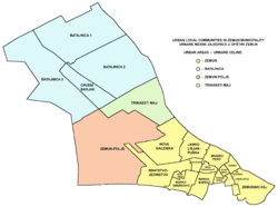
Zemunski Kej (Serbian Cyrillic: Земунски Кеј) is an urban neighborhood of Belgrade, the capital of Serbia. It is located in Belgrade's municipality of Zemun.
Location
Zemunski Kej, as its name suggests (Zemun's quay), is located alongside the right bank of the Danube. The promenade itself (officially named Kej Oslobođenja, Quay of Liberation) begins below the Gardoš hill, at the square of Veliki Trg and after 2, 5 kilometers it continues into the municipality of Novi Beograd. On the east it borders the neighborhoods of Donji Grad and Retenzija and on the south the neighborhood of Ušće in Novi Beograd.
Characteristics
For the most part, the promenade is parallel to the street opened for traffic. Near the beginning of the promenade is a one of major roundabouts in Zemun, with terminal bus stops for many public transportation bus lines (82, 85, 610, 611, 705). The promenade continues around Ušće and makes one continuous pedestrian path next to the neighborhoods of Staro Sajmište and Savski Nasip, alongside the left bank of the Sava. The high embankment with the promenade was built in 1967 so the Danube rarely flooded the quay (most notably in 1981). In September 2007 reconstruction of quay began including further elevation of the embankment, widening of the pedestrian path and construction another one on separate level, completion of the cycling path, etc. Works are expected to be finished in 2008.[1]
Zemunski Kej is the main Zemun's landing area for numerous boats. Also, as the bank (and thus the quay too) follows the line of the nearby Great War Island, it is the beginning point of the pontoon bridge which seasonally connects the island with the mainland.
Zemunski Kej makes a local community (mesna zajednica, municipal sub-administrative division) within the municipality of Zemun, with a population of only 3,649 by the 2002 census of population. This is because lots of area in the neighborhood are pedestrian paths or green areas used for recreation (including a large seasonal amusement park) and commercial facilities. The residential areas include blocks 9-a and 11-c. One of the largest hotels in Belgrade, "Hotel Jugoslavija" is located in the neighborhood, but it has been closed since the NATO bombing of Serbia in 1999 when it was badly damaged. It was opened partially in 2007 as the largest casino in Belgrade. The bank in front of the hotel is a location of many restaurants and clubs on barges (Serbian: splav), one of the focal points of the vibrant Belgrade's nightlife.
References
Coordinates: 44°50′36″N 20°25′02″E / 44.84333°N 20.41722°E