Zayanderud
| Zayandeh River Zayanderud | |
|---|---|
 Zayandeh River in Isfahan, Isfahan Province. | |
| Origin | Zagros Mountains |
| Mouth | Gavkhouni (endorheic) |
| Basin countries | Iran |
| Length | 400 km (249 mi) |
| Source elevation | 3,974 m (13,038 ft) |
| Mouth elevation | 1,466 m (4,810 ft) |
| Avg. discharge | 38 m³/s (1,342 cu ft/s) |
| Basin area | 41,500 km2 (16,020 sq mi) |
Zāyandé-Rūd or Zāyanderūd (Persian: زاینده رود, from زاینده [zɑːjændɛ] “life giver” and رود [rʊːd] “river”), also spelled as Zayandeh-Rood or Zayanderood, was the largest river in the central plateau of Iran. In the early 2010s, the river dried out completely after several years of seasonal dry-outs.
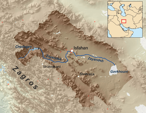
The Zayandeh started in the Zagros Mountains and flowed 400 kilometres (200 mi) eastward before ending in the Gavkhouni swamp, a seasonal salt lake, southeast of Isfahan city. The Zayandeh had significant flow all year long, unlike many of Iran's rivers which are seasonal. The Zayandeh river bed is spanned by many historical Safavid era bridges, and the river used to flow through many parks.
The Zayandeh River basin has an area of 41,500 square kilometres (16,000 sq mi), altitude from 3,974 metres (13,038 ft) to 1,466 metres (4,810 ft), an average rain fall of 130 millimetres (5 in) and a monthly average temperature of 3 °C (37 °F) to 29 °C (84 °F). There were 2,700 square kilometres (1,000 sq mi) of irrigated land in the Zayandeh River basin, with water derived from the nine main hydraulic units of the Zayandeh River, wells, qanat and springs in lateral valleys. Zayandeh River water gave life to the people of central Iran mainly in Isfahan and Yazd provinces. Before the drying-out, water diverted per person was 240 litres (63 US gallons/53 imp gallons) per day in urban and 150 litres (40 US gallons/33 imp gallons) per day in villages.[1] In the 1970s, the flow of the river was estimated at 1.2 cubic kilometres (0.29 cu mi) per annum, or 38 cubic metres (1,340 cu ft) per second.[2]
History
People have lived on the banks of Zayandeh River for thousands of years. The earliest evidence of human occupation along the River is found in a cave site called Qaleh Bozi near Dizicheh at SW of Isfahan. More than 40,000 years ago, groups of Paleolithic hunters (Neanderthals) used Qaleh Bozi caves as shelter for seasonal or temporary occupations and left their stone tools and bones of hunted animals. An ancient prehistoric culture, the Zayandeh River Civilization, flourished along the banks of the Zayandeh in the 6th Millennium BC.
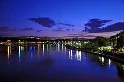
Zayandeh River crosses the city of Isfahan, a major cultural and economic center of Iran. In the 17th century, Shaikh Bahai (an influential scholar and adviser to the Safavid dynasty), designed and built a system of canals (maadi), to distribute Zayandeh water to Isfahan's suburbs. Water from the Zayandeh River helped the growth of the population and the economy, helped established Isfahan as an influential center, and gave a green landscape to Isfahan, a city in the middle of a desert.
Arthur Pope (an American archaeologist and historian of Persian art) and his wife Phyllis Ackerman are buried in a small tomb in pleasant surroundings in its banks. Richard Frye (an American scholar of Iranian and Central Asian Studies) has also requested to be buried there.[3]
Water use and division
Until the 1960s in Isfahan Province the distribution of water followed the Tomar, a document claimed to date from the 16th Century. The Tomar divided the flow of the Zayandeh River into 33 parts which were then specifically allotted to the eight major districts within the region.[4] At the district level the water flow was divided either on a time basis, or by the use of variable weirs, so that the proportion could be maintained regardless of the height of the flow.[4]
For centuries Isfahan city had been an oasis settlement, noted for its surrounding fertile lands and prosperity. Until the 1960s industrial demand for water was minimal, which enabled the scarce water resources to be utilized primarily for agriculture. With a growing population within the basin, and rising standards of living particularly within the city, the pressure on water resources steadily increased until the division of water Tomar was no longer feasible. The creation of large steel works and other new industries demanded water.[2]
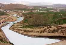
The Chadegan Reservoir dam project in 1972 was a major hydroelectric project to help with stabilizing water flow and generate electricity. The dam was initially named Shah Abbas Dam after Shah Abbas I, the most influential king of the Safavid dynasty, but it was changed to Zayandeh Dam after the Islamic revolution in 1979. Since 1972, the Chadegan Reservoir has helped prevent seasonal flooding of the Zayandeh River.
80% of the Zayandeh's extracted water was used for agriculture, 10% for human consumption (drinking and domestic needs of a population of 4.5 million), 7% for industry (like the Zobahan-e-Esfahan and Foolad Mobarekeh steel companies and Isfahan's petrochemical, refinery and power plants) and 3% for other uses. There have been a number of tunnel projects (Koohrang) to redirect water from the Karun river (Iran's largest river that also starts in the Zagros Mountains), to the Zayandeh. These have helped provide water for the growing population and new industries in both Isfahan and Yazd provinces.[5]
While the drying-out of the Zayandeh River has been attributed to drought, the main reasons are man-made. Poor planning and populist politics have led to years of mismanagement and overuse which resulted in seasonal dry-outs and ultimately caused the river to dry out completely.
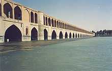
Bridges
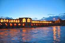
There are several new and old bridges (pol) over the Zayandeh River. The oldest, Shahrestan, built in the 5th century AD, is still in use as a pedestrian crossing in Sharestan village.
Bridges on Zayandeh River in City of Esfahan:
|
|
Recreation
In the section of the Zayandeh River crossing Esfahan, bridges, parks, paddle boats and traditional cafes and restaurants amongst the rest of Esfahan rich cultural heritage, are major tourist attractions for Iranian as well as international visitors.
External links
Notes
- ↑ "Zayandeh River Basin Short Profile" International Water Management Institute, Sri Lanka
- ↑ 2.0 2.1 Beaumont, Peter (October 1974) "Water Resource Development in Iran" The Geographical Journal 140(3): pp. 418-431, p. 427
- ↑ Staff (18 April 2005) "American Iranologist Wills wants to be Buried in Isfahan, Iran" Cultural Heritage News Agency Iran
- ↑ 4.0 4.1 Beaumont, Peter (October 1974) "Water Resource Development in Iran" The Geographical Journal 140(3): pp. 418-431, p. 421
- ↑ Assari, Ali; Erfan Assari (2012). "Urban spirit and heritage conservation problems: case study Isfahan city in Iran". Journal of American Science 8 (1): 203–209. Retrieved 7 January 2013.
| Wikimedia Commons has media related to Zayandeh Rud (Zayandeh River). |
Coordinates: 32°15′45″N 52°54′30″E / 32.26250°N 52.90833°E
| ||||||||||||||||||||||||||||||