Zala County
| Zala County | |||
|---|---|---|---|
 | |||
| |||
 | |||
| Country | Hungary | ||
| Region | Western Transdanubia | ||
| County seat | Zalaegerszeg | ||
| Area | |||
| • Total | 3,783.89 km2 (1,460.97 sq mi) | ||
| Population (2011 census) | |||
| • Total | 282,179 | ||
| • Density | 75/km2 (190/sq mi) | ||
| Website |
www | ||

Zala (Slovene: Zalska županija or županija Zala) is an administrative county (comitatus or megye) in south-western Hungary. It is named after the Zala River. It shares borders with Croatia and Slovenia and the Hungarian counties Vas, Veszprém and Somogy. The capital of Zala county is Zalaegerszeg. Its area is 3,784 square kilometres (1,461 sq mi). Lake Balaton lies partly in the county.
History

In the 10th century, the Hungarian Nyék tribe occupied the region around Lake Balaton. Their occupation was mainly in the areas known today as Zala and Somogy counties.[1]
Parts of the western territory of the former county of Zala are now part of Slovenia (South-Prekmurje). In 1919 it was part of the unrecognized state of the Republic of Prekmurje, which existed for just six days.
Regional structure
Cities with county rights
- Zalaegerszeg (county seat)
- Nagykanizsa
Cities and towns
(ordered by population, according to the 2001 census)
- Keszthely (21,944)
- Lenti (8,559)
- Zalaszentgrót (7,944)
- Letenye (4,613) from above
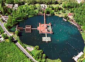
- Hévíz (4,523)
- Zalalövő (3,256)
- Pacsa (1,904)
- Zalakaros (1,519)
Villages
-

Vonyarcvashegy - Chapelle
-

Kemendollár-Kemen castle from above
-

Aerial Photography: Keszthely - Festetics Castle
-

Aerial Photo: Rezi - Castle
-

Aerial photography: Zalaegerszeg
| ||||||||||||
| ||||||||||||||
Coordinates: 46°40′N 16°50′E / 46.667°N 16.833°E
- ↑ Béla Kálmán, The world of names: a study in Hungarian onomatology, Akadémiai Kiadó, 1978, p. 134
| Wikimedia Commons has media related to Zala County. |