Zakynthos
| Zakynthos Περιφερειακή ενότητα / Δήμος Ζακύνθου | ||
|---|---|---|
| Regional unit | ||
|
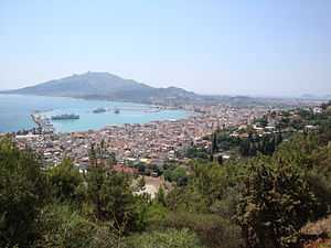
View of Zakynthos City | ||
| ||
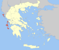
 Zakynthos within Greece | ||
| Coordinates: 37°48′N 20°45′E / 37.800°N 20.750°ECoordinates: 37°48′N 20°45′E / 37.800°N 20.750°E | ||
| Country | Greece | |
| Region | Ionian Islands | |
| Capital | Zakynthos (city) | |
| Government | ||
| • Vice Governor | Eleutherios Niotopoulos | |
| • Mayor | Pavlos Kolokotsas | |
| Area | ||
| • Total | 407.58 km2 (157.37 sq mi) | |
| Population (2011) | ||
| • Total | 40,759 | |
| • Density | 100/km2 (260/sq mi) | |
| Demonym | Zakynthian | |
| Postal codes | 29x xx | |
| Area codes | 2695 | |
| Car plates | ΖΑ | |
| Website |
www | |
Zakynthos (Greek: Ζάκυνθος [ˈzacinθos]) or Zante (/ˈzɑːnti, -teɪ, ˈzæn-/; from Venetian) is a Greek island in the Ionian Sea. It is the third largest of the Ionian Islands. Zakynthos is a separate regional unit of the Ionian Islands region, and its only municipality. It covers an area of 410 km2 (158 sq mi) and its coastline is roughly 123 km (76 mi) in length. The name, like all similar names ending in -nthos, is pre-Mycenaean or Pelasgian in origin. In Greek mythology the island was said to be named after Zakynthos, the son of a legendary Arcadian chief Dardanus.
Zakynthos is a tourist destination, with an international airport served by many charter flights from northern Europe. The island's nickname is To fioro tou Levante (Italian: Il fiore di Levante, English: The flower of the East), given by the Venetians.
History


Ancient history
Zakynthos was inhabited from the Neolithic Age, as some archaeological excavations have proved.
The ancient Greek poet Homer mentioned the island in the Iliad and the Odyssey, stating that the first inhabitants of it were the son of King Dardanos of Troy called Zakynthos and his men. In mythology the island was then conquered by King Arkesios of Kefalonia, and then by Odysseus from Ithaca.
Later on, a treaty was signed that made Zakynthos an independent democracy, the first established in Greece, that lasted more than 650 years.
The Athenian military commander Tolmides concluded an alliance with Zakynthus during the First Peloponnesian War sometime between 459 and 446 BC.[1][2] The importance of this alliance for Athens was that it provided them with a source of tar. Tar is a more effective protector of ship planking than pitch (which is made from pine trees). The Athenian trireme fleet needed protection from rot, decay and the teredo, so this new source of tar was valuable to them. The tar was dredged up from the bottom of a lake (now known as Lake Keri) using leafy myrtle branches tied to the ends of poles. It was then collected in pots and could be carried to the beach and swabbed directly onto ship hulls.[3] Alternatively, the tar could be shipped to the Athenian naval yard at the Piraeus for storage.[4]
Neapolitan and Venetian rule
During the Middle Ages, the island was part of the Byzantine theme of Cephallenia. After 1185 it became part of the County palatine of Cephalonia and Zakynthos under the Kingdom of Naples until its last Count Leonardo III Tocco was defeated by the Ottomans in 1479. The Turkish rule lasted only until 22 April 1484, when it was swapped with the Turks by Venetian secretary Giovanni Dario, negotiator of the treaty of Constantinople (1479), against neighboring Cephalonia and an annual tribute of 500 ducats.[5][6] From then on Zakynthos remained an overseas colony of the Venetian Republic until its very end in 1797, following the fate of the Ionian islands, completed by the capture of Cephalonia in 1500 and Lefkas in 1684 from the Turks.
Venetian rule protected the island from Ottoman domination but in its place it put a feudal oligarchy. The cultural influence of Venice (and of Venetian on local dialect) was considerable. The wealthy made a habit of sending their sons to Italy to be educated. Good examples are Dionysios Solomos, a native of Zakynthos and Greece's national poet, and Ugo Foscolo, also native of Zakynthos and a national Italian poet. However, both the Greek language and Orthodox faith survived intact. From the 16th to the 18th centuries, it was one of the largest exporters of currants in the world together with Cephalonia.
French, Ionian state period and British Rule
The Treaty of Campoformio dismantling the Venetian Republic awarded the Ionian Islands to France. General Antoine Gentili, leading a French expeditionary force with boats captured in Venice, took control of the islands on 26 June 1797. From 1797 to 1798, the island was part of the French départment Mer-Égée. A Russian-Turkish fleet captured the island on 23 October 1798. From 1800 to 1807, it was part of the Septinsular Republic, nominally under sovereignty of the Ottoman Empire but protected by Russia. In 1800–1801, Britain attempted to take control of the Ionian islands from Zakynthos after a revolt, under the leadership of James Callander Campbell[7] but these intentions stopped after the Peace of Amiens.[8][9][10] After a second period under French control (1807–1809) following the treaty of Tilsit, it was conquered by Great Britain on 16 October 1809, and was part of the British protectorate of the United States of the Ionian Islands from 1815 to 1864.
Union with Greece
In 1864, Zakynthos, together with all the other Ionian Islands, became a full member of the Greek state, ceded by Britain to stabilize the rule of the newly crowned Danish-born King of the Hellenes, George I.
During World War II
During the Nazi occupation of Greece, Mayor Karrer and Bishop Chrysostomos refused Nazi orders to turn in a list of the members of the town's Jewish community for deportation to the death camps. Instead they hid the town's 275 Jews in rural villages. Every Jew of Zakynthos survived the war. Statues of the Bishop and the Mayor commemorate their heroism on the site of the town's historic synagogue, destroyed in the earthquake of 1953. In 1978, Yad Vashem, the Holocaust Martyrs' and Heroes' Remembrance Authority in Israel, honored Bishop Chrysostomos and Mayor Loukas Karrer with the title of "Righteous among the Nations", an honor given to non-Jews who, at personal risk, saved Jews during the Holocaust. After the war, all of the Jews of Zakynthos moved either to Israel or to Athens.[11][12]
The Great Earthquake of 1953
The island suffered a series of four severe earthquakes in August 1953, resulting in the total destruction of its infrastructure, including most of the state archives. The third and most destructive of these quakes, registering 7.3 on the Richter Scale, occurred at 09:24 UTC (11:24 am local time) on 12 August 1953. It had its epicentre directly on the southern tip of the nearby island of Kefalonia, also causing widespread destruction there. The quake was felt throughout most of the country, and only three buildings on Zakynthos were left standing after the disaster: the St. Dionysios Cathedral, the National Bank building, and the church of St. Nicholas "tou Molou" (of the Quay). And other buildings in outlying areas managed to avoid complete collapse.

After the quake

After the enormous earthquake, the island's roads were expanded and paved along with the GR-35, one of the roads linking with the town and Porto Roma along with Laganas, Keri and Volimes and from Lachans to Keri, and its airport was opened in the 1960s. The island's population partly emigrated, but subsequently boomed in later years.
Mining is common on the island. A small mountain located in Zakynthos' west side was mined during the 1990s, though it is no longer in use. Today mining continues, but with two quarries on the mountain range on the western part of the island. Tourism continues to thrive and Zakynthos is currently one of the most popular tourist destinations in Greece.
A few earthquakes hit the island in the 2000s (decade), one on Sunday 8 June 2008 at 6.4 R, felt without any damage or injuries. Another less serious tremor occurred four months later on Saturday 11 October, measured at 4R and also causing almost no damage.
The April 2006 earthquake swarm
Starting in the early morning hours of 4 April 2006, a series of moderate to strong earthquakes occurring on an almost daily basis began shaking almost the entire island. On 11 April, however, the phenomenon intensified in both magnitude and rate of events. At 03:02 local time of that day, a powerful, magnitude 5.7 earthquake hit the area, only to be followed by an even stronger tremor, registering 5.9 on the Richter Scale, at 8:30 p.m. (20:30) EET. On 12 April, a committee of the nation's most prominent seismologists had an emergency meeting with the Greek Ministry of Environment, Physical Planning and Public Works, in order to assess the emerging situation. The meeting ended in a scientific consensus that this specific area of the Ionian Sea was simply not ready to produce an even stronger quake, advising the nervous citizens of the island to remain calm. However, at 19:52 and at 19:56 local time of that same evening, two more earthquakes shook the region, sending scores of terrified people into the streets. The earthquakes had a preliminary moment magnitude of 5.8 and 5.4 respectively. Seismologists at the Athens Seismological Institute were once again taken by surprise by what turned into an unprecedented riddle concerning whether or not these were in fact foreshocks of a major event. The chances are, nonetheless, that this was just a phenomenon known as earthquake swarm, characterized by a pattern of a considerable amount of magnitude-wise similar tremors, all occurring within a limited number of days or weeks. As a result of the recurring jolts, moderate damage was reported to a total of sixty residencies and one library, while a small crack appeared on the eastern part of the capital's port. In addition, several rocks tumbled down onto one of the island's main roads, running through its mountainous areas.
The Ionian Islands are situated upon one of Europe's most notorious faults, capable of producing earthquakes potentially causing both widespread damage and considerable loss of life. However it should be stressed that, following the catastrophe of 1953, the authorities of Zakynthos have enforced a strict program of antiseismic standards (the same applies to the rest of Greece) to be applied in every building to be constructed. All buildings have been built on a swimming slab and enforced with steel, determined by the government to ensure safety.
After the quake and the Wildfires of 2006
On Thursday 18 July 2006, the western portion of the island was hit by a forest fire. The fire spread to the island's forest and ended up spreading by hectares. Firefighters along with helicopters and planes from the mainland arrived to fight the fire's expansion and further deforestation. The fire lasted for several days and on 20 July, much of the area was contained; though it had become unpopular and unattractive scenery. One of the conflagrations appeared as a fiery line visible from as far away as the southern portion of the island and the Ionian Sea.
Geography

Zakynthos lies in the eastern part of the Ionian sea, around 20 kilometres (12 miles) west of the Greek (Peloponnese) mainland. Island of Kefalonia lies 15 kilometres (9 miles) on the north. It is the southernmost of the main group of the Ionian islands (not counting distant Kythira). Zakynthos is about 40 kilometres (25 miles) long and 20 kilometres (12 miles) wide, and covers an area of 410 km2 (158 sq mi). Its coastline is approximately 123 km (76 mi) long. According to the 2011 census, the island has a population of 45,650. The highest point is Vrachionas, at 758 m.
Zakynthos has the shape of an arrowhead, with the "tip" (Cape Skinari) pointing northwest. The western half of the island is a mountainous plateau and the southwest coast consists mostly of steep cliffs. The eastern half is a densely populated fertile plain with long sandy beaches, interrupted with several isolated hills, notably Bochali which overlooks the city and the peninsula of Vasilikos in the northeast. The peninsulas of Vassilikos on north and Marathia on south enclose the wide and shallow bay of Laganas on the southeast part of the island.
The capital, which has the same name as the prefecture, is the town of Zakynthos. It lies on the eastern part of the northern coast. Apart from the official name, it is also called Chora (i.e. the Town, a common denomination in Greece when the name of the island itself is the same as the name of the principal town). The port of Zakynthos has a ferry connecting to the port of Kyllini on the mainland. Another ferry connects the village of Agios Nikolaos to Argostoli on Kefalonia.
Minor uninhabited islands around Zakynthos included in the municipality and regional unit are: Marathonisi, Pelouzo, Agios Sostis in the Laganas bay; Agios Nikolaos, near the eponymous harbor on the northern tip; and Agios Ioannis near Porto Vromi on the western coast.
Flora and fauna
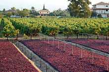
The mild, Mediterranean climate and the plentiful winter rainfall endow the island with dense vegetation. The principal products are olive oil, currants, grapes, and citrus fruit. The Zante currant is a small sweet seedless grape which is native to the island.
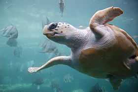
Bay of Laganas is the site of the first National Marine Park and the prime nesting area for loggerhead sea turtles (Caretta caretta) in the Mediterranean. In the early 1980s, the Bay of Laganas was seriously threatened as a nesting habitat, but thanks to the efforts of MEDASSET founder and president Lily Venizelos it could be preserved. Caretta caretta is an endangered species – especially by the deck chairs laid out on their breeding grounds and the inevitable pollution. Every year at the beginning of June, the female turtles come to the southern beaches in order to bury their eggs in the sand.[13] The incubation period for the nest is approximately fifty-five days, after which time hatchlings emerge from the nest and make their way to the sea. The survival rate for hatchlings is very small, and it is estimated that only one in one thousand hatchlings that enter the sea lives to adulthood. Each nest contains around one hundred to one hundred and twenty eggs, each of which are around the size and shape of a ping-pong ball. Female turtles begin to lay nests at around twenty to thirty years of age.
Climate
| Climate data for Zakynthos (1961–1990) | |||||||||||||
|---|---|---|---|---|---|---|---|---|---|---|---|---|---|
| Month | Jan | Feb | Mar | Apr | May | Jun | Jul | Aug | Sep | Oct | Nov | Dec | Year |
| Record high °C (°F) | 20.2 (68.4) |
21.4 (70.5) |
24.2 (75.6) |
25.6 (78.1) |
34.2 (93.6) |
35.8 (96.4) |
42.2 (108) |
38.4 (101.1) |
36.8 (98.2) |
30.4 (86.7) |
26.6 (79.9) |
22.2 (72) |
42.2 (108) |
| Average high °C (°F) | 14.4 (57.9) |
14.5 (58.1) |
16.1 (61) |
18.9 (66) |
23.4 (74.1) |
27.8 (82) |
30.7 (87.3) |
30.6 (87.1) |
27.6 (81.7) |
23.0 (73.4) |
19.0 (66.2) |
15.8 (60.4) |
21.8 (71.2) |
| Daily mean °C (°F) | 11.3 (52.3) |
11.5 (52.7) |
12.9 (55.2) |
15.5 (59.9) |
19.8 (67.6) |
24.1 (75.4) |
26.7 (80.1) |
26.6 (79.9) |
23.8 (74.8) |
19.6 (67.3) |
15.8 (60.4) |
12.8 (55) |
18.4 (65.1) |
| Average low °C (°F) | 8.1 (46.6) |
8.2 (46.8) |
9.2 (48.6) |
11.1 (52) |
14.4 (57.9) |
18.2 (64.8) |
20.4 (68.7) |
20.9 (69.6) |
18.8 (65.8) |
15.7 (60.3) |
12.5 (54.5) |
9.6 (49.3) |
13.9 (57) |
| Record low °C (°F) | −2.6 (27.3) |
−2.0 (28.4) |
0.0 (32) |
2.6 (36.7) |
5.0 (41) |
8.4 (47.1) |
12.0 (53.6) |
13.4 (56.1) |
10.8 (51.4) |
5.2 (41.4) |
2.8 (37) |
0.2 (32.4) |
−2.6 (27.3) |
| Average precipitation mm (inches) | 150.4 (5.921) |
112.8 (4.441) |
89.6 (3.528) |
51.3 (2.02) |
17.0 (0.669) |
7.2 (0.283) |
5.0 (0.197) |
9.1 (0.358) |
25.4 (1) |
146.5 (5.768) |
159.1 (6.264) |
169.9 (6.689) |
943.3 (37.138) |
| Avg. precipitation days (≥ 1.0 mm) | 12.8 | 11.3 | 8.2 | 6.1 | 2.5 | 1.1 | 0.5 | 0.9 | 2.8 | 8.1 | 11.0 | 13.2 | 78.5 |
| Average relative humidity (%) | 74.3 | 72.8 | 72.8 | 71.7 | 67.8 | 62.8 | 59.3 | 61.2 | 66.7 | 71.7 | 76.0 | 75.3 | 69.4 |
| Source: NOAA[14] | |||||||||||||
Sights
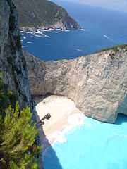
The most famous landmark of the island is the Navagio beach. It is a cove on the southwest shore, isolated by high cliffs and accessible only by boat. The beach and sea floor are made of white pebbles, and surrounded by turquoise waters. It is named after a shipwreck (MV Panagiotis), which sunk on the shore around 1980. The ridge area from Anafonitria has a small observation deck which overlooks the shipwreck, and there is a monastery nearby. The unique and stunning visuals of the location are a favourite for BASE jumpers, and each year a major event in the BASE calendar is held at Navagio, around the end of August.
Numerous "Blue Caves", are cut into cliffs around Cape Skinari, and accessible only by small boats. Sunrays reflect through blue sea water from white stones of cave bottoms and walls, creating visual lighting effects.[15] Keri is located in the far south of the island. It is a mountain village and has a lighthouse in the south. It includes a panorama of the southern part of the Ionian Sea. The whole western shore from Keri to Skinari contains numerous interesting rock formations, including arches.[16]

Northern and eastern shores feature numerous wide sandy beaches, some of which are attract tourists in summer months. The largest resort is Laganas, whose beach stretches around 10 kilometres (6 miles). Small Xigia beach in the north is noted for its underwater springs rich in sulphur, giving a distinct odour.[16] Marathonissi islet (also known as "Turtle Island") near Limni Keriou contains tropical vegetation, turquoise waters, beaches, and sea caves.
Bochali hill above the Zakynthos town contains a small Venetian castle and offers panoramic views of the town. Located next to Bochali, Strani hill is the place where Dionysios Solomos wrote the Greek national anthem.[17]
Administration
Zakynthos is a separate regional unit of the Ionian Islands region, and the only municipality of the regional unit. The seat of administration is Zakynthos (city), the main town of the island.
Prefecture
As a part of the 2011 Kallikratis government reform, the regional unit Zakynthos was created out of the former prefecture Zakynthos (Greek: Νομός Ζακύνθου). The prefecture had the same territory as the present regional unit. At the same reform, the current municipality Zakynthos was created out of the 6 former municipalities:[18]
Population and demographics
- 1889: 44,070 (island), 18,906 (city)
- 1896: 45,032 (island), 17,478 (city)
- 1900: 42,000
- 1907: 42,502
- 1920: 37.482
- 1940: 42,148
- 1981: 30,011
- 1991: 32,556 (island), 13,000 (city)
- 2001: 38,596
- 2011: 40,759
In 2006, there were 507 births and 407 deaths.[19] Zakynthos is one of the regions with the highest population growth in Greece. It is also one of the only three prefectures (out of 54) in which the rural population has a positive growth rate. In fact, the rural population's growth rate is higher than that of the urban population in Zakynthos. Out of the 507 births, 141 were in urban areas and 366 were in rural areas. Out of the 407 deaths, 124 were in urban areas and 283 were in rural areas.
The population of Zakynthos suffers from an exceptionally high rate of blindness of about 1.8%. That rate is about nine times the average in Europe, according to the WHO. In April 2012 the Greek Ministry of Health and Social Solidarity launched an investigation into disability benefits for the blind.[20]
Culture

The island has a long musical tradition. It was a precursor of opera and operetta in Greece and on the island it constituted links between nobles and the rest of the people. In 1815 it saw the establishment of the first Music School in Greece. During the first Olympic Games (Athens 1896), the Music Band of Zakynthos took part in the event. It was the period when composers of Zantiote origin, such as Domeneginis Kapnissis, enjoyed some fame in Europe. Inaugurated in 2009, Zakynthos also now has its own Zante Jazz Festival.
The novel Among the Olive Groves by Chrissie Parker is primarily set on the island of Zakynthos.
Museums

There are two museums located in Zakynthos town: the Byzantine Museum of Zakynthos, featuring renaissance paintings, Byzantine icons and more; and the Museum of Solomos and Eminent People of Zakynthos, hosting the mausoleum of Dionysios Solomos and Andreas Kalvos, as well as works by many eminent Zakynthians.
Sport
The island offers exceptional attractions for scuba divers. Caves around the island attract numerous divers. A wide range of marine life can be found, common amongst being moray eels, monk seals, octopus, and loggerhead turtles (caretta caretta).
Zakynthos F.C. is the football club of the island.
Transportation

The island is covered by a dense network of asphalt roads, particularly the flat eastern part. Main routes link the town with Volimes on north, Keri on the south, and peninsula Vassiliki on the west. The road between Volimes and Lithakia is the spine of the western half of the island.
The island has one airport, Zakynthos International Airport, "Dionysios Solomos" (on former GR-35) which connects flights with other Greek airports and numerous touristic charters. It is located near Laganas.
Zakynthos also features two ports: the main port, located in the Zakynthos town, and another in the village of Agios Nikolaos. From the main port there is a connection to the port of Kyllini, which is the usual route for arrivals to the island by sea from the mainland. From the port of Agios Nikolaos there is a connection to the island of Kefalonia (port of Pesada).
Science
Since 2003 Zakynthos possesses two academic departments belonging to the Technological Educational Institute of Ionian Islands.[21] The first of which is the department of Environmental Technology and Ecology[22] where environmental technologies, atmospheric physics, chemistry, climate dynamics, renewable energy sources, environmental management, biodiversity, and ecosystems dynamics are developed from the basis of natural sciences and mechanics. The department's sections have developed significant laboratory and field station infrastructures along Zakynthos and the Strofades islets. The second department is that of Protection and Conservation of Cultural Heritage.[23]
The freshwater resources on Zakynthos are limited, and as a result a Greek-Norwegian educational collaboration is being established on the island. The Science Park Zakynthos is a collaboration between the Technological Educational Institute of the Ionian Islands (TEI), The Norwegian University of Life Sciences (UMB), and the Therianos Villas and Therianos Family Farm on Zakynthos.
Notable people
_statue%2C_Zakynthos_City%2C_Greece_01.jpg)
Among the most famous Zakynthians is the 19th-century poet Dionysios Solomos whose statue adorns the main town square. The Italian poet Ugo Foscolo was also born in Zakynthos.
- Dionysios of Zakynthos (c. 16th century) a Saint of the Orthodox Church.
- Ιoannes Demisianos (c. 16th century), mathematician.
- Nikolaos Koutouzis (1741–1813), painter
- Ugo Foscolo (1778–1827), Italian poet and writer
- Andreas Kalvos (1789–1869), poet
- Dionysios Solomos (1798–1857), poet and writer of the Greek national anthem
- Pavlos Carrer (1829–1896), composer
- Leonidas Zois (1865–1956), historian
- Gregorios Xenopoulos (1867–1951), writer-journalist
- George Costakis (1913–1990), art collector
- Demetrios Kaparis (born 1935), naval architect/engineer
- Kostas Dikefalos (born 1956), sculptor
- Dionysios Vertzagias (born 1970), school professor and preserver of Zakynthian culture
Gallery
-

Inside the Cathedral of Saint Dionysios
-

Parish church in Loúcha
-

Bust of Ugo Foscolo
-

Belltower in the village of Macherado
-

Agia Analipsi church, Zakynthos city
-

Strofades monastery
-

Agios Nikolaos church, Zakynthos city
-

Kiria ton Angelon, Zakynthos city
See also
References
- ↑ Thucydides. History of the Peloponnesian War. Richard Crawley (trans.). 2.8. Retrieved 24 July 2010.
- ↑ Diodorus Siculus (1946). Library of History 4. C. H. Oldfather (trans.). Loeb Classical Library. 11.84.7. ISBN 978-0-674-99413-3. Retrieved 24 July 2010.
- ↑ Herodotus (1910). History of Herodotus. George Rawlinson (trans.). 4.195. Retrieved 24 July 2010.
- ↑ Hale, John (2009). Lords of the Sea: The Epic Story of the Athenian Navy and the Birth of Democracy. New York: Viking. p. 107. ISBN 978-0-670-02080-5.
- ↑ Meyer Setton, Kenneth (1978). The Papacy and the Levant, 1204–1571: The fifteenth century. Volume 2. American Philosophical Society. pp. 341, 515. ISBN 978-0-87169-127-9. Retrieved 16 June 2011.
- ↑ Leo, Heinrich; Botta, Carlo (1856). Dochez, Louis, ed. Histoire d'Italie: depuis les premiers temps jusqu'à nos jours [History of Italy: from the oldest times till nowadays] (in French). Volume 1. Paris: Adolphe Delahays. p. 600. Retrieved 16 June 2011.
- ↑ Sir James Callander Campbell, Knight of Ardkinglass (1745–1832), Council (?) in Zante in 1801, not to be confused with James Campbell (1763–1819), military governor of Corfu in 1814–1816
- ↑ Campbell, Sir James (1832). "Chapter XVI: (...) The Ionian Islands (...)". Memoirs of Sir James Campbell, of Ardkinglas. Volume 1. London: Henry Colburn & Richard Bentley. pp. 379 et seq. OCLC 04662979. Retrieved 13 May 2011.
- ↑ —— (1832). "Chapter I: Progress of the Author's Commission in the Ionian Isles". Memoirs of Sir James Campbell, of Ardkinglas. Volume 2. London: Henry Colburn & Richard Bentley. OCLC 4662979. Retrieved 13 May 2011.
- ↑ Great Britain Foreign Office (Hrsg.): British and Foreign State Papers 1849–1850 (2). Vol. XXXIX. Harrison & Sons, London 1863. S. 623.
- ↑ Dionyssios Stravolemos, An Act of Heroism – A Justification
- ↑ LEORA GOLDBERG. "The miraculous story of the Jews of Zakynthos". ZAKYNTHOS, Greece: THE JERUSALEM POST.
- ↑ "Park Area". Zakynthos Marine Park.
- ↑ "Zakinthos Airport Climate Normals 1961-1990". National Oceanic and Atmospheric Administration. Retrieved March 2, 2015.
- ↑ "Zakynthos Blue Caves: The Blue Caves of Zakynthos Greece, Ionian".
- ↑ 16.0 16.1 Carole Simm. "Beaches in Zakynthos, Greece". USA Today Travel.
- ↑ http://www.presidency.gov.cy/presidency/presidency.nsf/prc34_gr/prc34_gr?OpenDocument
- ↑ Kallikratis reform law text PDF
- ↑
- ↑ Angelos, James (3 April 2012). "'Island of the Blind' Riles a Greek Public Facing Cutbacks". The Wall Street Journal.
- ↑ teiion.gr
- ↑ envi.teiion.gr
- ↑ culture.teiion.gr
External links
| Wikimedia Commons has media related to Zakynthos. |
- Science Park Zakynthos – Greek-Norwegian educational and research collaboration on Zakynthos
- Zakynthos Map
- Zante Travel Map
- The rescue of the Jews of Zakyntos during World War II
| ||||||||||||||||||||||||||||||||||
| ||||||||||||||||||||||||||
| ||||||||||
