Zakroczym
| Zakroczym | ||
|---|---|---|
|
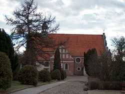
Church in Zakroczym | ||
| ||
 Zakroczym | ||
| Coordinates: 52°26′16″N 20°36′43″E / 52.43778°N 20.61194°ECoordinates: 52°26′16″N 20°36′43″E / 52.43778°N 20.61194°E | ||
| Country |
| |
| Voivodeship | Masovian | |
| County | Nowy Dwór Mazowiecki | |
| Gmina | Zakroczym | |
| Established | 11th century | |
| Town rights | 1422 | |
| Government | ||
| • Mayor | Henryk Ruszczyk | |
| Area | ||
| • Total | 19.97 km2 (7.71 sq mi) | |
| Elevation | 67 m (220 ft) | |
| Population (2006) | ||
| • Total | 3,367 | |
| • Density | 170/km2 (440/sq mi) | |
| Time zone | CET (UTC+1) | |
| • Summer (DST) | CEST (UTC+2) | |
| Postal code | 05-170 | |
| Area code(s) | +48 22 | |
| Car plates | WND | |
| Website | http://www.zakroczym.pl | |
Zakroczym [zaˈkrɔt͡ʂɨm] is a small town in the Masovian Voivodeship, Poland. It is located at around 52°26′16″N 20°36′43″E / 52.43778°N 20.61194°E. The Vistula River flows through the town. Zakroczym has a long and rich history: in the Kingdom of Poland and the Polish-Lithuanian Commonwealth, it was the capital of an administrative unit (ziemia), part of Mazovian Voivodeship. Also, Zakroczym was a royal town of the Crown of the Kingdom of Poland. The town lies at the intersection of two main roads - national road 62, and national road 7.
Name
The name of Zakroczym comes from ancient Polish word zakrot, which means river crossing. Originally, the town was located closer to the Vistula river, and was called Kroczym or Kroczyn. Due to numerous floods, Zakroczym was moved to a higher location.
History
- c. 1155 - first mention of the gord and settlement of Zakroczym, property of Benedictine Monastery from Mogilno,
- June 8, 1335. Mazovian dukes Siemowit II and Trojden I renew here truce with Grand Master of the Teutonic Knights, Dietrich von Altenburg,
- 1374 - Zakroczym becomes capital of a land, part of Mazovian Voivodeship, and remains so until 1795,
- 1422 - Duke of Mazovia Janusz I of Warsaw grant town charter to Zakroczym,
- 1656-1657 - Zakroczym is occupied by Swedish forces (see Swedish invasion of Poland). The town is partially destroyed,
- 1709 - Zakroczym is burned by Swedish troops during the Great Northern War,
- 1757 - construction of a monastery Order of Friars Minor Capuchin begins,
- 1793 - the town is seized by the Russians (see Partitions of Poland),
- 1795 - Zakroczym becomes part of the Kingdom of Prussia,
- 1806 - Napoleon’s forces cross the Vistula near Zakroczym, before the Battle of Pultusk,
- 1815 - Zakroczym becomes part of Congress Poland,
- 1831 - after Russian capture of Warsaw, meetings of Polish government and Sejm take place at the monastery,
- 1883-1888 - construction of Fort 1 Zakroczym, first ring of fortifications of the Modlin Fortress,
- August 20, 1915 - Russian garrison of the fortress capitulates to Germans,
- September 10-28, 1939 - Battle of Modlin,
- 1944 - Germans create a transit camp for 30,000 residents of Warsaw, deported from the city after the Warsaw Uprising. 78% of Zakr
- 1945 - as a result of World War Two, 78% of the town is destroyed.
Sights
- parish church (15th or 16th century), rebuilt in 1949. In its northern and southern walls there are Swedish cannonballs,
- Baroque Capuchin church and monastery,
- a monument dedicated to rebels of 1830 and 1863, and to victims of the war,
- castle hill, with a 19th-century manor house, built on 15th-century foundations. Original manor house was built before 1422 by Mazovian dukes,
- traces of an 11th-century gord, located northeast of town, on a high bank of the Vistula. The gord, first mentioned in 1065, was burned in late 13th century, and later rebuilt.
- Fort Nr. 1 Zakroczym (1883-1888).
External links
- Jewish Community in Zakroczym on Virtual Shtetl
| ||||||||||||