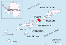
Zahari Point


Zahari Point (Nos Zahari \'nos za-'ha-ri\) is an ice-free point on the southwest coast of Robert Island in the South Shetland Islands, Antarctica forming the northwest side of the entrance to Micalvi Cove. Ice-free surface area 21 hectares (52 acres).[1] The feature is named after the Bulgarian writer and historiographer Zahari Stoyanov (1850–1889).
Location
The point is located at 62°26′58″S 59°32′08″W / 62.44944°S 59.53556°WCoordinates: 62°26′58″S 59°32′08″W / 62.44944°S 59.53556°W, which is 6.8 km southeast of Negra Point, 1.8 km east-southeast of Beron Point, and 2 km northwest of Edwards Point (British mapping in 1968, and Bulgarian in 2005 and 2009).
Map
- L.L. Ivanov et al. Antarctica: Livingston Island and Greenwich Island, South Shetland Islands. Scale 1:100000 topographic map. Sofia: Antarctic Place-names Commission of Bulgaria, 2005.
Notes
- ↑ L.L. Ivanov. Antarctica: Livingston Island and Greenwich, Robert, Snow and Smith Islands. Scale 1:120000 topographic map. Troyan: Manfred Wörner Foundation, 2009. ISBN 978-954-92032-6-4
References
This article includes information from the Antarctic Place-names Commission of Bulgaria which is used with permission.