Yzeure
| Yzeure | ||
|---|---|---|
|
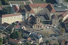
An aerial view of the church and surroundings in Yzeure | ||
| ||
 Yzeure | ||
|
Location within Auvergne region  Yzeure | ||
| Coordinates: 46°34′01″N 3°21′19″E / 46.5669°N 3.3553°ECoordinates: 46°34′01″N 3°21′19″E / 46.5669°N 3.3553°E | ||
| Country | France | |
| Region | Auvergne | |
| Department | Allier | |
| Arrondissement | Moulins | |
| Canton | Yzeure | |
| Intercommunality | Moulins | |
| Government | ||
| • Mayor (2008–2014) | Guy Chambefort | |
| Area1 | 43.24 km2 (16.70 sq mi) | |
| Population (2008)2 | 12,515 | |
| • Density | 290/km2 (750/sq mi) | |
| INSEE/Postal code | 03321 / 03400 | |
| Elevation |
217–278 m (712–912 ft) (avg. 239 m or 784 ft) | |
|
1 French Land Register data, which excludes lakes, ponds, glaciers > 1 km² (0.386 sq mi or 247 acres) and river estuaries. 2 Population without double counting: residents of multiple communes (e.g., students and military personnel) only counted once. | ||

Yzeure is a commune in the department of Allier in Auvergne in central France.
Demographics
| Historical population | ||
|---|---|---|
| Year | Pop. | ±% |
| 1962 | 10,000 | — |
| 1968 | 11,665 | +16.7% |
| 1975 | 13,715 | +17.6% |
| 1982 | 13,197 | −3.8% |
| 1990 | 13,461 | +2.0% |
| 1999 | 12,969 | −3.7% |
| 2008 | 12,515 | −3.5% |
See also
References
| Wikimedia Commons has media related to Yzeure. |