Yvoir
| Yvoir | |
|---|---|
| Municipality | |
 | |
 Yvoir Location in Belgium | |
|
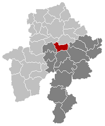
Location of Yvoir in Namur province  | |
| Coordinates: 50°20′N 04°53′E / 50.333°N 4.883°ECoordinates: 50°20′N 04°53′E / 50.333°N 4.883°E | |
| Country | Belgium |
| Community | French Community |
| Region | Wallonia |
| Province | Namur |
| Arrondissement | Dinant |
| Government | |
| • Mayor | Ovide Monin |
| • Governing party/ies | LB 2006 |
| Area | |
| • Total | 56.84 km2 (21.95 sq mi) |
| Population (1 January 2013)[1] | |
| • Total | 8,882 |
| • Density | 160/km2 (400/sq mi) |
| Postal codes | 5530 |
| Area codes | 082 |
| Website | www.yvoir.be |
Yvoir (French pronunciation: [i.vwaʁ]) is a Walloon municipality located in the Belgian province of Namur. On 1 January 2006 the municipality had 8,450 inhabitants. The total area is 56.84 km², making it a population density of 149 inhabitants per km². The municipality consists of the villages Dorinne, Durnal, Evrehailles, Godinne, Houx, Mont, Purnode, Spontin and Yvoir.
Sport
Yvoir was the host city of the 1975 UCI Road World Championships
References
- ↑ Population per municipality on 1 January 2013 (XLS; 607.5 KB)
External links
- Official website (in French)

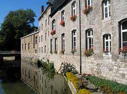
Yvoir, the Bocq river alongside the south wing of the communal house.
| ||||||||||||||||
