Yuryaku Seamount
| Yuryaku Guyot | |
|---|---|
|
Bathymetric mapping of Yuryaku | |
|
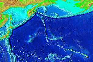
Elevation of the Pacific seafloor, showing the Hawaiian-Emperor seamount chain, including Yuryaku Seamount a bit off of the V. The sharp "V" separates the Hawaiian Ridge from the older Emperor Seamount portion of the chain. Yuryaku is the center/northernmost and most elongated of the small grouping of three fairly small volcanoes near the bend. | |
| Location | |
| Group | Emperor seamounts |
| Coordinates | 32°40.20′N 172°16.2′E / 32.67000°N 172.2700°ECoordinates: 32°40.20′N 172°16.2′E / 32.67000°N 172.2700°E[1] |
| Geology | |
| Type | Guyot, Hotspot volcano |
| Volcanic arc/chain | Hawaiian-Emperor seamount chain |
| Last eruption | 43 million years ago |
Yuryaku Seamount (also called Yuryaku Guyot) is a seamount (underwater volcano) and guyot (flat-topped) located northwest of Hawaii. It is located a little southwest of the V-shaped bend separating the Emperor Seamounts from the older Hawaiian islands in the Hawaiian-Emperor seamount chain, in the North Pacific. Alkalic basalt dredged from Yuryaku Seamount is similar to the alkalic basalt that caps the volcanoes in the Hawaiian Islands. Analyses gave a mean age of 42.3 ± 1.6 m.y. for Yuryaku Seamount.[2] The data collected helped show that the age of the Hawaiian-Emperor bend is about 41 to 43 m.y. Alkalic basalt have been sampled at Yuryaku Seamount. The last eruptions of Yuryaku Seamount was 43 million years ago.[3]
References
- ↑ "Seamount Catalog". Seamounts database. EarthRef, a National Science Foundation project. Retrieved 2009-04-10.
- ↑ Clague, D.A., Dalrymple, G.B. and Moberly, R. (1975). "Petrography and K-Ar ages of dredged volcanic rocks from the western Hawaiian Ridge and the southern Emperor Seamount Chain". Society of America, Bulletin 86(7). The Geological Society of America. pp. 991–998. Retrieved 2009-04-11.
- ↑ Seach, John. "Yuryaku Seamount - John Seach". Volcanic database. volcanolive.com. Retrieved 2009-04-11.
| ||||||||||||||||||||

