Yukon
| Yukon (formerly Yukon Territory) | |||||
| |||||
| Motto: No official motto | |||||
| Capital | Whitehorse | ||||
|---|---|---|---|---|---|
| Largest city | Whitehorse | ||||
| Largest metro | Whitehorse | ||||
| Official languages | English, French | ||||
| Demonym | Yukoner | ||||
| Government | |||||
| Type | |||||
| Commissioner | Doug Phillips | ||||
| Premier | Darrell Pasloski (Y) | ||||
| Legislature | Yukon Legislative Assembly | ||||
| Federal representation | (in Canadian Parliament) | ||||
| House seats | 1 of 308 (0.3%) | ||||
| Senate seats | 1 of 105 (1%) | ||||
| Confederation | June 13, 1898 (9th) | ||||
| Area | Ranked 9th | ||||
| Total | 482,443 km2 (186,272 sq mi) | ||||
| Land | 474,391 km2 (183,163 sq mi) | ||||
| Water (%) | 8,052 km2 (3,109 sq mi) (1.7%) | ||||
| Proportion of Canada | 4.8% of 9,984,670 km2 | ||||
| Population | Ranked 12th | ||||
| Total (2011) | 33,897 [1] | ||||
| Density (2011) | 0.07/km2 (0.18/sq mi) | ||||
| GDP | Ranked 12th | ||||
| Total (2011) | C$2.660 billion[2] | ||||
| Per capita | C$75,141 (3rd) | ||||
| Abbreviations | |||||
| Postal | YT | ||||
| ISO 3166-2 | CA-YT | ||||
| Time zone | UTC-8 | ||||
| Postal code prefix | Y | ||||
| Flower | Fireweed | ||||
| Tree | Subalpine Fir[3] | ||||
| Bird | Common Raven | ||||
| Website | www.gov.yk.ca | ||||
| Rankings include all provinces and territories | |||||


Yukon[4] /ˈjuːkɒn/ (also commonly called the Yukon) is the westernmost and smallest of Canada's three federal territories. Whitehorse is the territorial capital and Yukon's only city.
The territory was split from the Northwest Territories in 1898. The federal government's Yukon Act, which received royal assent on March 27, 2002, confirmed "Yukon" as the standard, though "Yukon Territory" remains the more popular usage.[4] Though officially bilingual (English and French), the Yukon Government also recognizes First Nations languages.
At 5,959 m (19,551 ft), Yukon's Mount Logan, in Kluane National Park and Reserve, is the highest mountain in Canada and the second-highest on the North American continent (after Mount McKinley in the U.S. state of Alaska). The territory's climate is Arctic in the north (north of Old Crow), subarctic in the central region, between north of Whitehorse and Pie Town, and has a humid continental climate in the far south, south of Whitehorse and in areas close to the British Columbia border. Several rivers run through Yukon, some being the Stewart River, Peel River, and the Yukon River, after which the territory was named.
 Downtown Whitehorse along the Yukon River |
History
Long before the arrival of Europeans, central and southern Yukon was populated by First Nations people, and the area escaped glaciation. The volcanic eruption of Mount Churchill in approximately 800 AD in the U.S. state of Alaska blanketed southern Yukon with a layer of ash which can still be seen along the Klondike Highway and forms part of the oral tradition of First Nations peoples in Yukon and further south.
Coastal and inland First Nations had extensive trading networks. European incursions into the area only began early in the 19th century with the fur trade, followed by missionaries and the Western Union Telegraph Expedition. By the 1870s and 1880s gold miners began to arrive. This drove a population increase that justified the establishment of a police force, just in time for the start of the Klondike Gold Rush in 1897. The increased population coming with the gold rush led to the separation of the Yukon district from the Northwest Territories and the formation of the separate Yukon Territory in 1898. Sites of archeological significance in Yukon hold some of the earliest evidence of the presence of human occupation in North America.[5] The sites safeguard the history of the first people and the earliest First Nations of the Yukon.[5]
Geography
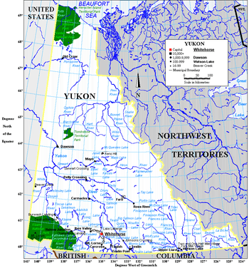
The territory is the approximate shape of a right triangle, bordering the U.S. state of Alaska to the west for 1,210 km (752 mi) mostly along longitude 141° W, the Northwest Territories to the east and British Columbia to the south.[6] Its northern coast is on the Beaufort Sea. Its ragged eastern boundary mostly follows the divide between the Yukon Basin and the Mackenzie River drainage basin to the east in the Mackenzie mountains.
Most of the territory is in the watershed of its namesake, the Yukon River. The southern Yukon is dotted with a large number of large, long and narrow glacier-fed alpine lakes, most of which flow into the Yukon River system. The larger lakes include Teslin Lake, Atlin Lake, Tagish Lake, Marsh Lake, Lake Laberge, Kusawa Lake and Kluane Lake. Bennett Lake on the Klondike Gold Rush trail is a lake flowing into Nares Lake, with the greater part of its area within Yukon.
Canada's highest point, Mount Logan (5,959 m or 19,551 ft), is in the territory's southwest. Mount Logan and a large part of the Yukon's southwest are in Kluane National Park and Reserve, a UNESCO World Heritage Site. Other national parks include Ivvavik National Park and Vuntut National Park in the north.

Other watersheds include the Mackenzie River, the Peel Watershed and the Alsek–Tatshenshini, and a number of rivers flowing directly into the Beaufort Sea. The two main Yukon rivers flowing into the Mackenzie in the Northwest Territories are the Liard River in the southeast and the Peel River and its tributaries in the northeast.
Notable widespread tree species within Yukon are the Black Spruce and White Spruce. Many trees are stunted because of the short growing season and severe climate.[7]
The capital, Whitehorse, is also the largest city, with about two-thirds of the population; the second largest is Dawson City (pop. 1,327), which was the capital until 1952.
Climate
While the average winter temperature in the Yukon is mild by Canadian arctic standards, no other place in North America gets as cold as the Yukon during extreme cold snaps. The temperature has dropped down to −60 °C (−76 °F) three times, 1947, 1954, and 1968. The most extreme cold snap occurred in February 1947 when the abandoned town of Snag dropped down to −63.0 °C (−81.4 °F).[8]
Unlike most of Canada where the most extreme heat waves occur in July, August, and even September, The Yukon's extreme heat tends to occur in June and even May. The Yukon has recorded 36 °C (97 °F) three times. The first time was in June 1969 when Mayo recorded a temperature of 36.1 °C (97 °F). 14 years later this record was almost beaten when Forty Mile recorded 36 °C (97 °F) in May 1983. The old record was finally broken 21 years later in June 2004 when the Mayo Road weather station, located just northwest of Whitehorse, recorded a temperature of 36.5 °C (97.7 °F).[9]
| City | July (°C) | July (°F) | January (°C) | January (°F) |
|---|---|---|---|---|
| Whitehorse | 21/8 | 69/46 | −13/−22 | 8/−8 |
| Dawson City | 23/8 | 74/47 | −23/−31 | −9/−24 |
| Old Crow | 21/9 | 69/48 | −27/−36 | −15/−32 |
Demographics

In the 2011 Census, Yukon had a population of 33,897 living in 14,117 of its 16,259 total dwellings, an 11.6% change from its 2006 population of 30,372. With a land area of 474,712.64 km2 (183,287.57 sq mi), it had a population density of 0.1/km2 (0.2/sq mi) in 2011.[10]
Municipalities by population
| Name | Status[11] | Official name | Incorporation date[12] | Population (2011)[10] |
Population (2006)[10] |
Change (%)[10] | Land area (km²)[10] |
Population density (per km²)[10] |
|---|---|---|---|---|---|---|---|---|
| Carmacks | Town | Village of Carmacks | November 1, 1984 | 503 | 425 | 18.4 | 36.95 | 13.6 |
| Dawson | Town | City of Dawson | January 9, 1902 | 1,319 | 1,327 | −0.6 | 32.45 | 40.7 |
| Faro | Town | Town of Faro | June 13, 1969 | 344 | 341 | 0.9 | 203.57 | 1.7 |
| Haines Junction | Town | Village of Haines Junction | October 1, 1984 | 593 | 589 | 0.7 | 34.49 | 17.2 |
| Mayo | Town | Village of Mayo | June 1, 1984 | 226 | 248 | −8.9 | 1.06 | 213.2 |
| Teslin | Town | Village of Teslin | August 1, 1984 | 122 | 141 | −13.5 | 1.92 | 63.6 |
| Watson Lake | Town | Town of Watson Lake | April 1, 1984 | 802 | 846 | −5.2 | 6.11 | 131.3 |
| Whitehorse | City | City of Whitehorse | June 1, 1950 | 23,276 | 20,461 | 13.8 | 416.54 | 55.9 |
| Total | — | — | — | 27,185 | 24,378 | 11.5 | 733.08 | 37.1 |
Ethnicity
The 2006 Canadian census examined Canadians' ethnicity and ancestry (beyond grandparents).[13] Out of a Yukon population of 30,195, only 13,045 (43%) responded with a single answer, 57% of respondents selected multiple ethnicity making a 'simple' assessment of the ethnic portrait impossible.[14] From the total answers (118,035) 13% are of aboriginal, North American Indian, or Métis origin. This percentage might be a little higher if the 'Canadian' origin includes both First Nations people and European descendents. The categories for other origins are confounding ('European' vs 'Western European' vs 'French' vs 'Scottish', etc.) and therefore a further breakdown is not realistic. According to the Statistics Canada 2006 Community Profiles page, Yukoners of aboriginal identity population (including all persons with treaty status or band registry) represent 25% of the population.[15]
Language
|
| ||||||||||||||||||||||||||||||||||||||||||||||||||||||||||||||||||||
The most commonly reported mother tongue among the 33,145 single responses to the 2011 Canadian census was English at 28,065 (85%).[17] The second-most common was 1,455 (4%) for French.[17] Among 510 multiple respondents, 140 of them (27%) reported a mother tongue of both English and French, while 335 (66%) reported English and a 'non-official language' and 20 (4%) reported French and a 'non-official language'.[17] Among 510 multiple respondents, 140 of them (27%) reported a mother tongue of both English and French, while 335 (66%) reported English and a 'non-official language' and 20 (4%) reported French and a 'non-official language'.[17]
The Language Act of Yukon "recognises the significance" of aboriginal languages in Yukon; however, only English and French are available for laws, court proceedings, and legislative assembly proceedings.[18]
Religion
The largest denominations by number of adherents according to the 2001 census were the Roman Catholic Church with 5,975 (22 percent); the Anglican Church of Canada with 3,795 (13 percent); and the United Church of Canada with 2,105 (7 percent). 37.4% of residents claimed no religion.[19]
Economy
Yukon's historical major industry was mining (lead, zinc, silver, gold, asbestos and copper). The government acquired the land from the Hudson's Bay Company in 1870 and split it from the Northwest Territories in 1898 to fill the need for local government created by the population influx of the gold rush.
Thousands of these prospectors flooded the territory, creating a colourful period recorded by authors such as Robert W. Service and Jack London. The memory of this period and the early days of the Royal Canadian Mounted Police, as well as the territory's scenic wonders and outdoor recreation opportunities, makes tourism the second most important industry.
Manufacturing, including furniture, clothing, and handicrafts, follows in importance, along with hydroelectricity. The traditional industries of trapping and fishing have declined. Today, the government sector is by far the biggest employer in the territory, directly employing approximately 5,000 out of a labour force of 12,500.
Tourism

Yukon's tourism motto is "Larger than life".[20] Yukon's major appeal is its nearly pristine nature. Tourism relies heavily on this, and there are many organized outfitters and guides available to hunters and anglers and nature lovers of all sorts. Sports enthusiasts can paddle lakes and rivers with canoes and kayaks, ride or walk trails, ski or snowboard in an organized setting or access the backcountry by air or snowmobile, climb the highest peaks in Canada or take a family hike up smaller mountains, or try ice climbing and dog sledding.
Yukon also has a wide array of cultural and sporting events and infrastructures that attract artists, participants and tourists from all parts of the world; Yukon International Storytelling Festival, Frostbite Music Festival,[21] Dawson Music Festival,[22] Yukon Quest, Sourdough Rendezvous, the Yukon Beringia Interpretive Centre,[23] Northern Lights Centre,[24] Klondike Gold Rush memorials and activities, "Takhini Hot Springs", and the Whitehorse fish ladder.[25]
There are many opportunities to experience pre-colonial lifestyles by learning about Yukon's First Nations.[26] Wildlife and nature observation is exceptional and a wide variety of large mammals, birds, and fish are easily accessible, whether or not within Yukon's many territorial[27] parks (Herschel Island Qikiqtaruk Territorial Park,[28] Tombstone Territorial Park,[29] Fishing Branch Ni'iinlii'njik Park,[30] Coal River Springs Territorial Park)[31] and national parks (Kluane National Park and Reserve, Vuntut National Park, Ivvavik National Park) and reserves, or nearby Liard River Hot Springs Provincial Park in British Columbia.
The latitude enables the view of aurora borealis in Yukon.
Arts and culture
Although English is the main language used in the territory, as evidenced by the census, the Government of Yukon recognizes several aboriginal languages as part of the cultural heritage of the territory: the Tlingit, and the less common Tahltan, as well as seven Athapaskan languages, Upper Tanana, Gwitchin, Hän, Northern Tutchone, Southern Tutchone, Kaska and Tagish, some of which are rare.[32] As noted above, the "aboriginal identity population" makes up a relatively small part of the total population, accounting for about 25 percent. Notwithstanding, the aboriginal culture is strongly reflected in such areas as winter sports, as in the Yukon Quest sled dog race. The modern comic-book character Yukon Jack depicts a heroic aboriginal persona. By far the strongest cultural and tourism aspect of Yukon, however, is the legacy of the Klondike Gold Rush (1897 - 1899), which inspired such contemporary writers at the time as Robert W. Service, Jack London and Jules Verne and which continues to inspire films and games from Mae West's Klondike Annie to The Yukon Trail (see Cultural legacy of the Klondike Gold Rush). Notable residents have included Leslie Nielsen, Erik Nielsen and Pierre Berton.
Government

In the 19th century, Yukon was a segment of North-Western Territory that was administered by the Hudson's Bay Company, and then of the Northwest Territories administered by the federal Canadian government. It only obtained a recognizable local government in 1895 when it became a separate district of the Northwest Territories.[33] In 1898, it was made a separate territory with its own commissioner and an appointed Territorial Council.[34]
Prior to 1979, the territory was administered by the commissioner who was appointed by the federal Minister of Indian Affairs and Northern Development. The commissioner had a role in appointing the territory's Executive Council, served as chair, and had a day-to-day role in governing the territory. The elected Territorial Council had a purely advisory role. In 1979, a significant degree of power was devolved from the commissioner and the federal government to the territorial legislature which, in that year, adopted a party system of responsible government. This change was accomplished through a letter from Jake Epp, the Minister of Indian Affairs and Northern Development, rather than through formal legislation.
In preparation for responsible government, political parties were organized and ran candidates to the Yukon Legislative Assembly for the first time in 1978. The Progressive Conservatives won these elections and formed the first party government of Yukon in January 1979. The Yukon New Democratic Party (NDP) formed the government from 1985 to 1992 under Tony Penikett and again from 1996 under Piers McDonald until being defeated in 2000. The conservatives returned to power in 1992 under John Ostashek after having renamed themselves the Yukon Party. The Liberal government of Pat Duncan was defeated in elections in November 2002, with Dennis Fentie of the Yukon Party forming the government as Premier.
The Yukon Act, passed on April 1, 2003, formalized the powers of the Yukon government and devolved additional powers to the territorial government (e.g., control over land and natural resources). As of 2003, other than criminal prosecutions, the Yukon government has much of the same powers as provincial governments, and the other two territories are looking to obtaining the same powers. Today the role of commissioner is analogous to that of a provincial lieutenant governor; however, unlike lieutenant-governors, commissioners are not formal representatives of the Queen but are employees of the federal government.
Although there has been discussion in the past about Yukon becoming Canada's 11th province, it is generally felt that its population base is too sparse for this to occur at present.
At the federal level, the territory is represented in the Parliament of Canada by a single Member of Parliament and one senator. Members of Parliament from Canadian territories are full and equal voting representatives and residents of the territory enjoy the same rights as other Canadian citizens. One Yukon Member of Parliament, Erik Nielsen, was the Deputy Prime Minister under the government of Brian Mulroney, while another, Audrey McLaughlin, was the leader of the federal New Democratic Party from 1989 to 1995.
Federal representation
In the Canadian House of Commons, Yukon is represented by Ryan Leef of the Conservative Party. Leef was first elected to the House of Commons in 2011. Previous Members of Parliament include Larry Bagnell (Liberal Party, 2000–2011), Louise Hardy (New Democratic Party (NDP), 1997–2000), Audrey McLaughlin (NDP, 1987–1997), Erik Nielsen (Progressive Conservative Party, 1957–1987), James Aubrey Simmons (Liberal, 1949–1957).
Yukon is allocated one Senate of Canada seat and has been represented by three Senators since the position was created in 1975. The Senate position is held by Daniel Lang, who was appointed on December 22, 2008.[35][36] It was previously filled by Ione Christensen, of the Liberal Party. Appointed to the Senate in 1999 by Prime Minister Jean Chrétien, Christensen resigned in December 2006 to help her ailing husband. From 1975 to 1999, Paul Lucier (Liberal) served as Senator for Yukon. Lucier was appointed by Prime Minister Pierre Trudeau.
First Nations
| Much of the population of the territory is First Nations. An umbrella land claim agreement representing 7,000 members of 14 different First Nations was signed with the federal government in 1992. Each of the individual First Nations then has to negotiate a specific land claim and a self-government agreement. As of December 2005, 11 of the 14 First Nations had a signed agreement. The 14 First Nations are in the table on the right.
The territory once had an Inuit settlement, located on Herschel Island off the Arctic coast. This settlement was dismantled in 1987 and its inhabitants relocated to the neighbouring Northwest Territories. As a result of the Inuvialuit Final Agreement, the island is now a territorial park and is known officially as Qikiqtaruk Territorial Park, Qikiqtaruk being the name of the island in Inuvialuktun. There are also 14 First Nations that speak eight different languages. |
|
Infrastructure
Before modern forms of transportation, the rivers and mountain passes were the main transportation routes for the coastal Tlingit people trading with the Athabascans of which the Chilkoot Pass and Dalton Trail, as well as the first Europeans.
From the Gold Rush until the 1950s, riverboats plied the Yukon River, mostly between Whitehorse and Dawson City, with some making their way further to Alaska and over to the Bering Sea, and other tributaries of Yukon River such as the Stewart River. Most of the riverboats were owned by the British-Yukon Navigation Company, an arm of the White Pass and Yukon Route, which also operated a narrow gauge railway between Skagway, Alaska, and Whitehorse. The railway ceased operation in the 1980s with the first closure of the Faro mine. It is now run during the summer months for the tourism season, with operations as far as Carcross.
Today, major land routes include the Alaska Highway, the Klondike Highway (between Skagway and Dawson City), the Haines Highway (between Haines, Alaska, and Haines Junction), and the Dempster Highway (linking Inuvik, Northwest Territories to the Klondike Highway), all paved except for the Dempster. Other highways with less traffic include the "Robert Campbell Highway" linking Carmacks (on the Klondike Highway) to Watson Lake (Alaska Highway) via Faro and Ross River, and the "Silver Trail" linking the old silver mining communities of Mayo, Elsa and Keno City to the Klondike Highway at the Stewart River bridge. Air travel is the only way to reach the far north community of Old Crow.
Whitehorse International Airport serves as the air transport infrastructure hub, with direct flights to Vancouver, Calgary, Edmonton, Fairbanks, and Frankfurt (summer months). Every Yukon community is served by an airport. The communities of Dawson City, Old Crow, and Inuvik, have regular passenger service through Air North. Air charter businesses exist primarily to serve the tourism and mining exploration industries.
See also
- Canada
- Outline of Canada
- Index of Canada-related articles
- Bibliography of Canada
-
 Canada – Wikipedia book
- History of the west coast of North America
- Bluefish Caves, archeological site
- Peel Watershed
- Yukon College
- Yukon Energy Corporation
- Yukon Field Force
- Yukon Members of Parliament
- Yukon Quest
References
- ↑ "Population and dwelling counts, for Canada, provinces and territories, 2011 and 2006 censuses". Statistics Canada. February 8, 2012. Retrieved February 8, 2012.
- ↑ "Gross domestic product, expenditure-based, by province and territory (2011)". Statistics Canada. November 19, 2013. Retrieved September 26, 2013.
- ↑ "Government of Yukon: Emblems and Symbols".
- ↑ 4.0 4.1 "Yukon Act, SC 2002, c 7". CanLII. Retrieved February 22, 2011.
- ↑ 5.0 5.1 Services, Cultural. Archaeology Program. Department of Tourism and Culture. [Online] March 8th, 2011. [Cited: April 7th, 2012.] http://www.tc.gov.yk.ca/archaeology.html.
- ↑ "Boundary Facts". International Boundary Commission. Archived from the original on June 11, 2011. Retrieved October 18, 2011.
Length of boundary by province — Yukon- 1,210 km or 752 miles
- ↑ Carl Duncan, "The Dempster: Highway to the Arctic" accessed 2009.10.22.
- ↑ "Life At Minus 80: The Men Of Snag". The Weather Doctor. Retrieved 2014-12-19.
- ↑ 9.0 9.1 "National Climate Data and Information Archive". Environment Canada. Retrieved 2014-12-19.
- ↑ 10.0 10.1 10.2 10.3 10.4 10.5 "Population and dwelling counts, for Canada, provinces and territories, and census subdivisions (municipalities), 2011 and 2006 censuses (Yukon)". Statistics Canada. January 13, 2014. Retrieved January 15, 2014.
- ↑ "Yukon Communities". Yukon Government: Department of Community Services. November 7, 2013. Retrieved January 15, 2014.
- ↑ "Association of Yukon Communities Incorporation Dates". Association of Yukon Communities. Retrieved June 14, 2014.
- ↑ "2006 CENSUS" (PDF). 16 May 2006. p. 10. Retrieved March 22, 2011.
- ↑ "Population by selected ethnic origins, by province and territory (2001 Census) (Yukon Territory)". 0.statcan.ca. July 28, 2009. Retrieved February 22, 2011.
- ↑ "2006 Community Profiles". Statistics Canada. Retrieved March 22, 2011.
- ↑ Council of Yukon First Nations
- ↑ 17.0 17.1 17.2 17.3 17.4 "Census Profile: Yukon (Territory)". Statistics Canada. January 8, 2014. Retrieved January 26, 2014.
- ↑ "Language Act, Statues of the Yukon (2002)" (PDF). Retrieved February 22, 2011.
- ↑ "Statcan.ca". 2.statcan.ca. Retrieved February 22, 2011.
- ↑ Travel Yukon
- ↑ "Frostbite Music Festival". Frostbitefest.ca. Retrieved February 22, 2011.
- ↑ "Dawson Music Festival". Dcmf.com. Retrieved February 22, 2011.
- ↑ "Yukon Beringia Interpretive Centre". Beringia.com. Retrieved February 22, 2011.
- ↑ "Northern Lights Centre". Northernlightscentre.ca. Retrieved February 22, 2011.
- ↑ "Whitehorse fish ladder". Yukonenergy.ca. February 1, 2011. Retrieved February 22, 2011.
- ↑ "Yukon First Nation Tourist Association". Yfnta.org. Retrieved February 22, 2011.
- ↑ "Territorial Parks". Environmentyukon.gov.yk.ca. Retrieved February 22, 2011.
- ↑ "Herschel Island Qikiqtaruk Territorial Park". Environmentyukon.gov.yk.ca. Retrieved February 22, 2011.
- ↑ "Tombstone Territorial Park". Environmentyukon.gov.yk.ca. Retrieved February 22, 2011.
- ↑ "Fishing Branch Ni'iinlii'njik Park". Environmentyukon.gov.yk.ca. Retrieved February 22, 2011.
- ↑ "Coal River Springs Territorial Park". Environmentyukon.gov.yk.ca. Retrieved February 22, 2011.
- ↑ Yukon Territory History and Culture, Pinnacle Travel
- ↑ Coates and Morrison, p.74
- ↑ Coates and Morrison, p.103
- ↑ "Senators - Detailed Information". Parliament of Canada. Retrieved December 23, 2008.
- ↑ "Former Yukon MLA named to Senate seat". Cbc.ca. December 22, 2008. Retrieved February 22, 2011.
Further reading
- Coates, Kenneth (1985), Canada's colonies: a history of the Yukon and Northwest Territories, Lorimer, ISBN 0-88862-931-1
- Coates, Ken S. & Morrison, William R. (1988), Land of the Midnight Sun: A History of the Yukon, Edmonton: Hurtig Publishers, ISBN 0-88830-331-9
- Cody, William J (2000), Flora of the Yukon Territory, National Research Press, ISBN 0-660-18110-X
- Hart, Ann (2000), Alaska and the Yukon, JPM Publications, ISBN 2-88452-051-1
- Laguna, Frederica De (2000), Travels among the Dena : exploring Alaska's Yukon Valley, Univ. of Washington Press, ISBN 0-295-97902-X
- O'Reilly, Shauna; Brennan O'Reilly (2009), Alaska Yukon Pacific Exposition, Arcadia Pub, ISBN 978-0-7385-7132-4
- Webb, Melody (1993), Yukon: The Last Frontier, University of British Columbia Press, ISBN 0-7748-0441-6
External links
- Yukon Government
- Yukon at DMOZ
- Yukon Attraction & Service Guides
- Immigration Yukon
- William E. Meed Yukon Photography Collection - University of Washington Library
- Henry M. Sarvant Photography Collection - Images depicting his life in the Yukon from the University of Washington Library
- "Territorial Battles: Yukon Elections, 1978–2002", Digital Archives, CBC.
| |||||||||||||||||||||||||||||||||||||||||||||||||||||||||||||||||||||||||||||||||||||||||||||||||||||||||||||||||||||||||||||||||||||||||||||||||||||||||||||||||||||||||||||||||||||||