York Factory
| York Factory | |
|---|---|
|
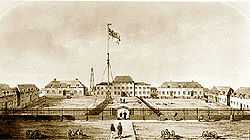
York Factory in 1853 | |
| Location | Manitoba, Canada |
| Area | 102 hectares |
| Founder | Hudson's Bay Company |
| Built | 1788 to 1850 |
| Original use | Fort; military structure; fur trading post |
| Governing body | Parks Canada |
| Website | Parks Canada official website |
| Designated | 1936 |
York Factory was a settlement and factory (trading post) located on the southwestern shore of Hudson Bay in northeastern Manitoba, Canada, at the mouth of the Hayes River, approximately 200 kilometres (120 mi) south-southeast of Churchill. The settlement was headquarters of the Hudson's Bay Company's Northern Department, from 1821 to 1873. It continued to operate as a fur trade post for over 270 years until 1957 when the company closed it down.[1]
The complex was designated a National Historic Site of Canada in 1936.[2] It has been owned by the Canadian government since 1968 and is now operated by Parks Canada. Aside from a summer residence for Parks Canada staff and nearby seasonal hunting camps, there is currently no one living permanently at York Factory. York Factory was built in 1684. The wooden structure at the park site dates from 1831 and is the oldest and largest wooden structure in Canada built on permafrost.
York Factory is currently located on the north bank of the Hayes River about seven miles inland. To the north, across 'Point of Marsh' is the mouth of the Nelson River. Although the Nelson is much larger (it drains Lake Winnipeg), the Hayes is a more practical canoe route. Due to the shallow bottom, seagoing ships anchored at Five Fathom Hole seven miles from the fort and goods were transferred by smaller boats. The Shamattawa Airport and Gillam Airport are close airports.[3]
History

During the 17th through late 19th century, the depot at York Factory and its predecessors were the central base of operations for the Hudson's Bay Company's (HBC)'s control of the fur trade and other business dealings with the First Nations throughout Rupert's Land, the vast territory comprising the entire watershed of Hudson Bay, and which now forms much of Canada.
The first three HBC posts were established on James Bay about 1670. In 1684, Fort Nelson was established at the mouth of the nearby Nelson River. The company built a second fort, York Factory, on the Hayes river, naming it after the Duke of York. The establishment of these forts provoked a response from New France. In the Hudson Bay expedition (1686), the French marched overland from Quebec and captured all the posts on James Bay. During King William's War, France several times sent a naval force to Hudson Bay to capture or destroy the fort. In 1690, Pierre Le Moyne d'Iberville tried but was driven away by a larger English ship. In 1694, d'Iberville returned and captured the factory with a show of force. He renamed it Fort Bourbon. English forces returned the next year and retook the fort from its small French garrison. In 1697, d'Iberville won the Battle of Hudson's Bay, the largest Arctic naval battle in North American history. The French force won in the naval battle with three English warships and again captured the fort. D'Iberville laid siege to the fort in a way that gave the appearance of being a much stronger force. Fort Nelson was held by the French until 1713, when it was returned to the British in the Treaty of Utrecht. In 1713, the headquarters was relocated to the current site on the mouth of the Hayes River.
Between 1788 and 1795, the company constructed an octagonal star fort of stone and brick on the site. The choice of material was poor, however, as the stone and brick could not stand up to heaving permafrost, and in 1831, the stone fort was razed. The three-story center section of the current compound was completed that same year, with the two-story wings finished within the two years that followed.

During its first century, the depot operated by drawing First Nations traders to the post, rather than sending its own traders out into the field. Its position at the mouth of the Nelson allowed access by canoe from the watersheds of the Saskatchewan and Red rivers.
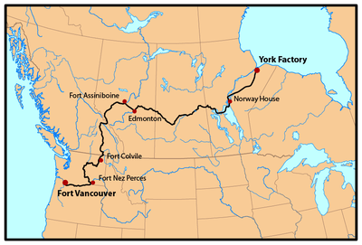
In the late 18th century, the centralized nature of the Hudson's Bay Company's operation from the depot began to become a disadvantage against the more nimble voyageurs of the North West Company. They operated by traveling among the First Nations on the vast water network of lakes and rivers. In response, the company began sending out its own traders from the depot and eventually established inland posts, first along the Saskatchewan River, and then stretching as far as the Oregon Country. Twice annually from 1821 to 1846, brigades known as the York Factory Express traveled overland to Fort Vancouver, headquarters for the HBC's Columbia Department. They brought supplies and trade goods and returned with furs destined for London.
By the mid nineteenth century, York Factory had developed an extensive trading post and settlement with fifty on-site buildings, most currently destroyed, and a permanent workforce. However, the reign of York Factory as one of the most important Hudson Bay Company posts declined within two decades. This is due to the transfer of Northwest Territory to Canada, and changes in the HBC Northwest transportation network’s increased use of the United States railways, steamboats, and Red River carts for Upper Fort Garry’s southern supply line. The depot remained in company hands after the acquisition of Rupert's Land by the Dominion of Canada In 1870. In 1872, York Factory’s role diminished to only outfitting to particular posts located in Manitoba. The post’s fur trade headquarters title was removed a year later and certain responsibilities were transferred to Upper Fort Gary, which is now known as Winnipeg.[4]
The importance of York Factory declined further. In the years 1874-75, the post virtually stopped receiving supplies and goods to be transported elsewhere. The following years, specifically 1878, the post’s British products began being relocated to Norway House.[5] York Factory had a brief upswing when it was designated the headquarters for the new Nelson River District in 1911. However, the Factory lost the title in 1929 to Churchill due to the establishment of the railway line that connected Churchill to Winnipeg. Until closing, York Factory would be known as a regional trading post.[6]
The historic site is currently staffed by Parks Canada from June 1 to mid-September. Archaeological excavations of the 18th-century "octagon" have been conducted since 1991.
In 1957, Hudson's Bay York Factory closed. The residents were relocated to York Landing Cree Nation,[7] about 116 km ENE of Thompson, Manitoba, as well as Split Lake and Shamattawa. In oral stories, Cree elders who once resided at York Factory in the first half of the twentieth century recalled their desires to remain at Kihciwaskahikan or Great House when operations ceased. Kihciwaskahikan and Great House are words for the post used by the Swampy Cree, West Main Cree, Lowland Cree, and/or Home Guard Cree.[8]
See also
References
- ↑ York Factory, The Canadian Encyclopedia
- ↑ York Factory. Canadian Register of Historic Places. Retrieved 17 June 2012.
- ↑ "About Us". Retrieved 8 Jun 2014.
- ↑ Beardy, Flora, and Coutts, Robert, eds, Voices from Hudson Bay: Cree Stories from York Factory, (Montréal: McGill-Queen’s University Press 1996), xxi.
- ↑ Innis, Harold A, The Fur Trade in Canada: An Introduction to Canadian Economic History (Toronto, ON, CAN: University of Toronto Press, 1999), 341.
- ↑ Beardy, Flora, and Coutts, Robert, eds, Voices from Hudson Bay: Cree Stories from York Factory, (Montréal: McGill-Queen’s University Press 1996), xxi.
- ↑ "About Us". York Factory First Nation. Retrieved 16 May 2011.
- ↑ Beardy, Flora, and Coutts, Robert, eds, Voices from Hudson Bay: Cree Stories from York Factory, (Montréal: McGill-Queen’s University Press 1996), xi & xvi
- Peter C. Newman, 'The Empire of the Bay', 1998
External links
| ||||||||||||||||||||||||||||||||||||||||||
| ||||||||||||||||||
Coordinates: 57°00′9.8″N 92°18′17.3″W / 57.002722°N 92.304806°W