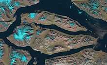
Ymer Island
| Native name: <span class="nickname" ">Ymer Ø | |
|---|---|
 Satellite image | |
 Ymer Island (Greenland) | |
| Geography | |
| Location | East Greenland |
| Coordinates | 73°09′N 24°20′W / 73.150°N 24.333°WCoordinates: 73°09′N 24°20′W / 73.150°N 24.333°W |
| Area | 2,437 km2 (941 sq mi) |
| Highest elevation | 1,900 m (6,200 ft) |
| Highest point | Angelin Bjerg[1] |
| Country | |
| Demographics | |
| Population | 0 |
Ymer (Danish: Ymer Ø) is an island in northeastern Greenland. Its area is 2,437 km². It is mountainous (highest peak is Angelin Bjerg at 1900 m). The island is a part of Northeast Greenland National Park, the largest national park in the world. It is named for the giant Ymir, the forefather of the Jotuns.