Yeading Brook
| Yeading Brook | |
| Stream | |
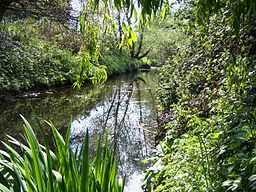 The Yeading Brook flowing through Ruislip Gardens | |
| Country | United Kingdom |
|---|---|
| Tributaries | |
| - left | Roxbourne Brook |
| Source | Headstone Manor |
| - coordinates | 51°35′41″N 0°21′15″W / 51.59472°N 0.35417°W |
| Mouth | |
| - location | River Crane, Greater London |
| - coordinates | 51°30′10.8″N 0°24′24.1″W / 51.503000°N 0.406694°WCoordinates: 51°30′10.8″N 0°24′24.1″W / 51.503000°N 0.406694°W |
| Length | 25.8 km (16 mi) |
Yeading Brook 16 miles (26 km) is a tributary of the River Crane, in West London. It rises in major part from the Headstone Manor moat, and in minor part from a small stream flowing from Pinner Park (which is also the source of the River Pinn). It follows a meandering course through North Harrow, Rayners Lane, Ruislip, South Ruislip (skirting RAF Northolt as it does so where it joins the Roxbourne Brook shortly thereafter), and onwards to Southall, before its confluence with the Crane at Hayes. It is walkable along most of its length, passing through a number of parks, nature reserves and open spaces, including Yeading Brook open space (North Harrow), Roxbourne Park, Ruislip Gardens open space, Ickenham Marsh (where it joins the Hillingdon Trail),[1] Gutteridge Wood and Meadows, Ten Acre Wood, Yeading Brook Meadows (where it joins the Grand Union canal walk), and where shortly thereafter, the brook becomes the river Crane.
References
- ↑ "Hillingdon Trail". London Borough of Hillingdon.
| Wikimedia Commons has media related to Yeading Brook. |