Yatton Keynell
| Yatton Keynell | |
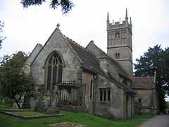 Church of St Margaret |
|
 Yatton Keynell |
|
| Population | 825 (2011) |
|---|---|
| OS grid reference | ST919733 |
| Unitary authority | Wiltshire |
| Ceremonial county | Wiltshire |
| Region | South West |
| Country | England |
| Sovereign state | United Kingdom |
| Post town | CHIPPENHAM |
| Postcode district | SN14 |
| Dialling code | 01249 |
| Police | Wiltshire |
| Fire | Wiltshire |
| Ambulance | South Western |
| EU Parliament | South West England |
| UK Parliament | North Wiltshire, Chippenham |
Coordinates: 51°29′00″N 2°12′00″W / 51.483333°N 2.2°W
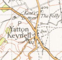
Yatton Keynell (pronounced "kennel") is a village in Wiltshire, England. It is located about five miles (8 km) west of Chippenham, and about five miles (8 km) to the east of the border with South Gloucestershire, on the B4039 road via Castle Combe. Its economy is historically agricultural although it is now more of a residential area for surrounding towns; its population in the first census of 1801 was 353 and by the most recent of 2001, this had risen to 745,[1] and again to 825 in the 2011 census.[2] The village is surrounded by a green belt and is largely a conservation area which explains why unlike other settlements it has not expanded very much over its history.[3]
History
The village was mentioned in the Domesday Book as "Getone". Its name moved through several variations of this and the "Keynell" appears to have been added some time in the 13th century after Henry Caynell, who had a holding in 1242. At about this time, the family gave a tract of land to Stanley Abbey, and the village itself became a grange of the abbey.[3]
A member of the same family, Sir William Keynell, appears to have given the village its current name; in 1250 he built the village church as thanks for his safe return from The Crusades; as a result, it bears the unusual dedication to St Margaret of Antioch.[4] Its tower is 15th century, but the building was mostly restored in 1868 to a design by George Edmund Street.[4]
There is also an Ebenezer Chapel dating back to 1835 to cater for free church worshippers.[5]
The village pub, "The Bell", takes its name from being opposite the church[4] and dates back to the 17th century. In 1764, deeds show its name as "The Old Inn" and consisting of outhouses, stables, a brew house, garden and orchard, remains of which are still visible.[3] The adjacent road, now the B4039 to Castle Combe and beyond, was a toll road and there was a tollbooth close by as recently as 1871.[3]
A farmhouse, called Park Farmhouse, on Grittleton Road is dated to 1778 but was once known as "Small Pox Farm" and was possibly once an isolation house.[3]
The village contains an unusual milestone showing its distance from Hyde Park Corner, London, as 97 miles, and Sodbury as 11 miles.[5]
The nearby hamlet Tiddleywink made national news in 2003 following a campaign by the locals to get it officially recognised on maps.[6]
Facilities
The primary school in the village, By Brook Valley CE Primary School, is used by children from surrounding villages; there is also a separate Under-Fives Group.
The village has a general store and a post office, which was proposed for closure in 2008.[7]
There is a doctors' surgery in Jubilee Field.
The village holds an annual fundraising fete in June of each year and a Christmas Market each December.[5]
Notable people
- John Aubrey, antiquary and writer, known for his descriptions of Avebury and Stonehenge, attended the church school.[3]
- Sir Charles Snell, owned land in Yatton Keynell and sold it to invest in the ship ‘Angel Gabriel’ for the expedition by Raleigh to Guiana in 1595. The family owned ‘The Manor House’ in West Yatton Lane from the late 17th century.[3]
Elected representatives
The village is represented in parliament by James Gray and in Wiltshire Council by Jane Scott, both Conservatives.
Gallery
-
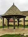
A new shelter in the centre
-
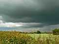
Field, sunshine and cloud near Yatton Keynell
External links
References
- ↑ "Yatton Keynell Census Information". Retrieved 2010-11-08.
- ↑ "Parish population 2011.Retrieved 11 March 2015".
- ↑ 3.0 3.1 3.2 3.3 3.4 3.5 3.6 "Yatton Keynell". Wiltshire Council. Retrieved 2010-11-08.
- ↑ 4.0 4.1 4.2 "Yatton Keynell, Wiltshire". Retrieved 2009-01-09.
- ↑ 5.0 5.1 5.2 "Welcome to Yatton Keynell, Village Magazine". Retrieved 2009-01-09.
- ↑ Tiddleywink on the map - BBC News article dated Wednesday, February 19, 2003
- ↑ "Post Office closures in Wiltshire". Retrieved 2009-01-05.