Yateley
| Yateley | |
 Yateley |
|
| Population | 20,214 (2009) |
|---|---|
| OS grid reference | SU8160 |
| Civil parish | Yateley |
| District | Hart |
| Shire county | Hampshire |
| Region | South East |
| Country | England |
| Sovereign state | United Kingdom |
| Post town | YATELEY |
| Postcode district | GU46, GU17 (part) |
| Dialling code | 01252 01276 (part) |
| Police | Hampshire |
| Fire | Hampshire |
| Ambulance | South East Coast |
| EU Parliament | South East England |
| UK Parliament | North East Hampshire |
Coordinates: 51°20′00″N 0°50′19″W / 51.33333°N 0.83871°W
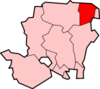
Yateley is a suburban town and civil parish in the English county of Hampshire. It lies in the north-eastern corner of Hart District Council. It includes the settlements of Frogmore and Darby Green. It had a population of 21,011[1] according to the 2001 census. The four wards that comprise Yateley and their 2001 populations are Yateley East (5,168), Yateley North (5,078), Yateley West (5,149), and Frogmore & Darby Green (5,616). The 2009 projection was 20,214, according to the Hart District Council website.[2] Yateley Town Council is one of the few local councils to have been recognised under the national 'Quality Council' award scheme.[3]
In 2011 Hart district was named the UK's most desirable place to live, and Yateley was mentioned on a BBC news article as one of the towns within the district.[4] In 2014, it was rated one of the most attractive postcode areas to live in England. [5]
Location
Yateley’s northern border is the River Blackwater, of which is partially swollen to form the Yateley Lakes, dividing Yateley from the parish of Sandhurst and its county Berkshire. The southern border is the A30 national route, lined by the Yateley Commons Country Park and Blackbushe Airport. It lies some 35 miles (56 km) west-south-west of London and 15 miles (24 km) south of Reading.
Yateley’s flora and fauna can be characterised the Yateley Commons and nearby Castle Bottom nature reserve, linked by a trail that defines the westerly border of Yateley accessed via its residential area. It’s a makeup of woodlands, open heathlands, and various bodies of water.
Yateley is topologically inclined northerly into Blackwater valley, and thus its sewage and storm water flow.
Amenities

Yateley is a residential area with local businesses and light service industries. The B3272 Reading Road acts as the town's main business link, with numerous shops and other businesses located along this road. The area around St Peter's church, the Dog & Partridge public house and the village green is still referred to as 'the village'. Yateley Green is a larger open area slightly to the west where there are tennis courts, a playground, Town Council offices and 'The Tythings' community hall and is the location for the annual May Fayre, one of the largest events of its kind in southern England. Yateley Cricket and Hockey Club is situated adjacent to the Blackwater Valley golf course, off Chandlers Lane. There are several traditional public houses, besides the Dog & Partridge: the White Lion, the Royal Oak, the Cricketers, the Anchor Inn (Vigo Lane) and The Highwayman (formerly Poets' Corner, formerly the Monteagle Arms, formerly The Lanes).
There is a Waitrose which is the largest supermarket within the town as well as a Co-Op and several smaller stores.
Transport
Yateley is mainly a commuter town with direct road links to London, Reading, Aldershot and Guildford. Local public transport provides no direct link to London, Basingstoke or Reading..
There is only one bus route - the round-route 3 via Camberley and Aldershot (Stagecoach in Hants and Surrey) and the 72, 79 and 82 (Fleet Buzz).[6] There is no railway station.
The town also contains within its boundaries the Blackbushe Airport complex, which caters for leisure flights, flying lessons and small business flight operations. The complex also contains a thriving car auction, a go-kart track, parts of an abandoned World War II airfield (those parts of RAF Hartford Bridge which are not now part of Blackbushe Airport) and is the venue for the popular Blackbushe Sunday Market.
Sports
Yateley FC is a club that was established in 1927 for men's football. In 1967 Yateley Juniors FC was formed for Youth players. In 2008 both clubs merged to form a single club called Yateley FC. They have 13 youth teams from U6s to U18s, and three men's teams. The annual event "Gig On The Green" is held at the end of June every year on Yateley Green to raise funds for sports facilities in the area, including Yateley FC.
Darby Green and Potley FC - Darby Green FC and Potley and Frogmore FC merged with each other in 2010 due to lack of players. Jed Wallace, a professional Football player, played for Darby Green and Potley FC.
History
The name Yateley derives from the Middle English 'Yate' meaning 'Gate' (into Windsor Forest) and 'Lea' which was a 'forest clearing'. . Although in historic records, variations of the spelling include Hyatele, Yateleghe, Yatche, Yatelighe, Yeatley, Yeateley and Yatelegh.[7] The town's logo is a three-barred gate with the keys of Saint Peter (the church dedication) and the Tudor rose of Hampshire. The parish was originally much larger, covering both Blackwater and Hawley.
Yateley Hall in the town dates from the 13th century, but the town itself was mentioned in the Domesday Book of 1086 as Effelle.[8] In the early 17th century, Monteagle Farm was one of the minor properties of the 'discoverer' of the Gunpowder Plot, Lord Monteagle. A tradition has grown up that some of the first plans for the plot were put together there, but this is highly unlikely. However, roads of the residential area around Monteagle Lane have been named after some of the conspirators in memory of the connection.
Through the next few centuries, Yateley developed into a coaching-hub between London and Reading. Local legend has it that the curate of Yateley, named Parson Darby, was a highwayman who used the Reading Road as his main stamping ground. Darby Green, where he was hanged, is named after him. The "beast" of Yateley Morris Men is a wooden horse wearing a highwayman's disguise, in memory of Parson Darby.
The Yateley Society is a registered charity one aim of which is to research and provide information to the public on the history, natural history, architecture and geography of Yateley.
Education
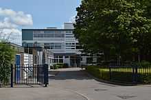
Yateley School in School Lane and Frogmore Community College on the Reading Road are both comprehensive secondary schools. They also both have leisure centres, and Yateley School has a Sixth Form.
Following the closure and amalgamation of St Peter's Church of England Junior School and Yateley Infant School a new Primary School opened in September 2010. Named Cranford Park CE Primary School.[9] and catering for around 200 pupils, the new school moved into state of the art facilities on Cranford Park Drive in September 2011.
Other schools in Yateley are Westfields Infant and Junior Schools in School Lane with around a total of 630 students, Potley Hill Primary School, located next to Frogmore Community College, which caters for 200 students and Newlands Primary School, in Dungells Lane, which caters for around 200.[10]
Yateley Manor School is an independent school catering for around 500 pupils aged 3 to 13.[11] The majority of pupils from this school go on to Lord Wandsworth College, Wellington College, Berkshire and Farnborough Hill. The school is active in sport and is a very active supporter of chess and strongly promotes the benefits of chess as part of the curriculum. It has just (2008) become the new sponsor of the National Schools Chess Championships.[12]
The nearest university is the University of Reading, with its Whiteknights campus lying only 14 miles to the northeast of Yateley.
In the media
- Singer Alexa Goddard received secondary education at Yateley School, during her emergence of becoming a singer.
- Flora Thompson, author of the trilogy of novels 'Lark Rise to Candleford' is recorded in the 1901 Census as living and working in the Yateley Post Office. These books have since been adapted for television by the BBC.
- Sonny Black a leading UK acoustic guitarist also lives in Yateley.
- Contemporary artist James Robert Ford grew up in Yateley and attended Yateley School. A number of his projects, including House Gymnastics, General Carbuncle,[13] and 33 Things to do before you're 10,[14] have taken place in Yateley.
- Chris Benham, a Hampshire cricketer, grew up in Yateley and attended Yateley School.
- Author Danny King grew up in Yateley and attended Yateley School.
- Sean Devereux, a charity worker in Somalia came from Yateley. He was assassinated and Sean Devereux Park is named after him.
- The body of missing school girl Amanda Dowler was found in woodland close by on 18 September 2002
- David Copeland, known as the "London Nailbomber" after a 13-day bombing campaign in April 1999 aimed at London's black, Asian, and gay communities, grew up in Yateley, though resided in nearby Cove in Farnborough at the time of the attack.
References
- ↑ National Statistics
- ↑ Yateley Town Council
- ↑ Quality Council Award
- ↑ "Hart in Hampshire named as UK's most desirable place". BBC News. 24 December 2011.
- ↑ "UK's 'most desirable' postcodes revealed". BBC News.
- ↑ "Camberley, Farnborough and Yateley bus timetables". Retrieved 12 May 2012.
- ↑ 'Cove - Old and New' by Maye Watson and L. F. CALLINGHAM (circa. 1925) Page 45
- ↑ A HISTORY OF HAMPSHIRE AND THE ISLE OF WIGHT
- ↑ Cranford Park C of E Primary School
- ↑ 'Cove - Old and New' by Maye Watson and L. F. CALLINGHAM (circa. 1925) Page 35
- ↑ Yateley Manor School
- ↑ Chess Championships
- ↑ General Carbuncle,
- ↑ 33 things to do before you're 10
External links
- "National Statistics". 2001 Census — Aldershot Urban Area. Retrieved April 22, 2005.
- h2g2 Yateley Edited Guide Entry
- Yateley Town Council
- St Peter's Church (Church of England)
- St Swithun's Church (Catholic)
- Yateley Baptist Church
| ||||||||||||||||||||||||||