Yarraman, Queensland
| Yarraman Queensland | |
|---|---|
|
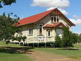
Our Lady of Dolours Roman Catholic church in Yarraman | |
 Yarraman | |
| Coordinates | 26°50′21″S 151°58′39″E / 26.83917°S 151.97750°ECoordinates: 26°50′21″S 151°58′39″E / 26.83917°S 151.97750°E |
| Population | 945 (2006 census)[1] |
| Postcode(s) | 4614 |
| Elevation | 407 m (1,335 ft) |
| Location |
|
| LGA(s) | Toowoomba Region |
| County | Cavendish |
| Parish | Cooyar |
| State electorate(s) | Nanango |
| Federal Division(s) | Maranoa |
Yarraman is a town in Queensland, Australia. The town is located 181 kilometres (112 mi) northwest of the state capital, Brisbane on the junction of the New England and D'Aguilar highways.
History
The creek at Yarraman was used in the 1870s as a place for local graziers and stockmen to meet and trade cattle. The township was established in the late 1870s.[2] The name of Yarraman is derived from the aboriginal word meaning horse.[3] Although the origin of the word Yarraman is unknown, it is thought to be derived from the word "yira" which means large teeth.[4]
A school was opened in 1901.[2]
As there were many large Hoop Pine forests in the area, a timber mill was established in 1910.[2]
The town was connected to Brisbane and Ipswich by railway in 1913.[2] The railway line was closed in 1988.[5]
Census data
Based on data gathered through the census, Yarraman's population has grown as shown below.
| Year | Number of people | Census data link |
|---|---|---|
| 2001 | 897 | [6] |
| 2006 | 945 | [1] |
| 2011 | 1230 | [7] |
Today
Yarraman is set in a fertile valley and produces timber, grain and beef and dairy goods, which it exports to larger cities. It has a community radio station Wild Horse FM 99.7. It is served by three churches: St Philip's Anglican Church, Our Lady of Dolours Catholic Church, and Calvary Lutheran church.
Yarraman is surrounded by the various components of the fragmentary Bunya Mountains and Yarraman Important Bird Area which contains the largest remaining population of the vulnerable Black-breasted Button-quail.[8]
Amenities
The Yarraman Library and Post Office are located on the corner of Toomey and Douglas Streets.[9][10]
The Yarraman Memorial Pool is located in Margaret Street, on the New England Highway.[11]
References
- ↑ 1.0 1.1 Australian Bureau of Statistics (25 October 2007). "Yarraman (L) (Urban Centre/Locality)". 2006 Census QuickStats. Retrieved 2007-12-30.
- ↑ 2.0 2.1 2.2 2.3 South Burnett Net: Yarraman, accessed 17 Jan 2010
- ↑ "Yarraman Queensland Places". Retrieved 7 November 2014.
- ↑ "Queensland places names search". Retrieved 7 November 2014.
- ↑ Queensland Places: Yarraman, accessed 17 Jan 2010
- ↑ Australian Bureau of Statistics (9 March 2006). "Yarraman (L) (Urban Centre/Locality)". 2001 Census QuickStats. Retrieved 2010-01-17.
- ↑ Australian Bureau of Statistics (31 October 2012). "Yarraman, QLD". 2011 Census QuickStats. Retrieved 2014-10-24.
- ↑ "IBA: Bunya Mountains & Yarraman". Birdata. Birds Australia. Retrieved 2011-06-08.
- ↑ "Yarraman Library". Retrieved 25 October 2014.
- ↑ "Post Office". Retrieved 25 October 2014.
- ↑ "Yarraman Pool". Retrieved 25 October 2014.
External links
| Wikimedia Commons has media related to Yarraman, Queensland. |
- Community website
- Queensland Places: Yarraman
- South Burnett Net: Yarraman
- Yarraman cemetery headstone photos
| ||||||||||||||||||
| ||||||||||||||||||||||