Yanarahu (Asunción-Carhuaz-Yungay)
| Yanarahu | |
|---|---|
 | |
| Elevation | 5,954 m (19,534 ft)[1] |
| Location | |
 Yanarahu Peru | |
| Location | Peru, Ancash Region |
| Range | Andes, Cordillera Blanca |
| Coordinates | 9°06′22″S 77°29′25″W / 9.10611°S 77.49028°WCoordinates: 9°06′22″S 77°29′25″W / 9.10611°S 77.49028°W |
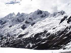
Yanarahu[2][3](Quechua yana black,[4] rahu snow, ice, mountain with snow,[5] "black snow peak", hispanicized spellings Yanarrajo, Yanarraju), Ruriqucha[6] (Quechua ruri inside, Ancash Quechua ruri interior; inside; deep; valley or little river,[7][8] Quechua qucha lake, "interior lake", "deep lake" or "valley lake", hispanicized Ruricocha), Contrahierba,[9]Contrahierbas[10] or Contrayerba (Spanish) is a mountain in the Cordillera Blanca in the Andes of Peru, about 5,954 metres (19,534 ft) high. It is situated in the Ancash Region in the provinces Asunción, Carhuaz and Yungay. Yanarahu lies in the Huascarán National Park, northeast of the Wallqan.
See also
References
- ↑ bielefeldt.de The world's highest mountains, Nevado Contrahierbas, 5954, height corrected according to "Die Anden" (H.Kiendler)
- ↑ minjus.gob.pe LEY Nº 23764
- ↑ escale.minedu.gob.pe - UGEL map of the Yungay Province (Ancash Region) showing "Nevado Yanarraju / Yanarrajo"
- ↑ Teofilo Laime Acopa, Diccionario Bilingüe, Iskay simipi yuyay k'ancha, Quechua – Castellano, Castellano – Quechua: yana - adj. Negro, -gra. De color muy oscuro. || Oscuro, -ra. Que carece de luz o claridad.
- ↑ babylon.com
- ↑ John Biggar, The Andes: A Guide for Climbers, p. 76
- ↑ Vocabulario comparativo quechua ecuatoriano - quechua ancashino -- castellano - English (pdf)
- ↑ Rubén Alejandro Mejía Méndez, Toponimia del Distrito de Yaután, Universidad Nacional Mayor de San Marcos, Lima, 2007
- ↑ muniyanama.gob.pe
- ↑ www.andix.com Map of a part of the Cordillera Blanca
External links
| Wikimedia Commons has media related to Cordillera Blanca. |