Wyna River
| Wyna | |
| Wyne | |
| River | |
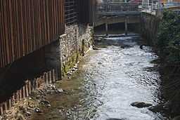 Wyna River in Menziken | |
| Country | Switzerland |
|---|---|
| Region | Wynetal |
| Part of | Suhre watershed |
| Tributaries | |
| - left | Lochbach, Moosbach, Rickenbach, Dorfbach |
| - right | Schwarzenbach |
| Source confluence | Lochbach |
| - location | Underdorf, Lucerne, Switzerland |
| - elevation | 660 m (2,165 ft) |
| - coordinates | 47°11′06″N 8°12′26″E / 47.18494°N 8.20721°E |
| Mouth | Suhre |
| - location | Suhr, Aargau, Switzerland |
| - elevation | 385 m (1,263 ft) |
| - coordinates | 47°22′50″N 8°05′04″E / 47.38053°N 8.08433°ECoordinates: 47°22′50″N 8°05′04″E / 47.38053°N 8.08433°E |
| Length | 32 km (20 mi) |
| Discharge | |
| - average | 0.9 m3/s (32 cu ft/s) |
The Wyna River is a river located mostly in Canton Aargau, but also in Canton Lucerne, Switzerland. It is a tributary of the Suhre River. The Wynental is the Wyna River valley.
River
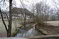
The Wyna River is 32 km long. It begins north of Neudorf, just west of the small hamlet of Underdorf. At this point, the Lochbach (or Gap Creek, which starts in the Chegelwald, west of Neudorf) is joined by various intermittent streams arising all around Neudorf. The Wyna runs north between Beromünster and Menziken before connecting with the Suhre River just north of Suhr. Tributaries that feed the Wyna include the Moosbach (left, north of Beromünster), Schwarzenbach (right, at south Menziken), Rickenbach (left, at south Menziken), and Dorfbach (left, at Zetzwil). The Wyna River is also referred to as the Wina or Wyne River.[1]
Valley
The valley is fairly narrow, with an average width of about 500 meters. Steep hills rise on both sides, carved by tributary valleys. Municipalities found in the Wynental from beginning to end of the Wyna are: Neudorf, Beromünster, Burg/Menziken, Pfeffikon, Reinach, Leimbach, Zetzwil, Gontenschwil, Oberkulm/Unterkulm, Teufenthal, Gränichen, and Suhr. The Wynental is also referred to as the Wynetal or Wynatal. The general region is also referred to as Stumpenland due to the cigar industry that once centered in Menziken.
Glacial genesis
The upper portions of the valley was carved by the Reuss glacier. Large moraine deposits remain at Zetzwil and Gontenschwil. The surrounding hills are largely molasse.
Transportation
Connecting road 23 runs along the Wyna for the majority of the valley's length from Beromünster to Suhr. This road is referred to variously as Aargauerstrasse, Hauptstrasse, Aarauerstrasse, Wynentalstrasse, and numerous names north of Teufenthal and is a popular cycling route.[2] The WSB (Wynental und Suhrental Bahn), a narrow gauge railroad, serves the Wynental. The Wynental branch of the WSB runs from Aarau to Menziken.
Points & Events of Interest
- Naturschutzgebiet Vogelmoos (Bird Moss Nature Preserve), one source of the Wyna
- Auffahrtsumritt in Beromünster (Ascension Day procession)
- Stiftskirche (collegiate church) St. Michael, Beromünster – dating to 1034
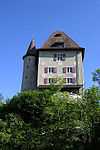
- Castle (Schloss) Liebegg, north of Teufenthal
- Castle (Schloss) Trostburg, east side of Teufenthal (private estate)
- "Streckenplan Wyna-Trail" [Route map Wyna Trail] (in German). Gemeinde Beromünster. Hiking trails along and near the Wyna, connecting Beromünster, Menziken, and Gunzwil.
External links
- Historische Vereinigung Wynental (Wynental Historical Society)
- Google Earth map
- "Wynematte" (in German). Pro Natura Aargau. Removal of dams and renaturalization of Wyna at Menziken
- Tschannen, Martin (November 2011). "Hochwasserschutz und Renaturierung der Wyna" [Flood protection and restoration of Wyna] (PDF). Umwelt Aargau (in German) (Aargau: Abteilung Landschaft und Gewässer) (34): 53–55. Retrieved 21 June 2013. Good discussion of renaturalization efforts
Photographs
- "Wynatal & surrounding".
|first1=missing|last1=in Authors list (help)
References
- ↑ "Revitalisierung der Wyna bei Menziken" [Revitalization of Wyna at Menziken] (PDF), Riverwatch (Factsheet Revitalisierungsprojekte 1) (in German) (WWF Schweiz), December 2006, retrieved 21 June 2013,
The Wyna is a 31-kilometer mountain stream larger (mean Outflow in Reinach: 0.9 m3/s). It flows through the Cantons of Lucerne and Aargau. Larger towns in Wynental are Menziken, Reinach and Graenichen. The river rises north of Neudorf at an altitude of The Wyna is a 31-kilometer mountain stream larger (mean Outflow in Reinach: 0.9 m3/s). It flows through the Cantons of Lucerne and Aargau. Larger towns in Wynental are Menziken, Reinach and Graenichen. The river rises north of Neudorf at an altitude of 660 meters above sea: There unite several short Headwaters. North of Graenichen leads to the Wyna a height of 385 meters in the Suhre, this in turn leads three kilometers further north in the river Aare.
- ↑ "Wynental-Route, Luzern–Aarau". Cycling in Switzerland. Bern: SwitzerlandMobility Foundation. Retrieved 23 Mar 2012.
In Römerswil, 90 farmers still work the lush green land on the flat rise of the Erlosen, the source of the small streams that feed the Wyna. After crossing the rise (794 m) the 215 metre-high transmitter of Radio Beromünster appears to the west. This fell silent in 2008 after 77 years of medium-wave broadcasts. Because of the name of the transmitter, in 1934, Münster was renamed Beromünster, where the ornately decorated collegiate church encircled by canons’ houses is enthroned above the historic market town. The railway ran to «Möischter» until 1992: today the tracks run in leisurely fashion down to the agglomeration of Menziken/Reinach, where the first flexible aluminium foil was pressed in 1905 and where aluminium is still processed. In the region, also known as «Stumpenland» (cigar country), only the major cigar names of Burger and Villiger have survived: the famous Rössli cigars have been smoked since 1933. In the Menziken Tobacco Museum, cigar boxes with the aroma of tobacco recall the heyday of cigars. Often unspoilt and bordered by bushes, the Wyna winds through the wide glaciated valley, under the eye of thatched granaries dating from 1540 at Oberkulm and the tiny castles of Trostburg and Liebegg above Teufenthal. On the way to Suhr, the plastic industry and large JOWA bakery supply a rich contrast of aromas. The route then runs alongside the Stadtbach, through suburbs to Aarau.