Wustermark
| Wustermark | ||
|---|---|---|
| ||
 Wustermark | ||
Location of Wustermark within Havelland district  | ||
| Coordinates: 52°32′59″N 12°56′59″E / 52.54972°N 12.94972°ECoordinates: 52°32′59″N 12°56′59″E / 52.54972°N 12.94972°E | ||
| Country | Germany | |
| State | Brandenburg | |
| District | Havelland | |
| Government | ||
| • Mayor | Bernd Drees (SPD) | |
| Area | ||
| • Total | 52.63 km2 (20.32 sq mi) | |
| Population (2012-12-31)[1] | ||
| • Total | 8,042 | |
| • Density | 150/km2 (400/sq mi) | |
| Time zone | CET/CEST (UTC+1/+2) | |
| Postal codes | 14641 | |
| Dialling codes | 033234 | |
| Vehicle registration | HVL | |
| Website | www.wustermark.de | |

Wustermark is a municipality of the Havelland district, in Brandenburg, Germany.
History
It was established in 2002 through a merger of the five villages Buchow-Karpzow, Elstal, Hoppenrade, Priort and Wustermark.

Interior of the dining hall for the 1936 Summer Olympics, unrestored as of 2012.
Near Elstal are the remains of the Olympic Village of the 1936 Summer Olympics in Berlin.
Demography
-
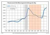
Development of Population since 1875 within the Current Boundaries (Blue Line: Population; Dotted Line: Comparison to Population Development of Brandenburg state; Grey Background: Time of Nazi rule; Red Background: Time of Communist rule)
-
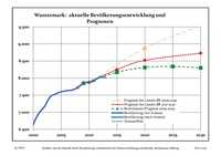
Recent Population Development (Blue Line) and Forecasts
|
|
|
|
Detailed data sources are to be found in the Wikimedia Commons.[3]
See also
References
- ↑ "Bevölkerung im Land Brandenburg nach amtsfreien Gemeinden, Ämtern und Gemeinden 31. Dezember 2012 (XLS-Datei; 83 KB) (Einwohnerzahlen auf Grundlage des Zensus 2011)". Amt für Statistik Berlin-Brandenburg (in German). 31 December 2012.
- ↑ Boundaries as of 2013
- ↑ Population Projection Brandenburg at Wikimedia Commons
External links
![]() Media related to Wustermark at Wikimedia Commons
Media related to Wustermark at Wikimedia Commons
| ||||||||