Wrightsville, New Jersey
| Wrightsville, New Jersey | |
|---|---|
| Unincorporated community | |
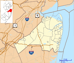
 Wrightsville, New Jersey Location of Wrightsville in Monmouth County Inset: Location of county within the state of New Jersey | |
 Wrightsville, New Jersey Location within the state of New Jersey | |
| Coordinates: 40°10′53″N 74°30′34″W / 40.18139°N 74.50944°WCoordinates: 40°10′53″N 74°30′34″W / 40.18139°N 74.50944°W | |
| Country | United States |
| State | New Jersey |
| County | Monmouth |
| Township | Upper Freehold |
| Elevation[1] | 154 ft (47 m) |
| Time zone | Eastern (EST) (UTC-5) |
| • Summer (DST) | EDT (UTC-4) |
| GNIS feature ID | 881965[1] |
Wrightsville is an unincorporated community located within Upper Freehold Township in Monmouth County, New Jersey, United States.[2]
References
- ↑ 1.0 1.1 "Wrightsville". Geographic Names Information System. United States Geological Survey.
- ↑ Locality Search, State of New Jersey. Accessed March 13, 2015.
