Wright's Bridge
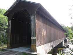
Wright's Bridge is a historic covered bridge in Newport, New Hampshire. Originally built in 1906 to carry the Boston and Maine Railroad across the Sugar River, it now carries the multi-use Sugar River Trail, which was built on the abandoned right-of-way. The bridge is located about 1,200 feet (370 m) west of the trail's intersection with Chandler Mill Road in western Newport. The bridge is a single-span Town double-lattice truss structure which has been reinforced by laminated arches. The bridge spans 122 feet (37 m), with 6 feet (1.8 m) of overhang at each end, and rests on granite abutments. It is named for S. K. Wright, who sold this portion of the railroad right-of-way in 1871.[2]
The bridge was listed on the National Register of Historic Places in 1975.[1]
See also
References
External links
|
|---|
| | Topics | | |
|---|
| | Lists by county | |
|---|
| | Other lists | |
|---|
|
-
 Category:National Register of Historic Places in New Hampshire Category:National Register of Historic Places in New Hampshire
-
 Portal:National Register of Historic Places Portal:National Register of Historic Places
|
|