Woronora River
| Woronora | |
| River[1] | |
 Woronora River | |
| Name origin: Aboriginal (Dharug): "black rocks"[1] | |
| Country | Australia |
|---|---|
| State | New South Wales |
| Region | Greater Metropolitan Sydney |
| Local government area | Sutherland Shire |
| Part of | Georges River catchment |
| Tributaries | |
| - left | Still Creek (New South Wales) |
| - right | Heathcote Creek, Forbes Creek (New South Wales) |
| Primary source | Illawarra escarpment |
| Secondary source | Waratah Rivulet |
| - location | near Darkes Forest |
| - elevation | 353 m (1,158 ft) |
| - coordinates | 34°23′17″S 150°54′18″E / 34.38806°S 150.90500°E |
| Mouth | confluence with the Georges River |
| - location | between Como and Illawong |
| - elevation | 0 m (0 ft) |
| - coordinates | 33°59′40″S 151°4′3″E / 33.99444°S 151.06750°ECoordinates: 33°59′40″S 151°4′3″E / 33.99444°S 151.06750°E |
| Length | 36 km (22 mi) |
| Basin | 174 km2 (67 sq mi) |
| Dam | Woronora (1941) |
| National parks | Heathcote; Royal |
 NASA satellite view of Greater Metropolitan Sydney, with the location of the mouth of the Woronora River, as marked
| |
| [2] | |
The Woronora River is a perennial river of the Sydney Basin, located in the Sutherland Shire local government area of Greater Metropolitan Sydney, approximately 22 kilometres (14 mi) south of the Sydney central business district, in New South Wales, Australia.
Location and features
The Woronora River rises on the northwestern slopes of the Illawarra escarpment and has its origin from Waratah Rivulet, near Darkes Forest, and flows generally north for approximately 36 kilometres (22 mi), joined by three minor tributaries, before reaching its confluence with the Georges River, between Como and Illawong. The total catchment area of the river is approximately 174 square kilometres (67 sq mi) and the area is generally administered by the Sydney Catchment Authority in its upper reaches and the Sutherland Shire Council in its lower reaches.[3] Much of the course of the river is through the Dharawal State Conservation Area, Heathcote National Park and the Royal National Park as it descends 354 metres (1,161 ft) from source to mouth.[2]
The river is impounded by the Woronora Dam, opened in 1941. The 71,790-megalitre (2,535×106 cu ft) impoundment is Lake Woronora, formed to augment water supply for southern Sydney and the northern Illawarra region.[2]
The Woronora River is traversed by high level and low level road bridges and a footbridge in the suburb of Woronora. A road bridge on Heathcote Road, linking Heathcote and Holsworthy also provides a crossing over the river. At the area known as "The Needles", near Woronora Road in Engadine, a footbridge links the suburb to Barden Ridge.
Etymology
In the Australian Aboriginal Dharug language the river draws its name, meaning "black rocks".[1]
Gallery
-

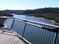
Woronora Bridge, view towards Sutherland
-

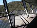
The Woronora Bridge walkway.
-
-
See also
References
- ↑ 1.0 1.1 1.2 "Woronora River". Geographical Names Register (GNR) of NSW. Geographical Names Board of New South Wales. Retrieved 5 January 2013.
- ↑ 2.0 2.1 2.2 "Map of Woronora River, NSW". Bonzle Digital Atlas of Australia. Retrieved 10 March 2014.
- ↑ Acer Wargon Chapman (September 1995). "Woronora River Floodplain Management Study" (PDF). Sutherland Shire Council. Retrieved 5 January 2013.
External links
- "Georges River catchment" (map). Office of Environment and Heritage. Government of New South Wales.
- Woronora River Stormwater Management Plan, commissioned by Sutherland Shire Council, September 2000.
- Woronora River Floodplain Management Study, commissioned by Sutherland Shire Council, September 1995.
- The Woronora River at "The Great Kai'mia Way"
- Map of Woronora River, NSW at Bonzle Digital Atlas of Australia.
| ||||||||||||||||||||||||||||||||||
| ||||||||||||||||||||||||||||||||||||