Woolooga
| Woolooga Queensland | |
|---|---|
|
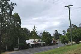
The main street of Woolooga, showing the general store, with the pub and community hall around the bend. | |
 Woolooga | |
| Coordinates | 26°03′0″S 152°24′0″E / 26.05000°S 152.40000°ECoordinates: 26°03′0″S 152°24′0″E / 26.05000°S 152.40000°E |
| Population | 319 (2006 census)[1] |
| Established | 1910 |
| Postcode(s) | 4570 |
| Location | |
| LGA(s) | Gympie Region |
| State electorate(s) | Callide |
| Federal Division(s) | Wide Bay |
Woolooga is a town in the Wide Bay region of Queensland, Australia. The town is located in the Gympie Region local government area, 221 kilometres (137 mi) north of the state capital, Brisbane. At the 2006 census, Woolooga and the surrounding rural area had a population of 319.[1]
History
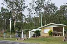
Woolooga Memorial Park, 2010
The Woolooga Memorial Park commemorates those who served in war. It is located in Thomas Street.[2]
Woolooga was affected by the 2010–2011 Queensland floods. A 2-metre (6.6 ft) wall of water rushed through the town, inundating the public hall and the pub.[3] The general store was also severely damaged by the flood.[4]
Heritage listings
Woolooga has a number of heritage-listed sites, including:
- Theebine - Kilkivan Line: Woolooga Rail Bridge[5]
References
- ↑ 1.0 1.1 Australian Bureau of Statistics (25 October 2007). "Woolooga (Kilkivan Shire) (State Suburb)". 2006 Census QuickStats. Retrieved 19 January 2011.
- ↑ "Woolooga Memorial Park". Monument Australia. Retrieved 6 April 2014.
- ↑ "Western areas hit with record rain". Gympie Times. 9 January 2011. Retrieved 19 January 2011.
- ↑ Harch, Christine (19 January 2011). "Spirit not dampened by floods". Gympie Times. Retrieved 19 January 2011.
- ↑ "Woolooga Rail Bridge (entry 15420)". Queensland Heritage Register. Queensland Heritage Council. Retrieved 2013-07-08.
External links
![]() Media related to Woolooga, Queensland at Wikimedia Commons
Media related to Woolooga, Queensland at Wikimedia Commons