Woolloongabba
| Woolloongabba Brisbane, Queensland | |||||||||||||
|---|---|---|---|---|---|---|---|---|---|---|---|---|---|
|
Former post office on Stanley Street in Woolloongabba. | |||||||||||||
| Coordinates | 27°29′28″S 153°02′18″E / 27.49111°S 153.03833°ECoordinates: 27°29′28″S 153°02′18″E / 27.49111°S 153.03833°E[1] | ||||||||||||
| Population | 4,789 (2011 census)[2] | ||||||||||||
| • Density | 2,000/km2 (5,170/sq mi) | ||||||||||||
| Postcode(s) | 4102[3] | ||||||||||||
| Area | 2.4 km2 (0.9 sq mi) | ||||||||||||
| Location | 2 km (1 mi) SE of CBD[4] | ||||||||||||
| LGA(s) |
City of Brisbane (The Gabba Ward) | ||||||||||||
| State electorate(s) | South Brisbane | ||||||||||||
| Federal Division(s) | Griffith | ||||||||||||
| |||||||||||||
%2C_1905.JPG)
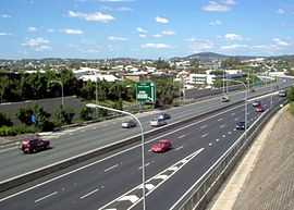
Woolloongabba is a suburb of Brisbane, Australia. It is located 2 kilometres (1.2 mi) south-east of the CBD,[4] and contains the Brisbane Cricket Ground ('the Gabba') and the Princess Alexandra Hospital. It is crossed by several major roads including the Pacific Motorway. The suburb was once home to a large tram depot.
Toponymy
Experts are divided regarding the Aboriginal meaning of the name, preferring either 'whirling waters' (woolloon and capemm) or 'fight talk place' (woolloon and gabba).[5]
Because the area was low-lying and swampy, it was known as the One Mile Swamp. Although this name appears to be unofficial, it was in common use until the early 1890s.[6]
History


The suburb has a significant link to the history of transport in Brisbane. Between 1884 and 1969 the main railway locomotive depot for lines south of the Brisbane River was beside Stanley St. It was reached via a line that ran beside Stanley St, then crossing it, Logan Road and Ipswich Road to the main line at Dutton Park. By the 1960s services from the depot were causing significant delays to traffic as they crossed these three major roads.
The suburb was served by horse-drawn trams from 1885 to 1897, which were replaced by electric trams, which in turn ceased operation on 13 April 1969. All but one of Brisbane's trolleybus routes traversed the suburb, from 1953 to 1969. The Woolloongabba Fiveways (the intersection of Stanley Street, Main Street, Logan Road and Ipswich Road) was a complex junction with tram and railway lines, and tram and trolleybus overhead. Trams were controlled by a signalman, who operated the points (or switches) from a signal cabin near the eastern side of the junction. Trains were escorted across the junction by a flagman. Curiously, Queensland Railways always referred to the branch line as the Wooloongabba Branch, spelt with only one 'l'.[7]
From 1927 until 1969 the largest of the Brisbane City Council's tram depots was on Ipswich Road, opposite the Princess Alexandra Hospital. It was also used by the council's buses.
In early 1942 the first Coca-Cola bottling plant in Australia was built in Woolloongabba at 36-39 Balaclava Street.[8] It was originally designed to supply the demands of the newly arrived US military personnel, but later expanded production to the local Australian market.
Attractions
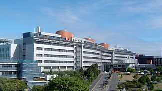
The suburb is home to the Brisbane Cricket Ground known as "The Gabba", and the Princess Alexandra Hospital. Woolloongabba has many apartment buildings due to river views, and the suburb's proximity to the Brisbane central business district and South Bank Parklands. The Norman Hotel is a local landmark that has served customers since 1890.[9]
Heritage listings
Woolloongabba has a number of heritage-listed sites, including:
- Princess Theatre (8 Annerley Road)[10]
- former Dispenser's House of Diamantina Hospital (Cornwall Street) [11]
- Holy Trinity Anglican Church (68 Hawthorne Street)[12]
- Norman Hotel (102 Ipswich Road)[13]
- former Taylor-Heaslop Building (10-14 Logan Road)[14]
- Broadway Hotel (93 Logan Road)[15]
- the former Woolloongabba Police Station (842-848 Main Street)[16]
- Shop Row (609 & 613 Stanley Street)[17]
- Hillyards Shop House (615 Stanley Street)[18]
- Pollock's Shop House (617-619 Stanley Street)[19]
- Phoenix Buildings (647 Stanley Street)[20]
- the former Woolloongabba Post Office (765 Stanley Street)[21]
- Woolloongabba Air Raid Shelter (34 Sword Street)[22]
Sport and recreation
Gabba test cricket ground
Demographics
In the 2011 Census the population of Woolloongabba is 4,789, 46.8% female and 53.2% male. The median/average age of the Woolloongabba population is 31 years of age, 6 years below the Australian average. 55% of people living in Woolloongabba were born in Australia. The other top responses for country of birth were New Zealand 3.2%, India 3.1%, England 2.8%, Korea, Republic of 2.6%, China 2.5%. 62.6% of people speak English as their first language 3.3% Mandarin, 2.8% Vietnamese, 2.5% Korean, 2.1% Cantonese, 1.2% Greek.
Transport
Park Road railway station and Mater Hill and Woolloongabba Busway Station provide access to public transport. The Pacific Motorway cuts through the suburb with an exit south into Vulture Street and a Stanley Street exit for vehicles heading north.
References
- ↑ "Place name details: WOOLLOONGABBA". Government of Queensland (Department of Natural Resources and Mines). Retrieved 19 January 2014.
- ↑ Australian Bureau of Statistics (31 October 2012). "Woolloongabba, Qld (State Suburb)". 2011 Census QuickStats. Retrieved 10 October 2013.
- ↑ "Find a postcode". Australia Post. Retrieved 19 January 2014.
- ↑ 4.0 4.1 Centre for the Government of Queensland. "Carina". Retrieved 26 October 2013.
- ↑ Our Brisbane History
- ↑ "A SOUTH BRISBANE REMINISCENCE.". The Brisbane Courier (National Library of Australia). 16 February 1907. p. 3. Retrieved 6 March 2011.
- ↑ "The Wooloongabba Branch" Milne, Rod Australian Railway History, August 2004 pp283-301
- ↑ "Coca-Cola Factory – BALACLAVA STREET – WOOLLOONGABBA, BRISBANE, QUEENSLAND – DURING WW2" Oz At War
- ↑ Tony Moore (5 June 2010). "Hotel with a past". Brisbane Times. Retrieved 10 July 2010.
- ↑ "Princess Theatre (entry 15128)". Queensland Heritage Register. Queensland Heritage Council. Retrieved 2013-07-06.
- ↑ "Former Dispenser's House, Diamantina Hospital (entry 19715)". Queensland Heritage Register. Queensland Heritage Council. Retrieved 2013-07-06.
- ↑ "Holy Trinity Anglican Church (entry 16612)". Queensland Heritage Register. Queensland Heritage Council. Retrieved 2013-07-06.
- ↑ "Norman Hotel (entry 16155)". Queensland Heritage Register. Queensland Heritage Council. Retrieved 2013-07-06.
- ↑ "Taylor-Heaslop Building (former) (entry 17010)". Queensland Heritage Register. Queensland Heritage Council. Retrieved 2013-07-06.
- ↑ "Broadway Hotel (entry 15129)". Queensland Heritage Register. Queensland Heritage Council. Retrieved 2013-07-06.
- ↑ "Woolloongabba Police Station (former) (entry 16145)". Queensland Heritage Register. Queensland Heritage Council. Retrieved 2013-07-06.
- ↑ "Shop Row (entry 15130)". Queensland Heritage Register. Queensland Heritage Council. Retrieved 2013-07-06.
- ↑ "Hillyards Shop House (entry 15833)". Queensland Heritage Register. Queensland Heritage Council. Retrieved 2013-07-06.
- ↑ "Pollock's Shop House (entry 15131)". Queensland Heritage Register. Queensland Heritage Council. Retrieved 2013-07-06.
- ↑ "Phoenix Building (entry 15075)". Queensland Heritage Register. Queensland Heritage Council. Retrieved 2013-07-06.
- ↑ "Woolloongaba Post Office (former) (entry 15132)". Queensland Heritage Register. Queensland Heritage Council. Retrieved 2013-07-06.
- ↑ "Woolloongabba Air Raid Shelter (entry 19598)". Queensland Heritage Register. Queensland Heritage Council. Retrieved 2013-07-06.
Sources
- Clark, H. and Keenan D6, "Brisbane Tramways – The Last Decade", Transit Press, 1977 (Reprinted 1985). ISBN 0-909338-01-9
- Cole J., "Shaping a City: Greater Brisbane 1925-1985", Brisbane 1984
- Deskins R., Hyde P. and Struble C., "Slow at Frog – A Short History of the Brisbane Trolleybus System", Brisbane Tramway Museum Society, 2006. ISBN 0-9597322-2-5
- Kerr J. and Armstrong J., "Destination South Brisbane", Australian Railway Historical Society, second edition 1984. ISBN 0-909937-09-5
External links
| Wikimedia Commons has media related to Woolloongabba, Queensland. |
- University of Queensland: Queensland Places: Woolloongabba
- Boggo Road Gaol Historical Society
- Friends of South Brisbane Cemetery