Woodvale Historic District
|
Woodvale Historic District | |
 | |
|
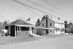
Post office in Woodvale, Autumn 1989 | |
 | |
| Location | Roughly bounded by Ash, High, North, Fulton and Broad Sts., in Woodvale, Broad Top Township, Wells Township, and Wood Township, Pennsylvania |
|---|---|
| Coordinates | 40°10′01″N 78°08′17″W / 40.16694°N 78.13806°WCoordinates: 40°10′01″N 78°08′17″W / 40.16694°N 78.13806°W |
| Area | 96 acres (39 ha) |
| Built | 1890, 1942 |
| Architectural style | Other, Vernacular workers' housing |
| Governing body | Federal |
| MPS | Industrial Resources of Huntingdon County, 1780--1939 MPS |
| NRHP Reference # | 92000942[1] |
| Added to NRHP | July 24, 1992 |
Woodvale Historic District is a national historic district located at Broad Top Township, Bedford County; Wells Township, Fulton County; and Wood Township, Huntingdon County, Pennsylvania. The district includes 79 contributing buildings, 1 contributing site, and 2 contributing structures in the coal mining community of Woodvale. The buildings date between about 1890 and 1942, and include industrial buildings, institutional buildings, and vernacular worker's housing. They were built by the Rockhill Iron and Coal Company. Non-residential buildings include the Methodist Church (1911), St. Michael's Greek Orthodox Church (1930s), a social hall, a mule barn, power house, railroad machine shop (1918), and post office (1919).[2]
It was added to the National Register of Historic Places in 1992.[1]
References
- ↑ 1.0 1.1 "National Register Information System". National Register of Historic Places. National Park Service. 2010-07-09.
- ↑ ""National Historic Landmarks & National Register of Historic Places in Pennsylvania"" (Searchable database). CRGIS: Cultural Resources Geographic Information System. Note: This includes R. Ann Safley (1992). "National Register of Historic Places Inventory Nomination Form: Woodvale Historic District" (PDF). Retrieved 2011-11-22.
| |||||||||||||||||||||||||

