Woodton
| Woodton | |
 Woodton |
|
| Area | 8.85 km2 (3.42 sq mi) |
|---|---|
| Population | 472 |
| – density | 53/km2 (140/sq mi) |
| OS grid reference | TM292939 |
| Civil parish | Woodton |
| District | South Norfolk |
| Shire county | Norfolk |
| Region | East |
| Country | England |
| Sovereign state | United Kingdom |
| Post town | BUNGAY |
| Postcode district | NR35 |
| Police | Norfolk |
| Fire | Norfolk |
| Ambulance | East of England |
| EU Parliament | East of England |
Coordinates: 52°29′41″N 1°22′30″E / 52.49482°N 1.37497°E
Woodton is a village and civil parish in the English county of Norfolk. It is situated some 7 km north-west of the Suffolk town of Bungay, and 20 km south-east of Norfolk's capital city of Norwich.
The civil parish has an area of 8.85 km2 (3.42 sq mi) and in the 2001 census had a population of 472 in 194 households. For the purposes of local government, the parish falls within the district of South Norfolk.
The village's name indicates a settlement in the woods. Over the years different variants of the name have been used, including Wdetuna, Wodetuna, Wodetone, Wudetuna, Uidetuna and Wootton. A number of bronze age ring ditches dating from between the 23rd century BC and the 7th century BC have been identified in the area.
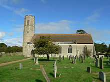
The church of Woodton All Saints is one of 124 existing round-tower churches in Norfolk.
References
- ^ Ordnance Survey (2005). OS Explorer Map OL40 - The Broads. ISBN 0-319-23769-9.
- ^ Office for National Statistics & Norfolk County Council (2001). Census population and household counts for unparished urban areas and all parishes. Retrieved December 2, 2005.
- ^ Woodton.info (2005). Woodton history. Retrieved December 16, 2005.
External links
| Wikimedia Commons has media related to Woodton. |
- Map sources for Woodton.
- Information from Genuki Norfolk on Woodton.
- Village web site for Woodton.
- Website with photos of Woodton All Saints, a round-tower church