Woodsville Brook
| Woodsville Brook | |
|---|---|
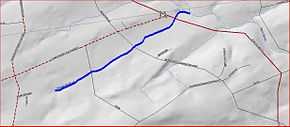 Map of Woodsville Brook | |
| Origin | 40°22′8″N 74°50′27″W / 40.36889°N 74.84083°W |
| Mouth | 40°23′2″N 74°48′55″W / 40.38389°N 74.81528°W |
| Progression | Stony Brook (Millstone River), Millstone River, Raritan River, Atlantic Ocean |
| Basin countries | United States |
| Mouth elevation | 197 ft (60 m) |
| River system | Raritan River system |
Woodsville Brook is a tributary of the Stony Brook in Mercer County, New Jersey in the United States.
Course
Woodsville Brook starts at 40°22′8″N 74°50′27″W / 40.36889°N 74.84083°W.[1] It flows northeast, crossing New Road and Marshalls Corner Woodsville Road. It then crosses Route 31 (Pennington Road) and Route 518 (Lambertville Hopewell Road) near to their intersection before joining the Stony Brook at 40°23′2″N 74°48′55″W / 40.38389°N 74.81528°W.[1]
Sister tributaries
See also
References
- ↑ 1.0 1.1 "GNIS Detail - Woodsville Brook". USGS. Retrieved 22 July 2010.