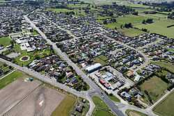
Woodend, New Zealand
| Woodend | |
|---|---|
| Minor urban area | |
|
Woodend in 2010 | |
 Woodend | |
| Coordinates: 43°19′S 172°40′E / 43.317°S 172.667°ECoordinates: 43°19′S 172°40′E / 43.317°S 172.667°E | |
| Country | New Zealand |
| Region | Canterbury |
| Territorial authority | Waimakariri District |
| Area | |
| • Total | 5.09 km2 (1.97 sq mi) |
| Population (June 2014 estimate)[1] | |
| • Total | 2,940 |
| • Density | 580/km2 (1,500/sq mi) |
| Postcode | 7610 |
Woodend is a town in the Waimakariri District, in the Canterbury Region of New Zealand's South Island. It is named after one of New Zealand's early settlers, Thomas Woodend.
The town has a population of 2,940 (June 2014 estimate).[1] It is 25 kilometres (16 mi) north of central Christchurch, and is a satellite town of the city; at the 2006 Census, 63% of employed Woodend residents worked in Christchurch.[2]
Woodend is in the Waimakariri District with both the Waimakariri and Ashley Rivers running either side. Close by Pegasus Bay and Pegasus Town. There are planned subdivisions at Ravenswood[3] and Tuahiwi with a Catholic primary and high schools to be named after Pope Benedict XVI and a shopping centre planned on Wards Road.
Education
Woodend School is Woodend's only school. It is a state co-educational full primary school[4] with a decile rating of 8 and a roll of 333 students (as of March 2015).[5] The principal is Graeme Barber.
References
- ↑ 1.0 1.1 "Subnational Population Estimates: At 30 June 2014 (provisional)". Statistics New Zealand. 22 October 2014. Retrieved 2 November 2014. Also "Infoshare; Group: Population Estimates - DPE; Table: Estimated Resident Population for Urban Areas, at 30 June (1996+) (Annual-Jun)". Statistics New Zealand. 22 October 2014. Retrieved 2 November 2014.
- ↑ "Commuting patterns in Christchurch -- Commuting patterns in New Zealand, 1996-2006". Statistics New Zealand. Retrieved 17 December 2014.
- ↑ http://www.waimakariri.govt.nz/services/planning-resource-consents/district_plan/district-plan-changes/private-district-plan-changes.aspx#PC7
- ↑ Te Kete Ipurangi schools database: Woodend School
- ↑ "Directory of Schools - as at 7 April 2015". New Zealand Ministry of Education. Retrieved 2015-04-08.
| ||||||||||||||||||||||||||||||||||||||||||||||||||||||||||||||||||||||||||||||
