Wood Island (MBTA station)
WOOD ISLAND | |||||||||||
|---|---|---|---|---|---|---|---|---|---|---|---|
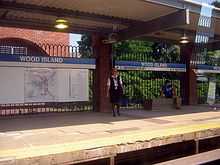
 Wood Island station in January 2013 | |||||||||||
| Location |
450 Bennington St, East Boston, Massachusetts 02128 | ||||||||||
| Coordinates | 42°22′47″N 71°01′23″W / 42.3797°N 71.0230°WCoordinates: 42°22′47″N 71°01′23″W / 42.3797°N 71.0230°W | ||||||||||
| Owned by | Massachusetts Bay Transportation Authority | ||||||||||
| Line(s) | |||||||||||
| Platforms | 2 side platforms | ||||||||||
| Tracks | 2 | ||||||||||
| Construction | |||||||||||
| Parking | none | ||||||||||
| Bicycle facilities | 10 | ||||||||||
| Disabled access | Yes | ||||||||||
| History | |||||||||||
| Opened | January 5, 1952[1] | ||||||||||
| Previous names |
Day Square(1952-1954) Wood Island Park (1954-1967)[1] | ||||||||||
| Traffic | |||||||||||
| Passengers (2013) | 2,507 (weekday average boardings)[2] | ||||||||||
| Services | |||||||||||
| |||||||||||
Wood Island is a grade-level rapid transit station on the MBTA Blue Line, located off Bennington Street (Route 145) in the Day Square section of East Boston, Massachusetts. The station also serves as a bus transfer point for several local MBTA Bus routes.
The station is adjacent to the former Wood Island Park, a once heavily used recreational area for East Boston residents. Most of the park was destroyed in the middle 1960s to expand Logan International Airport.
History
Predecessor stations

Wood Island was originally a station on the Boston, Revere Beach & Lynn Railroad, located at Prescott Street in what was then the Wood Island neighborhood, approximately at 42°22′28.6″N 71°1′25.45″W / 42.374611°N 71.0237361°W.[3] It opened along with the rest of the line in 1874, with service near rapid transit frequency for decades. The station was abandoned when the BRB&L ceased operations in 1940, and demolished several years later during expansion of Logan Airport. The station site is now occupied by aviation support businesses.
Harbor View, the next station to the northeast, was located at Short Street at 42°22′51.36″N 71°0′58.14″W / 42.3809333°N 71.0161500°W.[3] Harbor View was a boxy station of identical design to Wood Island. Located a short walk from Bennington Street, it lost much of its ridership to East Boston Tunnel trolleys, and was closed significantly sooner than the rest of the BRB&L. The building was sold and moved closer to Cowper Street, and is today a private residence.[4]
Rapid transit
In 1941, the Boston Elevated Railway bought the BRB&L right-of-way to Wonderland for use as a high-speed trolley line similar to the Ashmont-Mattapan High Speed Line. However, the BERy's financial woes delayed construction. In 1947, the Metropolitan Transit Agency instead decided to build an extension of the rapid transit East Boston Tunnel line, with construction beginning in 1948.[4] Day Square station was built on a new section of right-of-way, which connected the former Eastern Railroad's East Boston Branch (used by the extension as far as Airport Station) with the BRB&L at Harbor View. Day Square was located between the former Wood Island and Harbor View stations, serving Day Square and the Neptune Road / Wood Island Park development designed by Frederick Law Olmsted.
.jpg)
Day Square station had its platforms at ground level, with an elevated busway for buses and trackless trolleys located above the platforms. A loop for these vehicles extended over a parking lot south of the station.[4] The extension to Airport, Day Square, and Orient Heights opened on January 5, 1952, with further completion to Wonderland in 1954.[1]
Day Square station was renamed Wood Island Park on October 21, 1954.[1] In early 1967, as part of a series of station name changes, Wood Island Park was changed again to Wood Island, as Wood Island Park had been destroyed during the expansion of Logan Airport.[1] The loop of the elevated busway was removed in the 1970s.
Modernization
The Blue Line Modernization Project, which began in the 1990s and is still under way, includes renovating stations to increase the length of trains from four to six cars, to make all stations wheelchair accessible, and to improve appearance. On June 25, 1994, the line was cut back to Orient Heights at all times to permit reconstruction of the outer stations. Beachmont and Wood Island were completely rebuilt, while Suffolk Downs, Revere Beach, and Wonderland were renovated.[5] The busway, in poor shape from deferred maintenance, was removed in February 1994 and replaced with a surface busway north of the station, which is now fully open-air. The stations reopened on June 26, 1995.[6][1] The station's two platforms on either side of two tracks are now connected by an overhead walkway within the paid zone.
Wood Island was closed from July 7 to September 5, 2008, for a renovation of both platforms. The platforms installed during the 1994 construction on the outer stations had not aged well, and were replaced during a series of short-term closures in 2008. Shuttle buses ran from Airport Station in lieu of subway service.[1]
Bus connections
Three MBTA Bus routes stop at the Wood Island busway; the 112 and 121 routes terminate there.
- 112: Wellington Station - Wood Island Station via Central Avenue, Mystic Mall & Admiral's Hill
- 120: Orient Heights Station - Maverick Station via Bennington Street, Jeffries Point & Waldemar Loop
- 121: Wood Island Station - Maverick Station via Lexington Street
Platform layout
| Platform level | Side platform, doors will open on the right | |
| Southbound | ← Blue Line toward Bowdoin or Government Center (Airport) | |
| Northbound | → Blue Line toward Wonderland (Orient Heights) → | |
| Ground | - | Exit/Entrance |
References
- ↑ 1.0 1.1 1.2 1.3 1.4 1.5 1.6 Belcher, Jonathan (22 March 2014). "Changes to Transit Service in the MBTA district" (PDF). NETransit. Retrieved 1 June 2014.
- ↑ "Ridership and Service Statistics" (PDF) (14 ed.). Massachusetts Bay Transportation Authority. 2014. Retrieved 1 June 2014.
- ↑ 3.0 3.1 "Outline and Index Map of East Boston Wards 1 & 2". Atlas of the City of Boston, Vol. 9, East Boston. G.W. Bromley and Co. 1892. Retrieved 26 May 2014.
- ↑ 4.0 4.1 4.2 Cheney, Frank (2003). Boston's Blue Line. Arcadia Publishing. pp. 8, 63, 88–90. ISBN 9780738535760.
- ↑ Blake, Andrew (20 March 1994). "MBTA to begin $467 million Blue Line project". Boston Globe. Retrieved 26 January 2014 – via Highbeam Research. (subscription required (help)).
- ↑ Blake, Andrew (18 June 1995). "Blue Line stations set to reopen after $467m upgrade". Boston Globe. Retrieved 26 January 2014 – via Highbeam Research. (subscription required (help)).
External links
| Wikimedia Commons has media related to Wood Island (MBTA station). |
| ||||||||||||||||||||||||||||||||||||||||||||||||||||||||||