Wolli Creek Regional Park
| Wolli Creek Regional Park | |
|---|---|
|
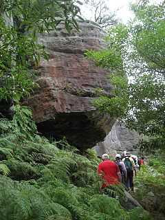
Sandstone Outcrop along Two Valley Trail. | |
| Type | Nature reserve |
| Location | Sydney, New South Wales, Australia |
| Nearest city | Rockdale |
| Coordinates | 33°56′S 151°08′E / 33.933°S 151.133°ECoordinates: 33°56′S 151°08′E / 33.933°S 151.133°E[1] |
| Area | 50 hectares (120 acres) |
| Operated by | NSW National Parks & Wildlife Service |
| Status | Open |
The Wolli Creek Regional Park is a 50 hectares (120 acres) regional park,[2] located adjacent to Wolli Creek within the Wolli Creek Valley, between Bexley North and Tempe in south-west Sydney, New South Wales, Australia.
The park was announced by the NSW Government in 1998 as a result of sustained community campaigning for the area to be preserved and for the M5 East Freeway to go underground.[2] Whilst some of the park has been formed and management handed over from local government authorities to the NSW National Parks & Wildlife Service, including the 8.9 hectares (22 acres) Girrahween Park,[2] Turrella Reserve, and some privately held land that was compulsorily acquired,[3] some areas of the originally planned park remain in the hands of government agencies including Sydney Water and Roads and Maritime Services.[2]
When complete, the planned nature reserve will offer easy public transport access, family picnic areas, extensive views and bushland, rugged sandstone escarpments with walking tracks, a mixture of parkland, heathland, and woodland forest, and great birdwatching within close proximity to heavily developed residential and industrial landscape.[4]
Bushland
The vegetation of the park along the Wolli Creek is maintained also by the Wolli Creek Preservation Society whose volunteers engage in a variety of activities, including bush regeneration.[3][5][6] The park supports a great diversity of native plants and animals, including birds and Grey-headed flying foxes, and provides exceptional recreational opportunities for local residents and visitors.[2]
Recreation
Bushwalkers and birdwatchers can enjoy the valley using the Two Valley Trail, and reserves such as Girrawheen Park and Turrella Reserve invite for picnics and other recreational activities. Access to the park is available through adjacent suburban streets and railway stations located at Tempe, Turrella, Bardwell Park, and Bexley North.[5]
Gallery
-
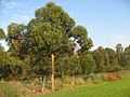
Bush regeneration Bray Avenue, Earlwood, NSW.
-
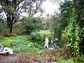
Bush regeneration planting site along Wolli Creek, Turrella Reserve.
References
- ↑ "Wolli Creek Regional Park". Geographical Names Register (GNR) of NSW. Geographical Names Board of New South Wales. Retrieved 8 April 2013.
- ↑ 2.0 2.1 2.2 2.3 2.4 "Regional park". Wolli Creek Preservation Society Inc. 17 February 2012. Retrieved 8 April 2013.
- ↑ 3.0 3.1 Vella, Joanne (14 September 2010). "Land rezoned for Wolli Creek regional park". Canterbury-Bankstown Express. Retrieved 8 April 2013.
- ↑ "Inner south-west Sydney’s precious greenspace". Wolli Creek Preservation Society Inc. 21 February 2013. Retrieved 8 April 2013.
- ↑ 5.0 5.1 "Wolli Creek Regional Park". NSW National Parks & Wildlife Service. Government of New South Wales. Retrieved 8 April 2013.
- ↑ "Wolli Creek Regional Park". Office of Environment and Heritage. Government of New South Wales. Retrieved 8 April 2013.