Wollaston, Western Australia
| Wollaston Bunbury, Western Australia | |||||||||||||
|---|---|---|---|---|---|---|---|---|---|---|---|---|---|
|
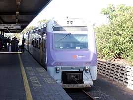
Transwa Australind train at Bunbury Passenger Terminal, Wollaston | |||||||||||||
| Population | 1,407 (2001 Census)[1] | ||||||||||||
| • Density | 1,010/km2 (2,600/sq mi) | ||||||||||||
| Established | 1840s | ||||||||||||
| Postcode(s) | 6230 | ||||||||||||
| Area | 1.4 km2 (0.5 sq mi) | ||||||||||||
| Location | 4 km (2 mi) from Bunbury | ||||||||||||
| LGA(s) | City of Bunbury | ||||||||||||
| State electorate(s) | Bunbury | ||||||||||||
| Federal Division(s) | Forrest | ||||||||||||
| |||||||||||||
Coordinates: 33°20′29″S 115°39′39″E / 33.3414°S 115.6608°E
Wollaston is an inner southeastern suburb of Bunbury, Western Australia 4 km from the centre of Bunbury. Its local government area is the City of Bunbury.
It is the location of the Bunbury Passenger Terminal, the current terminus for the South Western Railway and the Australind railway service.
History
The suburb's name honours Rev. John Ramsden Wollaston (1790-1856), who initially migrated privately to be the chaplain for the Western Australian Land Company's failed settlement scheme at Australind. Finding himself without a parish, together with his sons, he built a small timber chapel on his own land at "Charterhouse" alongside the Preston River, as a condition of his receiving a stipend to act as Colonial Chaplain, and was opened without consecration in September 1842 (it had to wait until 1969 for this). A churchyard was built alongside it which contains the graves of some of the Bunbury area's pioneers.[2]
Suburban development in the area took place in the 1950s and 1960s.
Geography
Wollaston is bounded by Sandridge Road to the north, Robertson Drive and the Preston River to the east, and the railway to the south. The suburb is mostly residential, although a light industrial area extending from central Bunbury exists west of King Road and the Horseshoe Lake, a remnant oxbow lake is located within the suburb opposite the Bunbury Forum shopping centre. The suburb contains a diverse mix of residents, with a strong emphasis on trades, retail and services, and over 15% of its population are of Italian descent.[1]
Facilities
Wollaston is next to Bunbury Forum, one of Bunbury's two main shopping centres, and also contains a small neighbourhood shopping centre. The suburb contains no primary schools, although three are located within 800 m. Bunbury Catholic College, established in 1973 after the amalgamation of Marist Brother's St Fraancis Xaviers College (situated on the current BCC site and opened in 1954) and the Mercy Sister's St Josephs College (situated at the now Bunbury Regional Art Gallery, originally opened in 1897) and with a student population of about 1000, and the historic St Mark's Anglican Church (1842) are located within the suburb.
Transport
Wollaston is also the terminus of the Transwa Australind rail service. The Bunbury railway station|Bunbury Passenger Terminal]] was constructed at Wollaston in 1983-1985 to replace the central railway station (now the Bunbury Visitor Centre and bus station).
The last train to use the old station departed Bunbury on 28 May 1985, and the new terminal commenced operations the following day. The Australind passenger service was subsequently upgraded in 1987.
At present there are two departures and two arrivals at Wollaston every day of the week.[3] The 101 and 103 Bunbury City Transit routes depart for the city centre regularly, with a journey time of 15–20 minutes.[4] Both of these services are free of charge to those connecting to/from Bunbury from the Australind train.
All services are operated by the Public Transport Authority.
References
- ↑ 1.0 1.1 Main Areas - Bunbury (CCD 5050203, 5050204, 5050207) - Australian Bureau of Statistics, 2001. Accessed 25 December 2006.
- ↑ "Register of Heritage Places - St Mark's Anglican Church, Picton" (PDF). 5 November 1996. Archived from the original (PDF) on 2006-08-23. Retrieved 2006-11-11.
- ↑ Australind Timetable (PDF), Transwa, effective 16 March 2004. Accessed 25 December 2006.
- ↑ Bunbury 1 (PDF), TransBunbury, effective 27 July 2014. Accessed 6 October 2014.
| ||||||||||