Wolfenschiessen
| Wolfenschiessen | ||
|---|---|---|
|
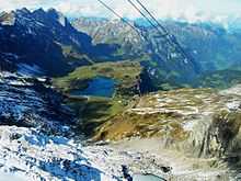
Trübsee | ||
| ||
 Wolfenschiessen | ||
|
Location of Wolfenschiessen 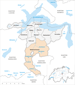 | ||
| Coordinates: 46°54′N 8°23′E / 46.900°N 8.383°ECoordinates: 46°54′N 8°23′E / 46.900°N 8.383°E | ||
| Country | Switzerland | |
| Canton | Nidwalden | |
| District | n.a. | |
| Area[1] | ||
| • Total | 92.77 km2 (35.82 sq mi) | |
| Elevation (Wolfenschiessen village) | 510 m (1,670 ft) | |
| Highest elevation (Titlis Glacier) | 2,880 m (9,450 ft) | |
| Lowest elevation (Niederrickenbach Station) | 488 m (1,601 ft) | |
| Population (Dec 2013[2]) | ||
| • Total | 2,101 | |
| • Density | 23/km2 (59/sq mi) | |
| Postal code | 6386 | |
| SFOS number | 1511 | |
| Surrounded by | Beckenried, Dallenwil, Engelberg (OW), Innertkirchen (BE), Isenthal (UR), Kerns (OW), Oberdorf | |
| Website |
www SFSO statistics | |


Wolfenschiessen is a village and municipality in the canton of Nidwalden in Switzerland. Besides the village of Wolfenschiessen itself, the municipality includes the settlements of Altzellen, Büren ob dem Bach, Dörfli and Oberrickenbach, together with a large area of high alpine land, mountains, lakes and glaciers.[3]
Coat of arms
The municipality's coat of arms is Azure, a Wolf rampant Argent pierced by an Arrow in bend sinister Or. This is an example of canting where the name of the municipality is translated or represented on the coat of arms. In this case, Wolfenschiessen means "to shoot the wolf."[4]
Geography
Wolfenshiessen encompasses both sides of the deep valley of the Engelberger Aa river downstream of Engelberg, with high alpine areas encircling Engelberg to the north, west and south. The settlements of Wolfenschiessen, Büren ob dem Bach and Dörfli lie in the valley, whilst Altzellen and Oberrickenbach are on higher ground to the east.[3]
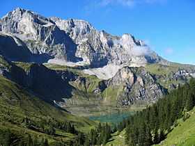
The lake of Bannalpsee lies above Oberrickenbach to the north of Engelberg, whilst Trübsee is on high ground to the south of Engelberg. In its far southern corner, the municipality reaches high up the flank of Mount Titlis, including part of the Titlis Glacier (Titlisgletscher).[3]
Wolfenschiessen has an area, as of 2006, of 92.8 km2 (35.8 sq mi). Of this area, 40.8% is used for agricultural purposes, while 33% is forested. Of the rest of the land, 1.2% is settled (buildings or roads) and the remainder (24.9%) is non-productive (rivers, glaciers or mountains).[5]
Demographics
Wolfenschiessen has a population (as of 31 December 2013) of 2,101.[2] As of 2007, 9.7% of the population was made up of foreign nationals.[6] Over the last 10 years the population has grown at a rate of 0.3%. Most of the population (as of 2000) speaks German (93.6%), with Albanian being second most common ( 2.7%) and Serbo-Croatian being third ( 1.4%).[5] As of 2008 the gender distribution of the population was 51.7% male and 48.3% female.
As of 2000 there are 674 households, of which 348 households (or about 51.6%) contain only one or two individuals. 111 or about 16.5% are large households, with at least five members.[7]
In the 2007 federal election the most popular party was the FDP which received 89.3% of the vote. The next two most popular parties were the local, small right-wing parties (10.7%) and the SPS (0.1%).[5]
In Wolfenschiessen about 58.6% of the population (between age 25-64) have completed either non-mandatory upper secondary education or additional higher education (either university or a Fachhochschule).[5]
Wolfenschiessen has an unemployment rate of 0.88%. As of 2005, there were 228 people employed in the primary economic sector and about 94 businesses involved in this sector. 138 people are employed in the secondary sector and there are 26 businesses in this sector. 268 people are employed in the tertiary sector, with 61 businesses in this sector.[5]
The historical population is given in the following table:[7]
| year | population |
|---|---|
| 1960 | 1,647 |
| 1970 | 1,470 |
| 1980 | 1,524 |
| 1990 | 1,765 |
| 2000 | 2,041 |
| 2005 | 1,999 |
Transport
The municipality of Dallenwil is served by three railway stations on the Luzern–Stans–Engelberg line. Besides Wolfenschiessen station itself, there is Niederrickenbach station to the north and Dörfli station to the south. The hourly InterRegio service between Lucerne and Engelberg stops at all three stations.[8]
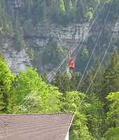
A post bus service within the municipality links the villages of Wolfenschiessen and Oberrickenbach, with eight services per day. From Oberrickenbach, an cable car rises to the Bannalpsee.[3][9]
The lake of Trübsee is an intermediate stop on the cable car system that links Engelberg and the summit of Mount Titlis.[3]
Sights
The main sights of Wolfenschiessen are: the parish church St. Maria, the chapel St. Joder in Altzellen, the mansions Hechhuis, and the Grossitz mansion.
References
- ↑ Arealstatistik Standard - Gemeindedaten nach 4 Hauptbereichen
- ↑ 2.0 2.1 Swiss Federal Statistics Office – STAT-TAB Ständige und Nichtständige Wohnbevölkerung nach Region, Geschlecht, Nationalität und Alter (German) accessed 18 August 2014
- ↑ 3.0 3.1 3.2 3.3 3.4 map.geo.admin.ch (Map). Swiss Confederation. Retrieved 2013-01-08.
- ↑ Flags of the World-Wolfenschiessen accessed 4 September 2009
- ↑ 5.0 5.1 5.2 5.3 5.4 Swiss Federal Statistical Office accessed 04-Sep-2009
- ↑ Nidwalden Statistical Office-Population (German) accessed 4 September 2009
- ↑ 7.0 7.1 Nidwalden Statistical Office-Municipalities (German) accessed 4 September 2009
- ↑ "Luzern–Stans–Engelberg" (PDF). Bundesamt für Verkehr. Retrieved 2013-01-14.
- ↑ "Wolfenschiessen–Oberrickenbach (Linie 331)" (PDF). Bundesamt für Verkehr. Retrieved 2013-01-22.
| Wikimedia Commons has media related to Wolfenschiessen. |
| ||||||||