Windhoek
| Windhoek Windhuk, ǀAiǁGams, Otjomuise | ||
|---|---|---|
| City | ||
 | ||
| ||
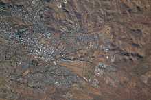
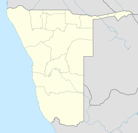 Windhoek Location in Namibia | ||
| Coordinates: 22°34′12″S 17°5′1″E / 22.57000°S 17.08361°ECoordinates: 22°34′12″S 17°5′1″E / 22.57000°S 17.08361°E | ||
| Country |
| |
| Region | Khomas Region | |
| Established | 18 October 1890 | |
| Government | ||
| • Mayor | Agnes Kafula[1] | |
| • Deputy Mayor | Muezee Kazapua[1] | |
| Area | ||
| • Total | 1,982 sq mi (5,133 km2) | |
| Population (2014) | ||
| • Total | 322,500 | |
| • Density | 163/sq mi (62.8/km2) | |
| Time zone | WAT (UTC+1) | |
| • Summer (DST) | WAST (UTC+2) | |
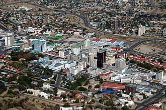
Windhoek (/ˈvɪnt.hʊk/ VINT-huuk; German: ![]() Windhuk ; Khoekhoe: ǀAiǁgams; Otjiherero: Otjomuise) is the capital and largest city of the Republic of Namibia. It is located in central Namibia in the Khomas Highland plateau area, at around 1,700 metres (5,600 ft) above sea level. The population of Windhoek in 2012 was 322,500 and grows continually due to an influx from all over Namibia.
Windhuk ; Khoekhoe: ǀAiǁgams; Otjiherero: Otjomuise) is the capital and largest city of the Republic of Namibia. It is located in central Namibia in the Khomas Highland plateau area, at around 1,700 metres (5,600 ft) above sea level. The population of Windhoek in 2012 was 322,500 and grows continually due to an influx from all over Namibia.
The town developed at the site of a permanent spring known to the indigenous pastoral communities. It developed rapidly after Jonker Afrikaner, Captain of the Orlam settled here in 1840 and built a stone church for his community. However, in the decades thereafter multiple wars and hostilities led to the neglect and destruction of the new settlement such that Windhoek was founded a second time in 1890 by Imperial German army Major Curt von François.
Windhoek is the social, economic, political, and cultural centre of the country. Nearly every Namibian national enterprise, governmental body, educational and cultural institution is headquartered there.
History
Etymology
The City of Windhoek is traditionally known by two names: ǀAiǁGams, (Khoekhoe: hot springs) and Otjomuise[2] (Otjiherero: place of steam). Both traditional names reference the hot springs near today's city centre.
Theories vary on how the place got its modern name of Windhoek. Most believe it is derived from the Afrikaans word Wind-Hoek (wind corner). Another theory suggests that Captain Jonker Afrikaner named Windhoek after the Winterhoek Mountains at Tulbagh in South Africa, where his ancestors had lived. The first mention of the name Windhoek occurred in a letter from Jonker Afrikaner to Joseph Tindall, dated 12 August 1844.[3]
Pre-colonial
Around 1840, Jonker Afrikaner established a settlement at Windhoek.[4] He and his followers stayed near one of the main hot springs, located in the present-day Klein Windhoek suburb. He built a stone church that held 500 people, which was also used as a school. Two Rhenish missionaries, Carl Hugo Hahn and Franz Heinrich Kleinschmidt, started working there in late 1842 and were two years later driven out[5] by two Wesleyans, Richard Haddy and Joseph Tindall.[6] Gardens were laid out and for a while Windhoek prospered, but wars between the Nama and Herero eventually destroyed the settlement. After a long absence, Hahn visited Windhoek again in 1873 and was dismayed to see that nothing remained of the town's former prosperity. In June 1885, a Swiss botanist found only jackals and starving guinea fowl amongst neglected fruit trees.[7]
Colonial era

In 1878, Britain annexed Walvis Bay and incorporated it into the Cape of Good Hope in 1884, but Britain did not extend its influence into the hinterland. A request by merchants from Lüderitzbucht resulted in the declaration of a German protectorate over German South-West Africa in 1884. The German colony came into being with the determination of its borders in 1890 and Germany sent a protective corps, called the Schutztruppe under Major Curt von François, to maintain order. Von François stationed his garrison at Windhoek, which was strategically situated as a buffer between the Nama and Herero, while the twelve strong springs provided water for the cultivation of food.
Present-day Windhoek was founded on 18 October 1890, when Von François fixed the foundation stone of the fort, which is now known as the Alte Feste (Old Fortress).[8] After 1907, development accelerated as people migrated from the countryside to the city. There was also a larger influx of European settlers arriving from Germany and South Africa. Businesses were erected on Kaiser Street (presently Independence Avenue), and along the dominant mountain ridge over the city. At this time, Windhoek's three castles, Heinitzburg, Sanderburg, and Schwerinsburg, were built.
South African administration after World War I
The German colonial era came to an end during World War I when South African troops occupied Windhoek in May 1915 on behalf of the British Empire. For the next five years, a military government administered South West Africa. Development of the city of Windhoek and the nation later to be known as Namibia came to a virtual standstill. After World War II, Windhoek's development gradually gained momentum, as more capital became available to improve the area's economic climate. After 1955, large public projects were undertaken, such as the building of new schools and hospitals, tarring of the city's roads (a project begun in 1928 with Kaiser Street), and the building of dams and pipelines to finally stabilise the water supply.[7] It also introduced the World's first potable re-use plant in 1958, treating recycled sewage and sending it directly into the town's water supply.[9]
Since Namibian independence
With Namibia's independence from South African administration in 1990, Windhoek was recognised as the capital city of South-West Africa as administered by the South African government. It continues to be the capital city of the Republic of Namibia, as well as the provincial capital of the central Khomas Region. Since then the city experienced accelerated growth and development.
Geography
It sits on a sloping plain on the northern side of the Khomas Hochland (Khomas Highlands) in the Windhoek Basin valley which extends in north-southern direction for about 80 kilometres (50 mi) towards the city of Okahandja. The mean altitude of Windhoek is 1,657 metres (5,436 ft).
Expanding the town area has – apart from financial restrictions – proven to be challenging due to its geographical location. In southern, eastern and western directions Windhoek is surrounded by rocky, mountainous areas which make land development costly. The southern side is not suitable for industrial development because of the presence of underground aquifers. This leaves the vast Brakwater area north of town the only feasible place for Windhoek's expansion.[10]
Nevertheless, Windhoek's City Council has plans of dramatically expanding the city's boundaries such that the town area will cover 5,133.4 square kilometres (1,982.0 sq mi). This will make Windhoek the third-largest city in the world by area, after Tianjin and Istanbul, although the population density is only 63 inhabitants per square kilometre.[11]
Suburbs
Windhoek is divided into different suburbs:[12]
- Academia
- Auasblick
- Avis
- Cimbebasia
- Dorado Park
- Eros
- Eros Park
- Greenwell Matongo
- Goreangab
- Hakahana
- Havanna
- Hochland Park
- Katutura
- Khomasdal
- Kleine Kuppe
- Klein-Windhoek
- Lafrenz Industrial Area
- Ludwigsdorf
- Luxury Hill
- Northern Industrial
- Okuryangava
- Olympia
- Otjomuise
- Pionierspark
- Prosperita
- Rocky Crest
- Southern Industrial
- Suiderhof
- Wanaheda
- Windhoek Central
- Windhoek North
- Windhoek West
Climate
Windhoek is situated in a semi-arid climatic region (Köppen: BSh). Days are mostly warm with very hot days during the summer months, while nights are generally cool. The average annual temperature is 19.47 °C (67.05 °F), which is high for a site at such a high altitude on the edge of the tropics.[13] This is mainly due to the prevalence of a warm northerly airflow and the mountains to the south, which shelter the city from cold southerly winds.
The winter months of June, July and August usually experience little or no rain. Minimum temperatures in winter range between −5 and 18 °C (23 and 64 °F). Nights are usually cool, and very cold before dawn. It almost never snows. Days are usually warm to hot, varying from a maximum of 20 °C (68 °F) in July to 31 °C (88 °F) in January.
Although the 2010/2011 rainy season brought a record of over 1,000 millimetres (39 in), mean annual rainfall is around 360 millimetres (14 in),[14] which is too low to support crops or gardens without heavy use of watering. The natural vegetation of the area is scrub and steppe. Droughts are a regular occurrence, with the two worst rainy seasons of recent history, 1981/82 and 2012/13, yielding 126 millimetres (5.0 in) and 166 millimetres (6.5 in) respectively.[15]
| Climate data for Windhoek, Namibia | |||||||||||||
|---|---|---|---|---|---|---|---|---|---|---|---|---|---|
| Month | Jan | Feb | Mar | Apr | May | Jun | Jul | Aug | Sep | Oct | Nov | Dec | Year |
| Record high °C (°F) | 36 (97) |
34 (93) |
34 (93) |
31 (88) |
32 (90) |
26 (79) |
25 (77) |
29 (84) |
33 (91) |
34 (93) |
36 (97) |
36 (97) |
36 (97) |
| Average high °C (°F) | 30.5 (86.9) |
29.1 (84.4) |
27.8 (82) |
26.2 (79.2) |
23.7 (74.7) |
21.0 (69.8) |
21.3 (70.3) |
23.9 (75) |
27.6 (81.7) |
29.7 (85.5) |
30.4 (86.7) |
31.6 (88.9) |
26.9 (80.43) |
| Average low °C (°F) | 17.8 (64) |
17.2 (63) |
16.1 (61) |
13.2 (55.8) |
10 (50) |
7.1 (44.8) |
7.0 (44.6) |
9.0 (48.2) |
12.6 (54.7) |
15.0 (59) |
16.2 (61.2) |
17.3 (63.1) |
13.21 (55.78) |
| Record low °C (°F) | 9 (48) |
7 (45) |
4 (39) |
2 (36) |
−2 (28) |
−3 (27) |
−3 (27) |
−4 (25) |
−1 (30) |
2 (36) |
1 (34) |
3 (37) |
−4 (25) |
| Average precipitation mm (inches) | 91.3 (3.594) |
87.0 (3.425) |
69.5 (2.736) |
32.3 (1.272) |
6.2 (0.244) |
1.2 (0.047) |
0.4 (0.016) |
0.8 (0.031) |
3.8 (0.15) |
11.4 (0.449) |
25.7 (1.012) |
33.2 (1.307) |
362.8 (14.283) |
| Average relative humidity (%) | 45 | 53 | 58 | 54 | 45 | 43 | 38 | 30 | 26 | 28 | 31 | 36 | 40.6 |
| Source #1: BBC Weather[16] | |||||||||||||
| Source #2: Ministry of Works and Transport (Meteorological Service Division)
[1.pdf "Ministry of Works & Transport: Tabulation of Climate Statistics for Selected Stations in Namibia"] (PDF). 2012. | |||||||||||||
Demographics
In 1971, there were roughly 26,000 whites living in Windhoek, outnumbering the black population of 24,000. About one third of white residents at the time, at least 9,000 individuals, were German speakers.[17] Windhoek's population currently stands at over 322,500 (65% Black; 17% whites; 18% other), and is growing 4% annually in part due to informal settlements that have even higher growth rates of nearly 10% a year.[10]
Economy
The city is the administrative, commercial, and industrial center of Namibia. A 1992/93 study estimated that Windhoek provides over half of Namibia's non-agricultural employment, with its national share of employment in utilities being 96%, in transport and communication 94%, finance and business services 82%.[18] Due to its relative size[19] Windhoek is, even more than many other national capital cities, the social, economic, and cultural centre of the country. Nearly every national enterprise is headquartered here. The University of Namibia is, too, as are the country's only theatre, all ministry head offices, and all major media and financial entities.[20] The governmental budget of the city of Windhoek nearly equals those of all other Namibian local authorities combined.[21] Air Namibia has its main office in the Trans Namib Building in Windhoek.[22] Several shopping malls were built in the post-independence era, including Maerua Mall, and Wernhil Park Mall.
Culture
In public life Afrikaans and to a lesser extent German are still used as the lingua franca even though the government only uses the English language.[23]
Notable landmarks

- Alte Feste – (Old Fortress) Built in 1890, today houses the National Museum.
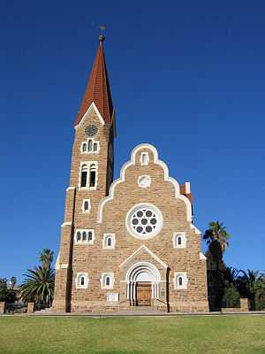
- Christuskirche – A Lutheran church opened in 1910, built in the gothic revival style with Art Nouveau elements. Situated in the historic center of Windhoek next to Parliament Gardens and Tintenpalast.[24]
- Heroes' Acre
- National Library of Namibia
- Reiterdenkmal (Equestrian Monument), a statue celebrating the victory of the German Empire over the Herero and Nama in the Herero and Namaqua War of 1904–1907[25] The statue has been removed from its historical place next to Christuskirche in December 2013 and is now on display in the yard of the Alte Feste.[26]
- St. Marien Kathedrale
- Supreme Court of Namibia – situated in Michael Scott Street on Eliakim Namundjebo Plaza. Built between 1994 and 1996[27] it is Windhoek's only building erected post-independence in an African style of architecture.[28]
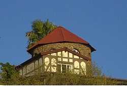
- The three castles of Windhoek built by architect Wilhelm Sander: Heinitzburg, Sanderburg, and Schwerinsburg[29]
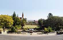
- Tintenpalast – (Ink Palace) within Parliament Gardens, the seat of both chambers of the Parliament of Namibia. Built between 1912 and 1913 and situated just north of Robert Mugabe Avenue.
- Turnhalle – neo-classicist building of Wilhelmine architecture, inaugurated in 1909.[30]
- Windhoek Public Library – built in 1925, next to the Alte Feste.[31]
- Windhoek Railway Station
- Zoo Park – a public park on Independence Avenue in downtown Windhoek. The current park is landscaped and features a pond, playground and open-air theatre.[32]
Transport
Rail
Windhoek is connected by rail to:
Road


In 1928, Kaiserstraße, now Independence Avenue, was the first paved road in Windhoek. Ten years later the next one, Gobabis road, now Sam Nujoma Drive, was also paved. Today out of ca. 40,000 kilometres (25,000 mi) of Namibia's total road network, about 5,000 kilometres (3,100 mi) is sealed.
Windhoek's three main access roads from Rehoboth, Gobabis, and Okahandja are paved, and are designed to be able to withstand the largest possible flood to be expected in fifty years. Sealed roads can carry traffic moving at 120 kilometres per hour (75 mph) and should last for 20 years.
As everywhere in Namibia, public transport is scarce and transportation across town is largely done by taxi; there were 6,492 registered taxis in 2013.[33]
Air transportation
Windhoek is served by two airports. The closest one is Eros 7 kilometres (4.3 mi) south of the city center for smaller craft, and Hosea Kutako International Airport 42 kilometres (26 mi) east of the city. A number of foreign airlines operate to and from Windhoek. Air charters and helicopter and fixed-wing aircraft rentals are also available.
Windhoek International Airport
Hosea Kutako International Airport, situated 45 kilometres outside Windhoek, handles well over 400,000 passengers a year. It has one runway without capacity limitations. Other international airports are located in Walvis Bay and Luderitz. It directly connects daily to Frankfurt. Southern Africa's hub, Johannesburg, is only a two-hour flight away, from where it is possible to connect to more than 50 cities. South African Airways, Air Berlin, and Air Namibia all have daily flights to Windhoek International Airport, whilst TAAG Angola Airlines has bi-weekly turnarounds to Luanda.
Eros Airport
Eros Airport is the busiest airport in Namibia in terms of take offs and landings.[34] This city airport handles around 12,000 individual flights a year, the majority of which are light aircraft. Primarily, limitations such as runway length, noise, and air space congestion have kept Eros from developing into a larger airport. Most of Namibia's charter operators have Eros as their base.
Sport
The city has several football clubs which include African Stars F.C., Black Africa F.C., F.C. Civics Windhoek, Orlando Pirates F.C., Ramblers F.C. and SK Windhoek.
Many boxers such as Paulus Moses, Paulus Ambunda and Abmerk Shindjuu are from the city.
The Namibia national cricket team plays the majority of its home games at the Wanderers Cricket Ground.[35] It has also played at other grounds in the city, including the United Ground and the Trans Namib Ground.[36][37]
The 'Tony Rust Raceway' is located west of Windhoek on the Daan Viljoen road, and reopened in 2007.[38]
Education
Tertiary Institutions
The general institutions of higher education in Windhoek are:
- University of Namibia (UNAM)
- Polytechnic of Namibia (Poly)
- International University of Management (IUM)
Secondary schools
- A Shipena High School
- Academia Secondary School
- Augustineum Secondary School
- Centaurus High School
- Concordia College
- Dagbreek Centre a school for the handicapped[39]
- David Bezuidenhout Secondary School
- Delta Secondary School
- Deutsche Höhere Privatschule (DHPS)
- Eldorado Secondary School
- Ella du Plessis Secondary School
- Eros School For Girls[40]
- Goreangab Secondary School
- Immanuel Shifidi High School
- Jan Jonker Afrikaner High School
- Jan Möhr High School
- Saint George's Diocesan College[40]
- Saint Paul's College
- Combretum Trust School
- Windhoek Afrikaanse Privaatskool (WAP)
- Windhoek Gymnasium Private School (WGPS)[41]
- Windhoek High School (WHS)
- Windhoek International School (WIS)
- Windhoek Technical High School (HTS)
Cooperation agreements
Windhoek has co-operation agreements and partnerships with the following towns:[42]
-
 Shanghai, since 1 June 1996
 -
 Richmond, since 20 March 1998
 -
 Wetzlar
 - Berlin, since 18 April 2000[43]
- Trossingen, since 3 October 2000
- Bremen, since 18 April 2000
-
 Douala, since 31 August 2000
 -
 Harare, since 8. November 2000
 -
 Gaborone, since 23 August 2001
 -
 Havana, since 23 October 2001
 -
 Eenhana, since 17 April 2002
 - Ongwediva, since 17 April 2002
- Ondangwa, since 17 April 2002
- Outapi, since 17 April 2002
- Oshakati, since 18 April 2002
-
 Lephalale, since 22 May 2002
 -
 Vantaa, since 13 August 2002
 - Walvis Bay, since 8 October 2002
- Mariental, since 11 March 2003
- Gibeon, since 11 March 2003
- Maltahöhe, since 12 April 2002
- Aranos, since 13 March 2003
- Stampriet, since 13 March 2003
- Rehoboth, since 14 March 2003
- Lüderitz, since 14 March 2003
See also
References
- ↑ 1.0 1.1 Jason, Loide (28 November 2012). "Windhoek elects new mayor". New Era.
- ↑ Menges, Werner (12 May 2005). "Windhoek?! Rather make that Otjomuise". The Namibian.
- ↑ Dierks, Klaus. "The History of ǁKhauxaǃnas. Introduction.". Retrieved 9 July 2010.
- ↑ "The Orlams Afrikaners – the Creole Africans of the Garieb". Cape Slavery Heritage. Retrieved 8 July 2010.
- ↑ Vedder, Heinrich (1997). Das alte Südwestafrika. Südwestafrikas Geschichte bis zum Tode Mahareros 1890 [The old South-West Africa. South-West Africa's history until Maharero's death 1890] (in German) (7th ed.). Windhoek: Namibia Scientific Society. ISBN 0-949995-33-9.
- ↑ Dierks, Klaus. "Biographies of Namibian Personalities, A (entry for Jonker Afrikaner)". klausdiers.com. Retrieved 1 October 2011.
- ↑ 7.0 7.1 Windhoek City Council: The History of Windhoek
- ↑ Dierks, Klaus. "Biographies of Namibian Personalities, V (entry for Curt von François)". klausdiers.com. Retrieved 1 October 2011.
- ↑ Surviving in an arid land: Direct reclamation of potable water at Windhoek's Goreangab Reclamation Plant by Petrus Du Pisani
- ↑ 10.0 10.1 New Era, 10 Feb 2010: Windhoek's battle for land, by Desie Heita
- ↑ Retief, Christo (2 July 2013). "Windhoek slaan Afrika-rekord" [Windhoek beats Africa record]. Die Republikein.
- ↑ "The Windhoek Structure Plan" (PDF). City of Windhoek. 1996. pp. 11–12. Retrieved 2 July 2013.
- ↑ Average for years 1957–1987, Goddard Institute of Space Studies World Climate database
- ↑ Menges, Werner (26 May 2011). "Rainy season was one for the record books". The Namibian.
- ↑ Menges, Werner (28 May 2013). "Most severe drought in 30 years". The Namibian.
- ↑ = TT000470 "Average Conditions Windhoek, Namibia". BBC Weather. Retrieved 16 August 2009.
- ↑
- ↑ "The Windhoek Structure Plan" (PDF). City of Windhoek. 1996. p. 6. Retrieved 2 July 2013.
- ↑ The second biggest city in Namibia, Walvis Bay, has 43,700 inhabitants: "ELECTIONS 2010: Erongo regional profile". New Era. 16 November 2010.
- ↑ Kapitako, Alvine (12 November 2010). "ELECTIONS 2010: Khomas Region profile". New Era.
- ↑ Heita, Desie (11 February 2010). "Owning a house ... a dream deferred". New Era.
- ↑ Contact Us Air Namibia. Retrieved 13 October 2009.
- ↑ Thomas Schoch. 2003. Visit Windhoek, People and languages.
- ↑ Bause, Tanja (24 May 2010). "Landmark church celebrates centenary". The Namibian.
- ↑ Bause, Tanja (30 January 2012). "Monument's centenary remembered". The Namibian.
- ↑ Steynberg, Francoise (27 December 2013). "Ruiter val op heiligste dag" [Rider falls on holiest day]. Die Republikein (in Afrikaans).
- ↑ "Windhoek Supreme Court". Windhoek Consulting Engineers. Retrieved 24 November 2010.
- ↑ "Windhoek on Foot". Venture Publications. Retrieved 24 November 2010.
- ↑ Dierks, Klaus. "Biographies of Namibian Personalities, S". klausdierks.com. Retrieved 3 October 2011.
- ↑ Vogt, Andreas (18 December 2009). "100 years Turnhalle • From gymnasium to Tribunal". Die Republikein.
- ↑ Shejavali, Nangula (19 February 2009). "National News 19.02.2009 Public library gets a facelift". The Namibian.
- ↑ "Windhoek Attractions, Namibia". Sa-venues.com. Retrieved 1 October 2009.
- ↑ Shipanga, Selma (3 April 2013). "A glimpse into the taxi industry". The Namibian. pp. 6–7.
- ↑ http://www.airports.com.na/eros.php
- ↑ Wanderers Cricket Ground, Windhoek, CricketArchive Retrieved 26 September 2011.
- ↑ United Ground, Windhoek, CricketArchive Retrieved 26 September 2011.
- ↑ Trans Namib Ground, Windhoek, CricketArchive Retrieved 26 September 2011.
- ↑ Galpin, Darren. "Tony Rust Raceway, Windhoek". GEL Motorsport Information Page.
- ↑ Du Plessies, P.S. "Dagbreek school Windhoek Namibia-school for learners who are intellectually impaired".
- ↑ 40.0 40.1 Sergei Mitrofanov. "Eros School for Girls". namibweb.com. Retrieved 1 October 2009.
- ↑ Nakale, Albertina (20 May 2014). "Private school draws praise from Namwandi". New Era.
- ↑ "Status of Cooperation Agreement" (PDF). Retrieved 1 October 2009.
- ↑ "Berlin – City Partnerships". Der Regierende Bürgermeister Berlin. Archived from the original on 21 May 2013. Retrieved 17 September 2013.
External links
| Wikimedia Commons has media related to Windhoek. |
| ||||||
| ||||||||