Wilsthorpe, Lincolnshire
| Wilsthorpe | |
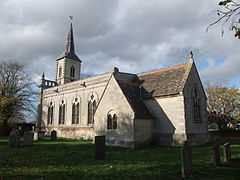 St Faith's Church, Wilsthorpe |
|
 Wilsthorpe |
|
| OS grid reference | TF091138 |
|---|---|
| – London | 90 mi (140 km) SSE |
| Civil parish | Braceborough and Wilsthorpe |
| District | South Kesteven |
| Shire county | Lincolnshire |
| Region | East Midlands |
| Country | England |
| Sovereign state | United Kingdom |
| Post town | Stamford |
| Postcode district | PE9 |
| Police | Lincolnshire |
| Fire | Lincolnshire |
| Ambulance | East Midlands |
| EU Parliament | East Midlands |
| UK Parliament | Gainsborough |
|
|
Coordinates: 52°42′41″N 0°23′11″W / 52.711325°N 0.386268°W
Wilsthorpe is a village in the district of South Kesteven in the county of Lincolnshire, England. It is situated approximately 6 miles (10 km) north-east from Stamford and approximately 4 miles (6 km) south from Bourne.
Originally a Chapelry in Greatford parish,[1] Wilsthorpe was created a civil parish in 1866 and lasted until 1931 when it was abolished to create the civil parish of Braceborough and Wilsthorpe.[2]
Wilsthorpe is mentioned in Domesday Book of 1086 when it was listed as having 20 households, 40 acres (0.2 km2) of meadow, 12 acres (0.05 km2) of woodland, and two mills.[3]
A possible Roman villa has been located as cropmarks to the south-east of the village,[4] and King Street is a Roman road.[5]
The church is a Grade II* listed building dedicated to Saint Faith. Built in 1715, it was restored and altered by James Fowler of Louth in 1869. In the sanctuary is a late-13th-century effigy of a knight in chain mail;[6] perhaps a Wake family member. Hereward the Wake was an Anglo-Saxon who led resistance to the Norman Conquest, and was born in or near Bourne.[7]
To the west of the village is the former railway station of Braceborough Spa Halt which was on the Essendine and Bourne Railway line. It opened in 1860 and closed in 1951. The old station house is now a private house.[8]
Nearby is the pumping station house from the old Peterborough Waterworks with its 52 feet (15.8 m) deep artesian well drilled during the late 19th century when it provided a million gallons of water each day to supply the cathedral city 14 miles (23 km) away.
References
- ↑ "Wilsthorpe". Vision of Britain. University of Portsmouth. Retrieved 12 August 2011.
- ↑ "Wilsthorpe civil parish". Vision of Britain. University of Portsmouth. Retrieved 12 August 2011.
- ↑ "Wilsthorpe". Domesday Map. Anna Powell-Smith/University of Hull. Retrieved 12 August 2011.
- ↑ "Wilsthorpe Roman Villa". Pastscape. English Heritage. Retrieved 12 August 2011.
- ↑ "King Street Roman Road, Wilsthorpe". Lincs to the Past. Lincolnshire Archives. Retrieved 12 August 2011.
- ↑ "St Faiths, Wilsthorpe". National Heritage List for England. English Heritage. Retrieved 12 August 2011.
- ↑ "Braceborough and Wilsthorpe". Lincolnshire Parishes. Lincolnshire County Council. Retrieved 12 August 2011.
- ↑ "Braceborough Spa Halt". Pastscape. English Heritage. Retrieved 12 August 2011.
External links
 Media related to Wilsthorpe, Lincolnshire at Wikimedia Commons
| ||||||||||||||||||||||