Wilsons Promontory National Park
| Wilsons Promontory National Park Victoria | |
|---|---|
|
IUCN category II (national park) | |
|
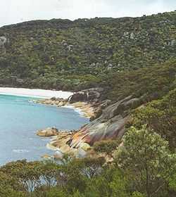
Colourful rocks within the national park | |
|
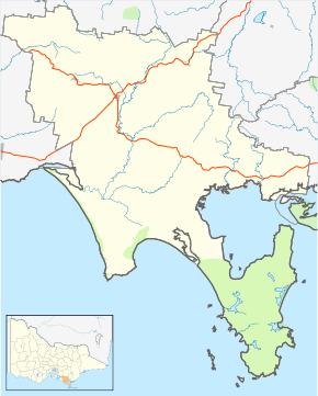
Map of South Gippsland with the national park shown in green on lower right | |
 Wilsons Promontory National Park | |
| Nearest town or city | Yanakie |
| Coordinates | 39°00′48″S 146°23′37″E / 39.01333°S 146.39361°ECoordinates: 39°00′48″S 146°23′37″E / 39.01333°S 146.39361°E |
| Established | July 1898 |
| Area | 505 km2 (195.0 sq mi)[1] |
| Managing authorities | Parks Victoria |
| Website | Wilsons Promontory National Park |
| See also | Protected areas of Victoria |
The Wilsons Promontory National Park,[2] commonly known as Wilsons Prom or The Prom, is a national park in the Gippsland region of Victoria, Australia, located approximately 157 kilometres (98 mi) southeast of Melbourne.
The 50,500-hectare (125,000-acre) national park is the southernmost national park on mainland Australia, known for its beautiful rainforests, unspoiled beaches, and abundant wildlife. The national park covers the southern portion of Wilsons Promontory, a peninsula containing South Point, the southernmost point on the Australian mainland. A lighthouse on the south-east corner of the peninsula is the southern-most lighthouse on mainland Australia and has operated continuously since 1859.
A large section of the park was burnt out in April 2005 by a bushfire caused by a controlled burn that breached containment lines because of warmer and windier conditions than were forecast for that day, causing the evacuation of six-hundred people.[3]
The park is highly popular with bushwalkers and campers, and has a number of lodges and serviced camping areas at a camping area near the mouth of Tidal River.
History
Indigenous Australians occupied the area at least 6,500 years ago based on archaeological records.
The first Europeans to sight Wilsons Promontory are believed to be George Bass and Matthew Flinders in 1798.
Extensive sealing took place at Sealer's Cove during the 19th Century, such that seals are no longer found there.
Lobbying by the Field Naturalists Club of Victoria and the Royal Society of Victoria (including Arthur Henry Shakespeare Lucas) led to the Government of Victoria temporarily reserve the area as National Park in 1898, made permanent in 1908. The original settlement in the Park was on the Darby River site, where a chalet existed.[4]
The Wilsons Promontory was used as commando training area during World War II. A memorial to commandos who lost their lives in World War II is located at Tidal River.
During the Black Saturday Fires of February 2009 throughout Victoria, trees in the Wilsons Promontory were struck by lightning, which then led to the loss of up to 50% of the national park through extensive fire damage.
Camping

The main campsite is at Tidal River, and consists primarily of unpowered sites for tents or caravans. Some cabins, huts and limited higher end options are also available. Booking is essential during the summer and other holiday periods throughout the year, as it is a popular holiday location.
The campsite is very close to the river and to an excellent ocean beach. Facilities include toilet and shower blocks, water near each site, a general store, an outdoor cinema (summer months only) and a visitor centre. Park rangers patrol the prom, interpretive activities are provided over the summer holiday period and at certain times medical staff are available.
Camping is not permitted outside designated camping areas, and the campsites at Sealer's Cove and other locations require a permit. Numerous other regulations apply.
Wildlife

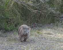
The Wilsons Promontory National Park is home to a wide range of wildlife species, including kangaroos, wombats, echidnas, emus, a wide range of small marsupials, and numerous species of birds, most prominent among which are the rosellas. Generally, the wildlife around Tidal River is accustomed to human presence, and many of the animals and birds near the campsites will approach humans, accept food from them, or even enter their tents uninvited. It is however illegal to feed wildlife and if you are found to be feeding them you will be issued with a fine by Parks Victoria Staff.
Outside the camping area, the wildlife is less accustomed to humans, and may be more difficult to spot. Possums can be quite easily found with a torch at night, and kangaroos and emus are often to seen in large numbers on either side of the road on the way in to the National Park. Swamp wallabies are frequently spotted on many of the walks, as are a variety of bird species. The northern section of the park is also home to an abundance of snakes.
Southern right whales nowadays show slow but steady recovery and started using the area as nursery like what was used to be along with Humpback whales that tend to pass through the area rather than long stay. Killer whales, dolphins, seals, sea lions, and penguins can be seen more regularly.
Hiking
The Prom has many different areas in which one can hike. There are trails of differing levels of difficulty, predominantly day hikes ranging from short strolls using beach access ramps up to longer 2 or 3 hour walks. Staff in the visitors centre can give helpful information and advice on walks to suit your skill level and timeframe. There are also several overnight hiking options which can be combined into larger circuit hikes from 2 days upwards. There are also multi-day hikes in the northern section of the park which require walkers to have excellent navigational skills. A permit is required for all overnight hiking.
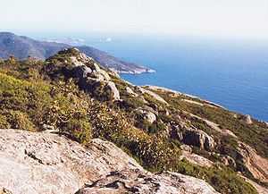
A portion of the peninsula is warm temperate rainforest. These areas are generally traversed on boardwalks and bridges and are full of wildlife, particularly bird species and swamp wallabies. There is also some mountainous terrain. Mount Oberon affords beautiful views that are only mildly marred by a radio aerial close by. An alternative walk up Mount Bishop also provides panoramic and spectacular views of the Prom. The coastline is ruggedly beautiful with indented coves and beaches interspersed amongst granite headlands, tors and cliffs. Beaches vary from broad sandy littoral plains to steep coves and rock pools. The northern part of the park comprises a great deal of the Yanakie isthmus with sandy healthlands.
Mount Oberon
Mount Oberon is also located in Wilsons Promontory National Park. Hikers usually take a vehicle halfway up the mountain to Telegraph Saddle car park and then continue on foot. Walkers follow the gently uphill management vehicle track to Mount Oberon’s summit. A short series of steps below the summit’s rocky outcrops, leads to views over Tidal River, the coast and islands offshore. Note that it can be windy, cool and clouded over at the summit, even during the summer months.
Civilisation
Wilsons Promontory is rather isolated, and the closest town is Yanakie located 36 kilometres (22 mi) north of Tidal River. Yanakie is very small, and is primarily consists of a general store and the Promhill Cabins. The settlement at Tidal River, however, does have a general store, café, fish and chip shop, open-air cinema (summer months only), post boxes and public telephones.
See also
- Protected areas of Victoria (Australia)
References
- ↑ "Wilsons Promontory National Park: Visitor Guide" (PDF). Parks Victoria (PDF). Retrieved 14 March 2010.
- ↑ "Wilsons Promontory National Park". Gazetteer of Australia. Geoscience Australia. Retrieved 14 June 2009.
- ↑ "Wilsons Promontory blaze inquiry continues". ABC News (Australia). 22 June 2005.
- ↑ "Wilsons Promontory National Park". Parks Victoria.
External links
| Wikimedia Commons has media related to Wilsons Promontory National Park. |
- "Wilsons Promontory National Park". Parks Victoria.
- "Home page". Friends of the Prom (FOTP).
- "Wilsons Promontory National Park". Explore Australia.
- Raymond, Robert (1985). Discover Australia's National Parks. Sydney: Macmillan.
- "Wilsons Promontory National Park - The Science of Managing the Terrestrial Environment". University of Melbourne.
- "Wilsons Promontory Lighthouse". Climate statistics for Australian locations. Bureau of Meteorology.