Wilshire Center, Los Angeles
Wilshire Center is a district that is part of the larger Mid-Wilshire district in the city of Los Angeles, California. It was founded in 1895 by Gaylord Wilshire and is one of the oldest communities in Los Angeles. It is 3–4 miles west of downtown Los Angeles.
Geography
Wilshire Center is bounded by Melrose Hill on the north, Westlake on the east, Koreatown on the south, and Hancock Park on the west.
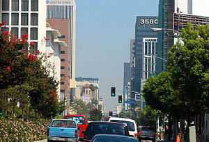
The Wilshire Center is a 'Regional Commercial Center' of approximately 100 acres (0.40 km2) in size and consisting of about 37,000,000 square feet (3,400,000 m2) of building area. It includes a dense collection of high-rise office buildings, large hotels, mini-malls, malls, churches, night clubs, and both high-rise and low-rise apartment and condominium buildings, as well as private houses. Wilshire Center includes three Metro subway stations along Wilshire Boulevard.
Names
Wilshire Center is sometimes referred to as Koreatown, K-Town, Mid-Wilshire and the Wilshire District. However, historically and officially, Wilshire Center is distinct. City signs designate the area as Wilshire Center. As defined by the Los Angeles Department of City Planning, Wilshire Community Plan, adopted September 19, 2001, Wilshire Center “is generally bounded by 3rd Street on the north, 8th Street on the south, Hoover Street on the east, and Wilton Place on the west”, and Koreatown “is generally bounded by Eighth Street on the north, Twelfth Street on the south, Western Avenue on the west, and continues east towards Vermont Avenue.”
Wilshire Center has a large concentration of Korean-owned businesses and an ethnically and economically diverse residential population. Within a one-mile (1.6 km) radius of Wilshire and Normandie (the approximate geographic center), there is a residential population of about 130,000 and a workforce of about 50,000.
The Wilshire Center Business Improvement District - WCBID was formed in 1995 as one of the first business improvement districts in Los Angeles.[1] The Wilshire Center Business Improvement District (WCBID) offers materials on the rich Wilshire Center history. The WCBID has been providing community services for the Wilshire Center since 1995.[2]
Transportation
Wilshire Center is served by city buses, including several Rapid lines, and three subway stations along Wilshire Boulevard. The Metro Purple Line, which begins at Union Station in Downtown Los Angeles, has stations at Vermont, Normandie and Western Avenues, where it terminates (an extension of the Purple Line subway along Wilshire blvd to Westwood/UCLA has been approved and is scheduled to be completed in stages thru 2020)[3] The Vermont station is also a stop on the Metro Red Line, which continues north through Hollywood to North Hollywood.[4][5]
The main east-west thoroughfare of Mid-Wilshire is Wilshire Boulevard which is served by numerous Metro Local, and Metro Rapid bus lines, as well as Foothill Transit Line 481. The main north-south thoroughfares are Western Avenue and Vermont Avenue (also heavily served by Metro Local/Metro Rapid service). Normandie, midway between them, is a secondary north-south thoroughfare with a Metro Local bus line. 3rd Street (Los Angeles) and 6th street are major east-west thoroughfares with Metro Local, Metro Local-Limited and Dash bus lines, and 8th Street & James M. Wood blvd (9th st.) are minor thoroughfares that function as alternatives to Wilshire Boulevard for local driving.
The Hollywood Freeway (U.S. Route 101) runs just to the north and east of Wilshire Center. Access to the Santa Monica Freeway (Interstate 10) is about three miles (5 km) to the south.
Wilshire Center has several bicycle lanes, including a 3.7-mile (6.0 km)-long designated bike route along residential 4th street between Hoover Street and Cochran Street (just west of La Brea Avenue) in the Hancock Park neighborhood, another 4.2 mile long route on 7th street from Spring street downtown to Catalina street, and a new route along New Hampshire street from the 101 freeway to 7th street.[6] Another bicycle route is currently proposed for Oxford Avenue (just east of Western Avenue) between Melrose Avenue and Pico Boulevard.
Parking within the Mid-Wilshire neighborhood is often difficult. The area is the densest neighborhood in Los Angeles, and many older multi-unit buildings lack off-street parking. Side streets have weekly street sweeping schedules on alternate sides. Several side-streets also have preferential parking restrictions for those with permits only, while others have two-hour daytime parking limits. Main thoroughfares often have metered street parking. In addition, most main thoroughfares within Mid-Wilshire also have strict rush-hour parking restrictions in place in order to provide an additional lane of through traffic to help alleviate the severe traffic congestion common in this area during commuting hours. Weekday peak-hour (anti-gridlock zone) restrictions are strictly enforced with ticketing and towing by the Los Angeles Department of Transportation.
History
Wilshire Boulevard is named for Henry Gaylord Wilshire--a millionaire who in 1895 began developing a 35-acre (140,000 m2) parcel stretching westward from Westlake Park (MacArthur Park) for an elite residential subdivision. A socialist, Wilshire donated to the city a strip of land for a boulevard on the conditions that it would be named for him and ban public transit, railroad lines, and commercial or industrial trucking and freight trains.
In the early 1900s, steam-driven motorcars started sharing Wilshire Boulevard with horse-drawn carriages. At the turn of the century, Germain Pellissier raised sheep and barley between Normandie and Western Avenues. Reuben Schmidt purchased land east of Normandie for his dairy farm.
Information
- Tour of Wilshire Boulevard: Exploring Wilshire Boulevard's history and historical buildings.
- Wilshire Angels Walk LA: A walking tour of Wilshire Center's history and historical buildings by way of guidebook and map (download link).
- Wilshire Boulevard Milestones: The Wilshire Center's history, by Larchmont Chronicle publisher by Jane Gilman.
Apartment buildings
Distinguished high-rise apartment buildings and hotels were erected along Wilshire Boulevard. The lavish Ambassador Hotel was built in 1921 on 23 acres (93,000 m2) of the former site of Reuben Schmidt's dairy farm. In approximately 1929, the Academy Awards ceremony was moved from the Hollywood Roosevelt Hotel to the Ambassador Hotel. It closed in 1989 and, despite efforts of historic preservationists, has been demolished. The site is owned by the Los Angeles Unified School District, which in 2010 opened the Robert F. Kennedy Community Schools and a small park on the site. It is the most expensive public school in the United States.
The area nearby became the site of elegant New York-style apartment buildings such as the Asbury, the Langham, the Fox Normandie, the Picadilly, the Talmadge (after Norma Talmadge), the Gaylord, and the Windsor. Many film stars lived in these buildings.
The Chapman Park Hotel on Wilshire Boulevard in Wilshire Center was where the female athletes were housed for the 1932 Los Angeles Summer Olympic Games. (The male athletes were housed at the very first Olympic Village built, up in the nearby Baldwin Hills range, in the Baldwin Hills district.[7])
A recent building boom has increased the supply of apartments and condominiums in the area, and older office buildings have been converted into apartments and condos. Large apartment buildings have been constructed at the Metro stops at Wilshire/Western and Wilshire/Vermont.
Commercial
Gloria Swanson's husband, Herbert Somborn, opened the Brown Derby Restaurant, a hat-shaped building at Wilshire and Alexandria, in 1926. The hat now sits on top of a restaurant in a mini-mall.
In 1929, the elegant Art-Deco Bullocks Wilshire was built at Wilshire and Westmoreland as the city's first branch department store in the suburbs. It closed in 1993 and now houses the library of Southwestern Law School.
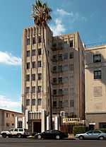
A section of Germain Pellessier's sheep farm became the site of the Pellessier Building and Wiltern Theatre, which began construction at the corner of Wilshire and Western in 1929. The theater, operated by Warner Brothers, opened in 1931.
In 1929, the Chapman Market drew motorcars to the world's first drive-through grocery store at Sixth St and Alexandria.
The San Francisco based I. Magnin opened a store in 1939 at Wilshire and New Hampshire.
Office buildings
In 1952, on the driving range on the south side of Wilshire between Mariposa and Normandie, the first three 12-story Tishman Plaza buildings were built in 1952 (they're now known as Central Plaza), designed by Claude Beelman.
Insurance companies began locating their West Coast headquarters in Wilshire Center because of tax incentives provided by the State. Some 22 high-rise office buildings were erected on Wilshire Boulevard from 1966 to 1976 to provide office space for such companies as Getty Oil Co., Ahmanson Financial Co., Beneficial Standard Life Insurance, Wausau, and Equitable Life Insurance. The Chapman Park Hotel, built in 1936, was torn down to make way for the 34-story Equitable Plaza office building erected in 1969. By 1970, firms such as CNA, Pacific Indemnity, and Pierce National Life were starting construction of their own high-rise buildings. Southwestern University School of Law moved from its downtown location of 50 years to a four-story campus just south of Wilshire Boulevard on Westmoreland in 1973.
In the 1970s and 1980s, commerce moved to the city's less congested Westside as well as the San Fernando Valley, and businesses and affluent residents eventually followed. I. Magnin closed, while Bullocks Wilshire held out until 1993. Rental rates in office buildings plummeted from an average of $1.65/sq ft to a dollar between 1991 and 1996; property values dropped from a high of $120/sq ft to $30 or $40 per foot in 1998.
Wilshire Center lost most of its remaining original glitter following the 1992 Los Angeles riots and the 1994 Northridge earthquake.
Subsequently, the Wilshire Center Streetscape Project used federal funds to rejuvenate Wilshire Boulevard. It was one of the most ambitious and significant urban rehabilitation projects found anywhere in America and in 1999 was awarded the Lady Bird Johnson Award from The National Arbor Day Foundation. New buildings include the Aroma Center on Wilshire, which is topped by a large digital billboard, and a modern retail building facing 6th Street on the former parking lot of the Equitable Building.
Billboard district
As of 2009, the city of Los Angeles is considering a sign ordinance that would increase the number of billboards and allow more digital billboards in Wilshire Center in the area that includes Wilshire Boulevard, with the following boundaries:
- East: Park View St
- West: Wilton Place
- North: W. 6th St
- South: W. 7th St
Religious buildings
Wilshire Christian Church was the first church on Wilshire Boulevard in 1911. The church property at Wilshire and Normandie was donated by the Chapman Brothers, owners of Chapman Market, whose historic building remains nearby on Sixth Street.
The area is rich in grand religious buildings, as well as many Korean Buddhist temples and smaller churches in the area as well.
- Korean Philadelphia Presbyterian Church, on New Hampshire Avenue, formerly the Sinai Congregation
- The Los Angeles Korean Methodist Church, at 4th and Normandie, formerly a Christian Science congregation
- Immanuel Presbyterian Church (Wilshire & Berendo)[8]
- First Congregational Church of Los Angeles (6th & Commonwealth)[9]
- St. James Episcopal Church (Wilshire & St Andrews)[10]
- First Baptist Church of Los Angeles (8th & Westmoreland)[11]
- St Basil's Catholic Church, a modern building, on Wilshire
- Founder's Church of Religious Science, on 6th Street
- Wilshire Boulevard Temple (Reform Jewish)
- The Islamic Center of Southern California, a modern building, on Vermont
Community organizations
- The Wilshire Center Business Improvement Corp.(WCBIC)
- CRA Wilshire Center/Koreatown Citizen Advisory Committee
- The Wilshire Center/Koreatown Neighborhood Council (WCKNC)]
Economy
The law firm Moxon & Kobrin has its headquarters in the Wilshire Center Building in Wilshire Center.[12][13][14]
The airline Aviacsa had an office in Wilshire Center.[15]
Education and services
Wilshire Center is zoned to the Los Angeles Unified School District. All areas are zoned to Los Angeles High School.
Schools include:
- Los Angeles Elementary School
- Wilton Place Elementary School
- Berendo Middle School
- Burroughs Middle School
Private schools include Wilshire Private School Wilshire Private School (a K-6 academy sponsored by the Korean Institute of Southern California) about 2 miles (3.2 km) west on the western border of Hancock Park.
The Pio Pico-Koreatown branch of the Los Angeles Public Library is located at 7th and Oxford Streets.
A new facility and parking structure of the YMCA of Metropolitan Los Angeles is under construction at Third and Oxford Streets (September 2013). The Anderson-Munger Family YMCA will open in 2014.
There are no city parks or community gardens in Wilshire Center, and only small parks in the surrounding communities. This is one of the most 'park-poor' areas of the city.
Gallery
-

Wilshire Christian Church
-
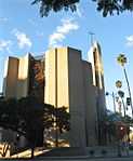
St. Basil Catholic Church
-
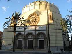
Wilshire Boulevard Temple
-
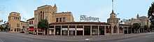
The historic Chapman Market today
-

First Baptist Church
See also
- Harold A. Henry, Los Angeles City Council president active in improving Wilshire Center
References
- “Wilshire Boulevard Milestones," by Jane Gilman, publisher of Larchmont Chronicle.
- The Curating the City Tour Book by the Los Angeles Conservancy
- “Streetscape: the Plan that Saved a Community” by David Wallace.
- Wilshire Center
- Tour of Wilshire Boulevard
Notes
- ↑ http://labidconsortium.org/
- ↑ http://www.wilshirecenter.com/
- ↑ http://www.metro.net/projects/westside/
- ↑ http://www.metro.net/around/maps/ . accessed 8/22/2010
- ↑ http://www.metro.net/around/ . accessed 8/22/2010
- ↑ Los Angeles Department of Transportation Bike Map
- ↑ 1932 Los Angeles Olympic Athlete's Village in the Baldwin Hills, Accessed November 12, 2007.
- ↑ http://www.immanuelpres.org/
- ↑ http://www.fccla.org/
- ↑ http://www.saintjamesla.org/
- ↑ http://www.fbcofla.org/
- ↑ "Office Space." Wilshire Center Business Improvement District. Retrieved on January 19, 2011. "3055 Wilshire Blvd. Wilshire Center Bldg."
- ↑ "Maps." Wilshire Center Business Improvement District. Retrieved on January 19, 2011. Boundaries shown are a line immediately south of West 8th Street, a line west of South Wilton Place, a line north of West Third Street, and a line east of South Hoover Street, so that buildings on both sides of the streets are in the district. The district boundaries have squared edges, including the buildings at the edges.
- ↑ "Case No. BS 116340 Case No. BS 116339." Superior Court of the State of California for the County of Los Angeles. Retrieved on January 19, 2011. "3055 Wilshire Blvd. Suite 900 Los Angeles, CA 90010"
- ↑ "DIRECTORIO." Aviacsa. Retrieved on January 23, 2011.
| |||||||||||||||||
| |||||||||||||||||
