Williams Cone
| Williams Cone | |
|---|---|
 | |
| Elevation | 2,080 m (6,820 ft) |
| Prominence | 90 m (300 ft) |
| Location | |
| Location | British Columbia, Canada |
| Coordinates | 57°46′48.0″N 130°35′56.4″W / 57.780000°N 130.599000°WCoordinates: 57°46′48.0″N 130°35′56.4″W / 57.780000°N 130.599000°W |
| Topo map | NTS 104G/15 |
| Geology | |
| Type | Cinder cone |
| Age of rock | Holocene |
| Volcanic arc/belt | Northern Cordilleran Volcanic Province |
| Last eruption | 1340 BP |
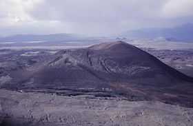
Williams Cone is a satellite cone of Mount Edziza, located 36 kilometers east of Telegraph Creek. It lies just off the northern edge of the Tencho Icefield and is one of the many postglacial cinder cones that lie on the Mount Edziza volcanic complex. Williams Cone last erupted about 1,350 years ago along with other nearby volcanoes, such as the well-preserved Eve Cone.[1]
See also
- List of volcanoes in Canada
- List of Northern Cordilleran volcanoes
- Volcanism of Canada
- Volcanism of Western Canada
References
- ↑ Catalogue of Canadian volcanoes: Williams Cone Retrieved on 2007-10-14
| ||||||||||||||||||