Willerby, East Riding of Yorkshire

Coordinates: 53°45′48″N 0°27′02″W / 53.76328°N 0.450430°W
Willerby is a village and civil parish located on the western outskirts of the city of Kingston upon Hull in the East Riding of Yorkshire, England.
Willerby was a minor settlement up to the 20th century, during which it became a suburb of Kingston upon Hull, and its urban development extended south-eastwards towards Hull. The village centre is located about 5 miles (8 km) west of Kingston upon Hull city centre and lies outside the city boundary.
History
Up to the 20th century Willerby was a small village.[2]
Enclosure of land around Willerby was enabled by acts of parliament in 1796 and 1824.[3] In 1844 the population of the 820 acres (3.3 km2) township of Willerby was 214 persons, in 45 houses.[4] By the 1850s Willerby had a primitive methodist chapel (built 1850),[5] a Hall, Oak Hill House,[6] dating from the late 17th or early 18th century, now known as Willerby Hall,[2][7] and another large dwelling, the Summer House,[6] later known as The Beeches dating to the 18th century, and extended in the 1820s and 1850s.[8] as well as smaller dwellings along Main Street, the village's original main road.[6]
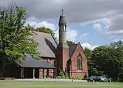
A mental asylum, Hull Borough Lunatic Asylum, later known as De La Pole hospital, and an associated chapel, was constructed beyond the village to the north in the 1880s.[2][note 1] Willerby and Kirk Ella railway station opened in 1885 as part of the Hull and Barnsley Railway which passed the main village close by on the southern edge.[11][12]
By 1890 two further substantial houses had been built; Manor House (later Willerby Manor),[12][note 2] and The Grange, north of the village.[note 3][12] A new Methodist chapel and schoolroom were constructed in 1897/1900.[2]
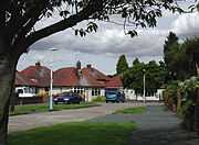
Small scale growth of housing started in the 20th century, with suburban developments eastward towards Hull along Kingston Road and Carr Lane well developed by the mid 20th century.[17]
The beehive manufacturing company Yorkshire Apiary Company based in Willerby was commissioned to produce temporary buildings in the aftermath of the Second World War;[18] the company, Willerby Caravan Company Ltd., (founded 1944, since 1996 Willerby Holiday Homes) was located on Main Street, the company later relocated to Hedon Road, Kingston upon Hull.[19][note 4]
In 1959 Willerby and Kirkella station closed,[11] the line closed completely in 1964, and the station was demolished in 1968, and the site used for a housing development.[20] Part of the route of the line was used (1970) to construct the B1232 forming a bypass for the A164 (Beverley) road, bypassing Willerby village.[21][22]
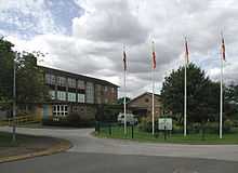
Willerby Carr Lane County Primary School was established in the 1930s.[23] In 1960 Willerby County Secondary School (now the lower school of Wolfreton School) was officially opened, though construction and extension continued through the 1960s and early 1970s.[24] A third Methodist chapel, and the Anglican church of St. Luke, were also constructed in the late 1960s.[2]
By the late 1960s urban development west of the traditional village centre, in the land between Carr Lane and the Hull and Barnsley railway line had reached modern (2012) levels, with the village now an effective suburb of Hull, separated by the green space of Springhead Golf Course. Further development of housing estates took place in the latter part of the 20th century, north of Carr Lane.[25]
|

Government
Willerby is situated within the safe Conservative Parliamentary Constituency of Haltemprice and Howden;[26] the Haltemprice and Howden Conservative party branch is based in Willerby, on Main Street.[27] The village lies within the East Riding of Yorkshire Council electoral ward of 'Willerby and Kirk Ella'.[28]
Geography
As of 2012 the village of Willerby forms an outermost western suburb of Hull, separated by non-agricultural green space including allotments, playing fields, and Springhead Park Golf Club.[29] In the second half of the 20th century urban development became contiguous between the villages of Willerby, Kirk Ella to the south and Anlaby to the south-east.[30] The northern half of the parish remains in agricultural use, and includes Haltemprice Priory farm, which contains archaeological remnants of the Augustinian Haltemprice Priory.[29]
The boundaries of the modern civil parish of Willerby are formed by the route of the former Hull and Barnsley Railway (including the B1232 road) to the south, the A164 Beverley to Humber Bridge road to the west, and Sand Sike drainage channel in Springhead Park to the west. The northern boundary is with the civil parish of Cottingham.[29][31] The parish rises from less than 33 feet above sea level in the east to approximately 130 feet at the western boundary, beyond which are the foothills of the Yorkshire Wolds in the parish of Skidby.[29]
To the west of the village is Willerby Retail Park,[32] which houses a Waitrose supermarket, (formerly Safeway, 2004.[33]). Willerby has two hotels, converted from late 19th century houses, "The Grange", as of 2012, the Mecure Hull West Hotel,[note 3] and Willerby Manor.[note 2] The 1960 buildings of the lower school of Wolfreton School are within the civil parish of Willerby.[24]
According to the 2011 UK census, Willerby parish had a population of 7,940,[1] a reduction on the 2001 UK census figure of 8,056.[31]
|


See also
- Fairview Studios, a recording studio situated in the village.
- Haltemprice Priory, former monastery and farm to the north-east of Willerby
Notes
- ↑ TA024317, De La Pole hospital, formerly Hull Borough Lunatic Asylum, closed 1997, demolished and redeveloped. Chapel and other associated buildings survive.[9] now within the civil parish of Cottingham, East Riding of Yorkshire. The chapel gained listed building status in 1997,[10] as of 2012 forms part of Haltemprice Crematorium.
- ↑ 2.0 2.1 TA025304, Willerby Manor, built mid 19th century,[2] later used as a hotel. As of 2012, "Best Western Willerby Manor Hotel".[13]
- ↑ 3.0 3.1 TA021311, The Grange. Site later used as a hotel "Grange Park" with substantial extension (1990),[14] Operated as part of Ramada Jarvis chain (2000s),[15] as of 2012 part of Mercure Hotels hotel chain.[16]
- ↑ 53°45′29″N 0°26′57″W / 53.75813°N 0.449165°W, Willerby Caravan Company, former site
References
- ↑ 1.0 1.1 "Key Figures for 2011 Census: Key Statistics: Area: Willerby CP (Parish)". Neighbourhood Statistics. Office for National Statistics. Retrieved 7 February 2013.
- ↑ 2.0 2.1 2.2 2.3 2.4 2.5 Pevsner, Nikolaus; Neave, David (1995). "Willerby". Yorkshire: York And the East Riding, Second Edition. Yale University Press. pp. 755–6. ISBN 0 300 09593 7.
- ↑ Woolley, William, ed. (1830). "Chronological Table". A collection of statutes relating to the town of Kingston-upon-Hull, the county of the same town and the parish of Sculcoates. Simpkin and Marshall. pp. xi–xxviii.
- ↑ Clarke, Benjamin (1852). "Willerby, East Riding, York". The British Gazetteer, Political, Commercial, Ecclesiastical, and Historical. 3 (L-Z). H.G. Collins.
- ↑ Wolfe, John, ed. (2000). "Sculcoates District : Willerby". Yorkshire Returns of the 1851 Census of Religious Worship. Volume 1: Introduction, City of York and East Riding. Borthwick Publications, Borthwick Institute of Historical Research, University of York. p. 58. ISBN 0-903857-95-2.
- ↑ 6.0 6.1 6.2 Ordnance Survey, Sheet 225, 6" to 1 mile (1:10560), 1855
- ↑ Historic England. "Willerby Hall (1103366)". National Heritage List for England. Retrieved 6 December 2012.
- ↑ Historic England. "The Beeches (1103365)". National Heritage List for England. Retrieved 6 December 2012.
- ↑ Sources:
- Bickford, J.A.R.; Bickford, M.E. (1976). "The Private Lunatic Asylums of the East Riding" (PDF). East Yorkshire Local History Society. pp. 10, 14. Retrieved 7 February 2013.
- Roberts, Andrew (ed.). "Index of English and Welsh Lunatic Asylums and Mental Hospitals". Middlesex University. Yorkshire: Hull area. Retrieved 7 February 2013.
- Taylor, Jeremy; Cornwell, Simon; Cracknell, Peter. "Alphabetical Asylum List". www.thetimechamber.co.uk. De La Pole,Willerby, Hull, Humberside. Retrieved 7 February 2013.
- ↑ Historic England. "Church At De La Pole Hospital (Block 49) (1376808)". National Heritage List for England. Retrieved 3 December 2012.
- ↑ 11.0 11.1 Butt, R. V. J. (1995). The Directory of Railway Stations: details every public and private passenger station, halt, platform and stopping place, past and present (1st ed.). Sparkford: Patrick Stephens Ltd. ISBN 1-8526-0508-1. OCLC 60251199.
- ↑ 12.0 12.1 12.2 Ordnance survey, Sheet 225SE, 6" to 1 mile, 1891
- ↑ "Willerby Manor Hotel". Best Western. Retrieved 15 May 2012.
- ↑ Caterer & hotelkeeper 183. IPC Consumer Industries Press. 1990. p. 383.
Following completion of a £2 million bedroom/conference wing making the Grange Park the largest on Humberside
- ↑ Godfrey-Faussett, Charles (2004). Footprint England. Footprint Travel Guides. "Hull", p.718.
- ↑ "Mercure Hull West Hotel". Mecure Hotels. Retrieved 15 May 2012.
- ↑ Ordnance survey. Sheet 225SE. 1910, 1929, 1938, 1956
- ↑ Graham, James (28 August 2001). "Caravans – the bee’s knees as far as Hull is concerned". Yorkshire Evening Post. Retrieved 7 February 2013.
- ↑ Sources:
- Jenkinson, Andrew (2003). Caravans: The Illustrated History 1919–1959. Veloce Publishing. p. 65.
- Kelly's manufacturers and merchants directory, including industrial services, Volume 1 82. Kelly's Directories Ltd. 1968. "Willerby Caravan Co. Ltd.", p.2330.
- "Company History". Willerby Holiday Homes. Retrieved 12 May 2012.
- "Willerby Holiday Homes Ltd. Company No. 00387583". Companies House. Retrieved 7 February 2013.
- ↑ Dyson, Mark (14 July 2012). "Station Name: Willerby & Kirk Ella". Disused Stations. Subterranea Britannica. Retrieved 7 February 2013.
- ↑ Ordnance survey. 1:2500, 1964–71; 1:10560, 1968; 1:10560, 1977–80 maps
- ↑ Road and Rail Facilities (Investment). Parliamentary debates (Hansard): House of Commons official report (H.M.S.O.). 1970. p. cxlv.
A diversion of the A164 to bypass Willerby is under construction
- ↑ Ordnance survey. 1:10560. 1929, 1938. TA033304
- ↑ 24.0 24.1 Sources:
- "Wolfreton School Building Works Timeline". Wolfreton School and Sixth Form College. Retrieved 15 May 2012.
- Ordnance survey. 1:10560. 1968. TA028303
- ↑ Ordnance survey, 1:10560; 1956, 1968. 1:10000; 1977–80, 1989, 1994–5
- ↑ "Haltemprice and Howden". The Guardian. Retrieved 12 May 2012.
- ↑ "Political Organisations And Representatives in Willerby". Yellow Pages. Retrieved 12 May 2012.
- ↑ "Ward Profile Selection: Willerby and Kirk Ella Geography: Ward". East Riding of Yorkshire Council. Retrieved 12 May 2012.
- ↑ 29.0 29.1 29.2 29.3 Ordnance survey, 1:2500, 2012
- ↑ Ordnance survey. 1:10560: 1938; 1956; 1968, 1:10000: 1977–80; 1989; 1994–5
- ↑ 31.0 31.1 "2001 Census: Key Statistics: Parish Headcounts: Area: Willerby CP (Parish)". Neighbourhood Statistics. Office for National Statistics. Retrieved 20 May 2008.
- ↑ "Willerby Retail Park". www.wykeland.co.uk. Archived from the original on 24 June 2008. Retrieved 2 December 2012.
- ↑ Finch, Julia (26 March 2004). "Waitrose buys former Safeway stores". The Guardian. Retrieved 15 May 2012.
External links
| Wikimedia Commons has media related to Willerby. |
| ||||||||||||||||||||||||||