Wilczek Land
| Native name: <span class="nickname" ">Земля Вильчека | |
|---|---|
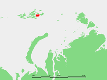 Location of Wilczek Land in the Franz Josef Archipelago | |
 Wilczek Land (Russia) | |
| Geography | |
| Location | Arctic Ocean |
| Coordinates | 80°35′00″N 60°30′00″E / 80.583333°N 60.5°E |
| Archipelago | Franz Josef Land |
| Area | 2,203 km2 (851 sq mi) |
| Highest elevation | 606 m (1,988 ft) |
| Highest point | unnamed |
| Country | |
| Oblast | Arkhangelsk Oblast |
Wilczek Land (Russian: Земля Вильчека; Zemlya Vil'cheka, German: Wilczek-Land), is a large-sized island located at 80°35′00″N 60°30′00″E / 80.5833333°N 60.5°E. It is a part of Franz Josef Land, Russia.
Wilczek Land is the second largest island of the Franz Josef Archipelago. It is almost completely glaciarized except for two narrow areas along its western shores. The highest point on the island is 606 m.
This large island is named after Austro-Hungarian Count Johann Nepomuk Wilczek.[1] Count Hans Wilczek was the most important sponsor of the Austro-Hungarian North Pole Expedition to Franz Josef Land.
Mys Ganza is Wilczek Land's westernmost cape. The channel to the west, between Wilczek Land and Gallya is known as Avstriyskyy Proliv (Австрийский пролив).
This island should not be confused with small Wilczek Island, "Остров Вильчека", located Southwest of Salm Island, in the Franz Josef group itself and which was also named after the same person.
History
Cape Geller (80°46′N 59°36′E / 80.767°N 59.600°E) was the wintering site for two members of the 1899 Welle Expedition waiting for their team's return from the pole.
Adjacent small islands
- Off Wilczek Land's southern bay, lies a small island called Klagenfurt Island (Остров Клагенфурт) about 9 km away from the shore. This island is named after Klagenfurt (Slovene: Celovec), the capital of Carinthia.
- Right off Wilczek Land's eastern coast lie two small islets called Ostrova Gorbunova (Острова Горбунова) their location is (80°34′N 62°01′E / 80.567°N 62.017°E). These islets were named after Russian naturalist Gregory Petrovich Gorbunov.
- 1.5 km off Wilczek land's southeastern cape lie four islets in a row called (from NE to SW):
- Ostrov Derevyannyy (Остров Деревянный).
- Ostrov Daues (Остров Дауэс) or Davis Island, was named after Antarctic navigator John King Davis.
- Ostrov Mak-Nulta (Остров Мак-Нульта).
- Ostrov Tillo (Остров Тилло), named after Ukrainian cartographer Oleksiy Tillo. This island should not be confused with Tillo Island in the Kara Sea.