Wila Sirka
For the mountain in Peru, see Wila Sirka (Peru).
| Wila Sirka | |
|---|---|
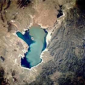 Poopó Lake from above. Wila Sirka lies in the roundish mountainous complex at its south-eastern end. | |
| Elevation | 4,906 m (16,096 ft)[1] |
| Location | |
 Wila Sirka Location in Bolivia | |
| Location | Bolivia, Oruro Department, Sebastián Pagador Province |
| Range | Andes |
| Coordinates | 18°57′53″S 66°40′57″W / 18.96472°S 66.68250°WCoordinates: 18°57′53″S 66°40′57″W / 18.96472°S 66.68250°W |
Wila Sirka (Aymara wila blood, red, sirka vein,[2][3] "red vein", also spelled Wila Sirca) is a 4,906-metre (16,096 ft) high mountain in the Andes of Bolivia. It is located in the Oruro Department, Sebastián Pagador Province, which is identical to the Santiago de Huari Municipality. Wila Sirka lies between the mountains Azanaques in the west and Sirk'i in the east.
The river Jach'a Qala ("big stone", hispanicized spelling Jachcha Khala) originates north of the mountain. It flows to the south.[1][4]
See also
References
- ↑ 1.0 1.1 BIGM map 1:50,000 6237-II Cerro Azanaques
- ↑ Radio San Gabriel, "Instituto Radiofonico de Promoción Aymara" (IRPA) 1993, Republicado por Instituto de las Lenguas y Literaturas Andinas-Amazónicas (ILLLA-A) 2011, Transcripción del Vocabulario de la Lengua Aymara, P. Ludovico Bertonio 1612 (Spanish-Aymara-Aymara-Spanish dictionary)
- ↑ "Diccionario Quechua - Aymara al español". katari.org. Retrieved September 5, 2014.
- ↑ "Santiago de Huari". ine.gob.bo. Retrieved September 5, 2014.
| |||||||||||||||||
